

<< Our Photo Pages >> Dolmen de La Croix Blanche (Eure) - Burial Chamber or Dolmen in France in Normandie:Eure (27)
Submitted by holger_rix on Monday, 25 January 2016 Page Views: 1538
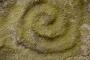
Neolithic and Bronze AgeSite Name: Dolmen de La Croix Blanche (Eure)Country: France Département: Normandie:Eure (27) Type: Burial Chamber or Dolmen
Nearest Town: Les Andelys Nearest Village: Surville
Latitude: 49.189833N Longitude: 1.098222E
Condition:
| 5 | Perfect |
| 4 | Almost Perfect |
| 3 | Reasonable but with some damage |
| 2 | Ruined but still recognisable as an ancient site |
| 1 | Pretty much destroyed, possibly visible as crop marks |
| 0 | No data. |
| -1 | Completely destroyed |
| 5 | Superb |
| 4 | Good |
| 3 | Ordinary |
| 2 | Not Good |
| 1 | Awful |
| 0 | No data. |
| 5 | Can be driven to, probably with disabled access |
| 4 | Short walk on a footpath |
| 3 | Requiring a bit more of a walk |
| 2 | A long walk |
| 1 | In the middle of nowhere, a nightmare to find |
| 0 | No data. |
| 5 | co-ordinates taken by GPS or official recorded co-ordinates |
| 4 | co-ordinates scaled from a detailed map |
| 3 | co-ordinates scaled from a bad map |
| 2 | co-ordinates of the nearest village |
| 1 | co-ordinates of the nearest town |
| 0 | no data |
Be the first person to rate this site - see the 'Contribute!' box in the right hand menu.
Internal Links:
External Links:
")
Surville, Les Andelys, Eure, Normandie
Source: T4T35.fr
You may be viewing yesterday's version of this page. To see the most up to date information please register for a free account.
 (PID:147696)")
Do not use the above information on other web sites or publications without permission of the contributor.
Nearby Images from Flickr


The above images may not be of the site on this page, but were taken nearby. They are loaded from Flickr so please click on them for image credits.
Click here to see more info for this site
Nearby sites
Click here to view sites on an interactive map of the areaKey: Red: member's photo, Blue: 3rd party photo, Yellow: other image, Green: no photo - please go there and take one, Grey: site destroyed
Download sites to:
KML (Google Earth)
GPX (GPS waypoints)
CSV (Garmin/Navman)
CSV (Excel)
To unlock full downloads you need to sign up as a Contributory Member. Otherwise downloads are limited to 50 sites.
Turn off the page maps and other distractions
Nearby sites listing. In the following links * = Image available
6.8km E 97° Allée Couverte de Pinterville Passage Grave
7.9km ESE 120° Dolmen de la Croix (Acquigny) Burial Chamber or Dolmen
8.6km NE 51° Saint-Etienne-du-Vauvray Menhir* Standing Stone (Menhir)
9.7km NE 51° St-Etienne-du-Vouvray burial chamber* Burial Chamber or Dolmen
10.0km E 84° Monolithe de la Croix Roger Ancient Cross
10.4km NE 47° Val de Reuil et Portejoie burial chamber Burial Chamber or Dolmen
12.5km NE 36° Léry Dolmen Burial Chamber or Dolmen
16.1km NE 40° Poses burial chamber Burial Chamber or Dolmen
16.9km E 98° Aubevoye Dolmen Burial Chamber or Dolmen
17.9km NNE 19° Boos Dolmen* Burial Chamber or Dolmen
18.9km SSE 168° Musée de l'Ancien-Evêché* Museum
19.0km N 7° Grotte préhistorique de Gouy* Cave or Rock Shelter
21.3km E 95° Tombeau de Saint-Ethbin* Burial Chamber or Dolmen
21.8km E 95° Menhir dit Gravier de Gargantua (Chateau-Neuf)* Standing Stone (Menhir)
22.1km N 349° Menhir dit la Pierre d'Etat* Standing Stone (Menhir)
22.3km N 6° Pierre druidique de Belbeuf Standing Stone (Menhir)
22.9km S 169° Tumulus d'Angerville Round Barrow(s)
24.0km NW 312° Pierre Tournante (Bosgouet)* Burial Chamber or Dolmen
24.1km SE 127° Houlbec-Cocherel burial chamber Burial Chamber or Dolmen
24.2km ENE 75° monument druidique Burial Chamber or Dolmen
25.4km S 185° Dolmen de l'Hôtel-Dieu* Burial Chamber or Dolmen
25.8km ESE 109° St-Pierre-d'Autils grotte sepulchral Cave or Rock Shelter
25.8km NNW 329° Allée Couverte de Mauny* Passage Grave
25.9km ESE 108° Trou aux Anglais (St-Pierre-d'Autils) Ancient Village or Settlement
26.3km NE 43° Pierre Saint-Martin (Fleury-sur-Andelle) Standing Stone (Menhir)
View more nearby sites and additional images


 We would like to know more about this location. Please feel free to add a brief description and any relevant information in your own language.
 Wir möchten mehr über diese Stätte erfahren. Bitte zögern Sie nicht, eine kurze Beschreibung und relevante Informationen in Deutsch hinzuzufügen.
 Nous aimerions en savoir encore un peu sur les lieux. S'il vous plaît n'hesitez pas à ajouter une courte description et tous les renseignements pertinents dans votre propre langue.
 Quisieramos informarnos un poco más de las lugares. No dude en añadir una breve descripción y otros datos relevantes en su propio idioma.