<< Our Photo Pages >> Cacaxtla - Ancient Village or Settlement in Mexico in Tlaxcala
Submitted by SolarMegalith on Sunday, 10 April 2011 Page Views: 6059
Multi-periodSite Name: CacaxtlaCountry: Mexico
NOTE: This site is 20.871 km away from the location you searched for.
Region: Tlaxcala Type: Ancient Village or Settlement
Nearest Town: Puebla
Latitude: 19.244167N Longitude: 98.344444W
Condition:
| 5 | Perfect |
| 4 | Almost Perfect |
| 3 | Reasonable but with some damage |
| 2 | Ruined but still recognisable as an ancient site |
| 1 | Pretty much destroyed, possibly visible as crop marks |
| 0 | No data. |
| -1 | Completely destroyed |
| 5 | Superb |
| 4 | Good |
| 3 | Ordinary |
| 2 | Not Good |
| 1 | Awful |
| 0 | No data. |
| 5 | Can be driven to, probably with disabled access |
| 4 | Short walk on a footpath |
| 3 | Requiring a bit more of a walk |
| 2 | A long walk |
| 1 | In the middle of nowhere, a nightmare to find |
| 0 | No data. |
| 5 | co-ordinates taken by GPS or official recorded co-ordinates |
| 4 | co-ordinates scaled from a detailed map |
| 3 | co-ordinates scaled from a bad map |
| 2 | co-ordinates of the nearest village |
| 1 | co-ordinates of the nearest town |
| 0 | no data |
Internal Links:
External Links:
I have visited· I would like to visit
SolarMegalith visited on 1st Apr 2004 - their rating: Cond: 3 Amb: 3 Access: 4
")
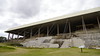
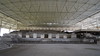
Cacaxtla was one of the main cities of Olmeca-Xicalanca culture, origins of which are connected with areas of current Veracruz. The most important preserved structure is Gran Basamento, in which famous paintings are preserved. The best preserved among them is Mural de la batalla, dated for 8th century AC.
Currently the excavations are protected with a roof, there is also a small museum next to the site. The footpath from Cacaxtla leads to the ruins of ceremonial complex in Xochitecatl.
You may be viewing yesterday's version of this page. To see the most up to date information please register for a free account.
")
")
Do not use the above information on other web sites or publications without permission of the contributor.
Nearby Images from Flickr


The above images may not be of the site on this page, but were taken nearby. They are loaded from Flickr so please click on them for image credits.
Click here to see more info for this site
Nearby sites
Click here to view sites on an interactive map of the areaKey: Red: member's photo, Blue: 3rd party photo, Yellow: other image, Green: no photo - please go there and take one, Grey: site destroyed
Download sites to:
KML (Google Earth)
GPX (GPS waypoints)
CSV (Garmin/Navman)
CSV (Excel)
To unlock full downloads you need to sign up as a Contributory Member. Otherwise downloads are limited to 50 sites.
Turn off the page maps and other distractions
Nearby sites listing. In the following links * = Image available
573m W 275° Xochitecatl* Pyramid / Mastaba
21.1km SSE 168° Cholula* Pyramid / Mastaba
57.1km WNW 300° Texcotzingo* Ancient Palace
67.1km NNW 341° Tepeapulco Pyramid* Pyramid / Mastaba
71.7km NW 313° Teotihuacan - Temple of Quetzalcoatl* Pyramid / Mastaba
72.3km NW 314° Teotihuacan - Pyramid of the Sun* Pyramid / Mastaba
72.5km NW 314° Teotihuacan* Ancient Village or Settlement
72.8km NW 313° Teotihuacan - Tetitla Ancient Village or Settlement
72.9km NW 314° Teotihuacan - Pyramid of the Moon* Pyramid / Mastaba
72.9km NW 313° Teotihuacan - Atelelco* Ancient Palace
77.3km SW 215° Chalcatzingo* Rock Art
84.0km WSW 251° Tepoztlan* Ancient Village or Settlement
85.2km WNW 285° Tenochtitlan - Templo Mayor* Ancient Temple
86.3km WNW 286° Tlatelolco* Ancient Village or Settlement
86.5km W 273° Tlalpan Ancient Village or Settlement
88.1km W 274° Cuicuilco* Pyramid / Mastaba
90.7km WNW 283° Museo Nacional de Antropología* Museum
92.2km WNW 290° Tenayuca* Pyramid / Mastaba
93.5km WNW 292° Acatitlan* Ancient Temple
95.1km SE 136° Teteles de Santo Nombre* Ancient Village or Settlement
97.1km N 359° Huapalcalco Pyramid Pyramid / Mastaba
98.6km WSW 249° Cuernavaca - Piramide de Teopanzolco* Pyramid / Mastaba
111.4km WSW 244° Xochicalco* Ancient Village or Settlement
132.3km W 264° Teotenango* Ancient Temple
137.2km SE 130° Ndachjian-Tehuacán* Ancient Village or Settlement
View more nearby sites and additional images


 We would like to know more about this location. Please feel free to add a brief description and any relevant information in your own language.
 Wir möchten mehr über diese Stätte erfahren. Bitte zögern Sie nicht, eine kurze Beschreibung und relevante Informationen in Deutsch hinzuzufügen.
 Nous aimerions en savoir encore un peu sur les lieux. S'il vous plaît n'hesitez pas à ajouter une courte description et tous les renseignements pertinents dans votre propre langue.
 Quisieramos informarnos un poco más de las lugares. No dude en añadir una breve descripción y otros datos relevantes en su propio idioma.