<< Our Photo Pages >> Izapa - Ancient Village or Settlement in Mexico in Chiapas
Submitted by davidmorgan on Sunday, 16 September 2012 Page Views: 3815
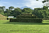
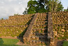
Multi-periodSite Name: IzapaCountry: Mexico Region: Chiapas Type: Ancient Village or Settlement
Nearest Town: Tapachula
Latitude: 14.923376N Longitude: 92.179942W
Condition:
| 5 | Perfect |
| 4 | Almost Perfect |
| 3 | Reasonable but with some damage |
| 2 | Ruined but still recognisable as an ancient site |
| 1 | Pretty much destroyed, possibly visible as crop marks |
| 0 | No data. |
| -1 | Completely destroyed |
| 5 | Superb |
| 4 | Good |
| 3 | Ordinary |
| 2 | Not Good |
| 1 | Awful |
| 0 | No data. |
| 5 | Can be driven to, probably with disabled access |
| 4 | Short walk on a footpath |
| 3 | Requiring a bit more of a walk |
| 2 | A long walk |
| 1 | In the middle of nowhere, a nightmare to find |
| 0 | No data. |
| 5 | co-ordinates taken by GPS or official recorded co-ordinates |
| 4 | co-ordinates scaled from a detailed map |
| 3 | co-ordinates scaled from a bad map |
| 2 | co-ordinates of the nearest village |
| 1 | co-ordinates of the nearest town |
| 0 | no data |
Internal Links:
External Links:
I have visited· I would like to visit
Andy B has visited here
")
More information at Mesoweb.
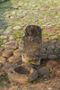
Note: Jaguar sculpture approximately 2000 years old found in Mexico
You may be viewing yesterday's version of this page. To see the most up to date information please register for a free account.
Do not use the above information on other web sites or publications without permission of the contributor.
Nearby Images from Flickr


The above images may not be of the site on this page, but were taken nearby. They are loaded from Flickr so please click on them for image credits.
Click here to see more info for this site
Nearby sites
Click here to view sites on an interactive map of the areaKey: Red: member's photo, Blue: 3rd party photo, Yellow: other image, Green: no photo - please go there and take one, Grey: site destroyed
Download sites to:
KML (Google Earth)
GPX (GPS waypoints)
CSV (Garmin/Navman)
CSV (Excel)
To unlock full downloads you need to sign up as a Contributory Member. Otherwise downloads are limited to 50 sites.
Turn off the page maps and other distractions
Nearby sites listing. In the following links * = Image available
23.2km W 262° Ojo de Agua Carving
57.6km ESE 124° Tak'alik Ab'aj* Ancient Village or Settlement
86.7km ENE 58° Zaculeu* Ancient Village or Settlement
89.5km NE 44° Tecumanchu* Ancient Temple
105.5km NNE 17° Lagartero Ancient Village or Settlement
107.4km ESE 104° Samabaj Ancient Temple
129.1km E 99° Iximche' * Ancient Village or Settlement
135.6km N 3° Tenam Puente* Ancient Village or Settlement
140.2km NNE 18° Chinkultic* Ancient Village or Settlement
151.5km NNE 24° Nuevo Ojo de Agua Cave Cave or Rock Shelter
178.5km E 100° Kaminaljuyu* Ancient Village or Settlement
181.1km ESE 101° Museum of Archaeology and Ethnology (Guatemala City)* Museum
216.6km NNW 336° Chiapa de Corzo Pyramid / Mastaba
216.6km NNW 336° Zoque Culture Archaeological Zone Ancient Village or Settlement
220.7km N 5° Tonina* Pyramid / Mastaba
228.3km NNE 25° Plan de Ayutla* Ancient Village or Settlement
231.5km NNE 31° Bonampak* Ancient Village or Settlement
255.3km NNE 30° Yaxchilan* Ancient Village or Settlement
256.8km NNE 27° Tecolote Ancient Village or Settlement
259.3km ENE 62° Cancuen* Ancient Village or Settlement
263.3km NE 50° Dos Pilas* Ancient Village or Settlement
267.4km NE 52° Aguateca* Ancient Village or Settlement
268.0km NNE 21° Piedras Negras* Ancient Village or Settlement
285.2km N 3° Palenque* Ancient Village or Settlement
287.5km NE 52° Ceibal* Ancient Village or Settlement
View more nearby sites and additional images


 We would like to know more about this location. Please feel free to add a brief description and any relevant information in your own language.
 Wir möchten mehr über diese Stätte erfahren. Bitte zögern Sie nicht, eine kurze Beschreibung und relevante Informationen in Deutsch hinzuzufügen.
 Nous aimerions en savoir encore un peu sur les lieux. S'il vous plaît n'hesitez pas à ajouter une courte description et tous les renseignements pertinents dans votre propre langue.
 Quisieramos informarnos un poco más de las lugares. No dude en añadir una breve descripción y otros datos relevantes en su propio idioma.