<< Our Photo Pages >> Miradouro Jurássico de Alqueidão da Serra - Modern Stone Circle etc in Portugal in Leiria
Submitted by Bak_teria on Friday, 31 July 2015 Page Views: 3158
Modern SitesSite Name: Miradouro Jurássico de Alqueidão da SerraCountry: Portugal
NOTE: This site is 15.065 km away from the location you searched for.
Distrito: Leiria Type: Modern Stone Circle etc
Nearest Town: Porto de Mós Nearest Village: Alqueidão da Serra
Latitude: 39.613717N Longitude: 8.761033W
Condition:
| 5 | Perfect |
| 4 | Almost Perfect |
| 3 | Reasonable but with some damage |
| 2 | Ruined but still recognisable as an ancient site |
| 1 | Pretty much destroyed, possibly visible as crop marks |
| 0 | No data. |
| -1 | Completely destroyed |
| 5 | Superb |
| 4 | Good |
| 3 | Ordinary |
| 2 | Not Good |
| 1 | Awful |
| 0 | No data. |
| 5 | Can be driven to, probably with disabled access |
| 4 | Short walk on a footpath |
| 3 | Requiring a bit more of a walk |
| 2 | A long walk |
| 1 | In the middle of nowhere, a nightmare to find |
| 0 | No data. |
| 5 | co-ordinates taken by GPS or official recorded co-ordinates |
| 4 | co-ordinates scaled from a detailed map |
| 3 | co-ordinates scaled from a bad map |
| 2 | co-ordinates of the nearest village |
| 1 | co-ordinates of the nearest town |
| 0 | no data |
Internal Links:
External Links:
I have visited· I would like to visit
Bak_teria visited on 26th Jul 2015 - their rating: Cond: 5 Amb: 5 Access: 5
")
This modern monument can easily be mistaken for an ancient megalithic enclosure and was erected on 27 and 28 of June of 1995. This interesting monument is the work of Ester Vieira, Francisco Furriel, Manuel António Gomes and several workers from local quarries, the viewpoint also brings together two large basalt elements, surrounded by the massive sedimentary limestone. The monument is a compliment to the times that brought to the region so many natural resources. From rocks to rivers, caves, flora and fauna, that enable nowadays to have a large number of industrial and tourist activities.
About the architecture
The viewpoint is composed of 15 limestone blocks representing the main periods of the Jurassic period. On-site is also made a reference to the time of the formation of the dominant rocks of Aire and Candeeiros mountains. At the center of the site there's an arch shaped structure that was also built with the limestone blocks.
About the location
The monument is located 500 meters above sea level, a place where the scenery is breathtaking, with a view that goes from Leiria and Porto de Mós castles to the Monastery of Batalha, even allowing you to catch a glimpse of the sea. Alqueidão da Serra is part of the county of Porto de Mós, located in the Leiria district. The access is identified with a plaque that points to the site. The route is made by a gravel road that leads to the wind farm on the top and can be easily done by car.
Links and information sources (all texts written in Portuguese):
- Webpage from the county of Porto de Mós
- Webpage from the non-oficial Blog of Alqueidão da Serra
You may be viewing yesterday's version of this page. To see the most up to date information please register for a free account.
")
")
")
Do not use the above information on other web sites or publications without permission of the contributor.
Nearby Images from Flickr
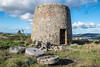
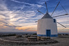

The above images may not be of the site on this page, but were taken nearby. They are loaded from Flickr so please click on them for image credits.
Click here to see more info for this site
Nearby sites
Click here to view sites on an interactive map of the areaKey: Red: member's photo, Blue: 3rd party photo, Yellow: other image, Green: no photo - please go there and take one, Grey: site destroyed
Download sites to:
KML (Google Earth)
GPX (GPS waypoints)
CSV (Garmin/Navman)
CSV (Excel)
To unlock full downloads you need to sign up as a Contributory Member. Otherwise downloads are limited to 50 sites.
Turn off the page maps and other distractions
Nearby sites listing. In the following links * = Image available
23.0km W 259° Estação Arqueológica de Parreitas Ancient Village or Settlement
24.9km SSW 209° Anta-Capela de Alcobertas* Burial Chamber or Dolmen
35.5km NNE 25° Anta do Alto da Carrasqueira* Burial Chamber or Dolmen
37.3km ENE 64° Complexo Megalítico do Rego da Murta* Burial Chamber or Dolmen
38.2km NE 51° Castro da Serra de Alvaiázere* Castro or Chafurdão
39.8km E 99° Anta de Vale da Lage* Burial Chamber or Dolmen
42.8km SW 230° Cidade Romana de Eburobritium Ancient Village or Settlement
43.6km ENE 64° Anthropomorphic Trapezoid Visigothic Grave* Rock Cut Tomb
43.9km SE 139° Menir de Ulme* Standing Stone (Menhir)
44.3km S 189° Castro de Vila Nova de São Pedro* Castro or Chafurdão
50.8km ESE 110° Antas da Jogada Burial Chamber or Dolmen
51.2km ESE 108° Menir de Vale dos Chãos Standing Stone (Menhir)
51.8km ESE 109° Mamoa do Alqueidão e Mendroa Round Barrow(s)
52.8km SSW 209° Castro de Pragança* Castro or Chafurdão
53.8km NNE 29° Villa Romana de Rabaçal Ancient Village or Settlement
58.7km NNE 23° Parque Arqueológico de Conimbriga* Ancient Village or Settlement
59.9km E 84° Castro de São Miguel de Amêndoa* Castro or Chafurdão
60.5km N 352° Museu Municipal Santos Rocha Museum
61.8km ESE 104° Anta da Casa dos Mouros* Burial Chamber or Dolmen
62.0km WSW 243° Gruta da Furninha* Cave or Rock Shelter
62.0km N 3° Necrópole do Ferrestelo Cist
62.0km N 3° Castro de Santa Olaia* Castro or Chafurdão
62.9km SW 229° Museu da Lourinhã* Museum
63.8km N 357° Anta das Carniçosas* Burial Chamber or Dolmen
64.6km ESE 103° Estação Arqueológica de Vale de Junco Ancient Village or Settlement
View more nearby sites and additional images


 We would like to know more about this location. Please feel free to add a brief description and any relevant information in your own language.
 Wir möchten mehr über diese Stätte erfahren. Bitte zögern Sie nicht, eine kurze Beschreibung und relevante Informationen in Deutsch hinzuzufügen.
 Nous aimerions en savoir encore un peu sur les lieux. S'il vous plaît n'hesitez pas à ajouter une courte description et tous les renseignements pertinents dans votre propre langue.
 Quisieramos informarnos un poco más de las lugares. No dude en añadir una breve descripción y otros datos relevantes en su propio idioma.