<< Our Photo Pages >> Cavaleiros Dolmen - Burial Chamber or Dolmen in Spain in Galicia
Submitted by MMG on Monday, 30 January 2006 Page Views: 4911
Neolithic and Bronze AgeSite Name: Cavaleiros Dolmen Alternative Name: Dolmen de Cabaleiros, Casa da Moura, Casa dos Mouros, Couza do CacheiroCountry: Spain
NOTE: This site is 2.57 km away from the location you searched for.
Region: Galicia Type: Burial Chamber or Dolmen
Nearest Town: La Coruña Nearest Village: Pontepedra
Latitude: 43.096876N Longitude: 8.550379W
Condition:
| 5 | Perfect |
| 4 | Almost Perfect |
| 3 | Reasonable but with some damage |
| 2 | Ruined but still recognisable as an ancient site |
| 1 | Pretty much destroyed, possibly visible as crop marks |
| 0 | No data. |
| -1 | Completely destroyed |
| 5 | Superb |
| 4 | Good |
| 3 | Ordinary |
| 2 | Not Good |
| 1 | Awful |
| 0 | No data. |
| 5 | Can be driven to, probably with disabled access |
| 4 | Short walk on a footpath |
| 3 | Requiring a bit more of a walk |
| 2 | A long walk |
| 1 | In the middle of nowhere, a nightmare to find |
| 0 | No data. |
| 5 | co-ordinates taken by GPS or official recorded co-ordinates |
| 4 | co-ordinates scaled from a detailed map |
| 3 | co-ordinates scaled from a bad map |
| 2 | co-ordinates of the nearest village |
| 1 | co-ordinates of the nearest town |
| 0 | no data |
Internal Links:
External Links:
I have visited· I would like to visit
DrewParsons would like to visit
")
For more details visit Megalitos.es.
You may be viewing yesterday's version of this page. To see the most up to date information please register for a free account.
")
Do not use the above information on other web sites or publications without permission of the contributor.
davidmorgan has found this location on Google Street View:
Nearby Images from Flickr
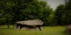
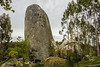
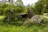
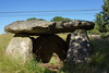

The above images may not be of the site on this page, but were taken nearby. They are loaded from Flickr so please click on them for image credits.
Click here to see more info for this site
Nearby sites
Click here to view sites on an interactive map of the areaKey: Red: member's photo, Blue: 3rd party photo, Yellow: other image, Green: no photo - please go there and take one, Grey: site destroyed
Download sites to:
KML (Google Earth)
GPX (GPS waypoints)
CSV (Garmin/Navman)
CSV (Excel)
To unlock full downloads you need to sign up as a Contributory Member. Otherwise downloads are limited to 50 sites.
Turn off the page maps and other distractions
Nearby sites listing. In the following links * = Image available
584m SSW 210° Castro de Bardaos Castro or Chafurdão
1.4km S 174° Castro de Cabaleiros Castro or Chafurdão
3.3km SSW 203° Castro de Castrillón (Tordioa) Castro or Chafurdão
7.1km NW 322° Dolmen de Pedra Moura (Carballo) Burial Chamber or Dolmen
7.1km S 180° Castro do Vilar Castro or Chafurdão
9.0km S 171° Castro de Francada Castro or Chafurdão
9.5km SSW 195° Castro de Lestrobe Castro or Chafurdão
12.6km SE 134° Castro de Trasmonte Castro or Chafurdão
12.7km SE 143° Castro de O Valo Castro or Chafurdão
13.4km S 187° Castro de Merelle Castro or Chafurdão
14.2km SSW 201° Castro do Castelo Castro or Chafurdão
14.3km SE 126° Castro de Bouzalonga Castro or Chafurdão
15.1km SSE 146° Castro de Vilacide Castro or Chafurdão
15.1km S 191° A Pedra que Fala Rock Art
15.3km SE 138° Castro de Vilalbarro Castro or Chafurdão
15.8km SSW 192° Castromaior (Lamascal) Castro or Chafurdão
15.8km SE 143° Castro de Oroso Pequeno Castro or Chafurdão
16.0km ESE 114° Castro do Recouso Castro or Chafurdão
16.2km SSW 207° Pedra do Home Necrópolis Barrow Cemetery
16.3km SSE 150° Castro da Corela Castro or Chafurdão
16.7km SSW 206° Castro de A Fontaiña Castro or Chafurdão
16.9km SE 133° Castro de Vilarromariz Castro or Chafurdão
17.0km S 191° Castro de Fontoade Castro or Chafurdão
17.1km N 351° Castro de Santa Baia Castro or Chafurdão
17.3km ENE 64° Castro das Travesas Castro or Chafurdão
View more nearby sites and additional images


 We would like to know more about this location. Please feel free to add a brief description and any relevant information in your own language.
 Wir möchten mehr über diese Stätte erfahren. Bitte zögern Sie nicht, eine kurze Beschreibung und relevante Informationen in Deutsch hinzuzufügen.
 Nous aimerions en savoir encore un peu sur les lieux. S'il vous plaît n'hesitez pas à ajouter une courte description et tous les renseignements pertinents dans votre propre langue.
 Quisieramos informarnos un poco más de las lugares. No dude en añadir una breve descripción y otros datos relevantes en su propio idioma.