<< Our Photo Pages >> Abul - Ancient Mine, Quarry or other Industry in Portugal in Setúbal
Submitted by Bak_teria on Tuesday, 06 October 2015 Page Views: 1691
Multi-periodSite Name: AbulCountry: Portugal
NOTE: This site is 19.364 km away from the location you searched for.
Distrito: Setúbal Type: Ancient Mine, Quarry or other Industry
Nearest Town: Alcácer do Sal Nearest Village: Alcácer do Sal
Latitude: 38.428332N Longitude: 8.681758W
Condition:
| 5 | Perfect |
| 4 | Almost Perfect |
| 3 | Reasonable but with some damage |
| 2 | Ruined but still recognisable as an ancient site |
| 1 | Pretty much destroyed, possibly visible as crop marks |
| 0 | No data. |
| -1 | Completely destroyed |
| 5 | Superb |
| 4 | Good |
| 3 | Ordinary |
| 2 | Not Good |
| 1 | Awful |
| 0 | No data. |
| 5 | Can be driven to, probably with disabled access |
| 4 | Short walk on a footpath |
| 3 | Requiring a bit more of a walk |
| 2 | A long walk |
| 1 | In the middle of nowhere, a nightmare to find |
| 0 | No data. |
| 5 | co-ordinates taken by GPS or official recorded co-ordinates |
| 4 | co-ordinates scaled from a detailed map |
| 3 | co-ordinates scaled from a bad map |
| 2 | co-ordinates of the nearest village |
| 1 | co-ordinates of the nearest town |
| 0 | no data |
Internal Links:
External Links:
I have visited· I would like to visit
BrunoG would like to visit
Bak_teria visited on 3rd Oct 2015 - their rating: Cond: 2 Amb: 4 Access: 2

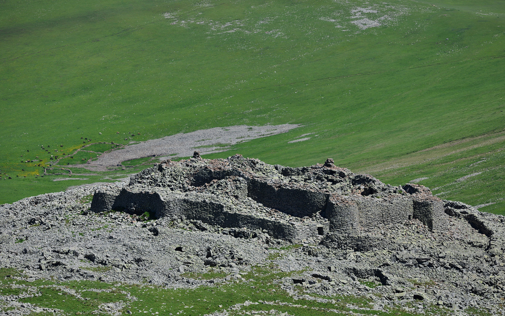
Abul was an original Phoenician industrial settlement built at the VII and VI century BC (Iron Age). Later it was also used by the Romans. At the beginning of the 1st century AD was also installed in the same place a furnace for producing a certain type of amphorae known as Dressel 14. This industrial production have been running until the mid 3rd century AD. This site was excavated during the last decade of the twentieth century in the Lower Sado area, between Alcacer do Sal and Setúbal, under a Portuguese-French program on fish salting industries from the Lower Sado. The site is classified as MN - Monumento Nacional (National Monument) and is located in a protection zone.
Although it has a protective status, this monument is pretty much abandoned.
About the two phases of occupation
The site was used as a natural port in a estuarine environment, endowed with conditions of anchorage and dry dock, allowing a port transit associable with the establishment of the Phoenician era. The advantages of the strategic position of the site made it also a good place for the industry of amphorae production in the Roman era.
In the first phase of occupation were built some wall lines with about 1.5m of maximum width, into which was acceded by a rectangular tower located west. All structures erected inside are in a rectangular shape and are organized around a central courtyard.
The second occupational phase will have elapsed from the need to expand the inner zone, carried out by dismantling the west and south side, while restricting the area of the central courtyard.
About the access
The access is open and can be made by car but only if you are ready to try some offroad. The best way to get to the site is going by foot but prepare yourself for a 4.5km walk. The rice fields are beautiful and the views from the river bank are stunning. Unfortunately the river is a little bit poluted and the vegetation has overtaken the Abul site.
Links and other information sources (texts written in Portuguese):
- DGPC
- Portal do Arqueólogo
You may be viewing yesterday's version of this page. To see the most up to date information please register for a free account.


Do not use the above information on other web sites or publications without permission of the contributor.
Click here to see more info for this site
Nearby sites
Click here to view sites on an interactive map of the areaKey: Red: member's photo, Blue: 3rd party photo, Yellow: other image, Green: no photo - please go there and take one, Grey: site destroyed
Download sites to:
KML (Google Earth)
GPX (GPS waypoints)
CSV (Garmin/Navman)
CSV (Excel)
To unlock full downloads you need to sign up as a Contributory Member. Otherwise downloads are limited to 50 sites.
Turn off the page maps and other distractions
Nearby sites listing. In the following links * = Image available
18.8km WNW 290° Cetóbriga Ancient Village or Settlement
25.5km NW 306° Castro de Chibanes* Castro or Chafurdão
26.3km NE 48° Anta da Flamenga Burial Chamber or Dolmen
27.0km NW 304° Grutas da Quinta do Anjo* Rock Cut Tomb
31.2km W 277° Monumento Megalítico da Roça do Casal do Meio* Chambered Tomb
31.6km ENE 66° Anta De Vale Da Asna 2 Burial Chamber or Dolmen
32.1km ENE 63° Anta De Vale Da Asna 1 Burial Chamber or Dolmen
34.9km S 186° Necrópole de Cistas das Casas Velhas* Cist
35.3km S 186° Dólmen da Pedra Branca* Burial Chamber or Dolmen
35.3km ENE 62° Anta Dos Castelos 1 Burial Chamber or Dolmen
39.1km ENE 76° Anta Do Tojal 1 Burial Chamber or Dolmen
39.7km ENE 75° Menir do Tojal* Standing Stone (Menhir)
40.0km ENE 75° Recinto Do Tojal* Stone Circle
40.1km ENE 75° Anta Da Quinta Do Gato 1* Burial Chamber or Dolmen
40.2km ENE 75° Sepultura Da Quinta Do Gato 2 Passage Grave
40.5km ENE 75° Anta Do Escoural 1 Burial Chamber or Dolmen
40.6km ENE 74° Sepultura Da Quinta Do Gato 4 Passage Grave
40.7km ENE 74° Sepultura Do Escoural 2 Passage Grave
40.9km ENE 74° Sepultura Do Escoural 3 Passage Grave
41.0km ENE 76° Anta Do Carapetal 1 Burial Chamber or Dolmen
41.2km ENE 76° Anta Do Carapetal 2 Burial Chamber or Dolmen
41.4km NE 56° Recinto Do Sideral* Stone Circle
41.7km NE 55° Cromeleque de Cuncos* Stone Circle
41.7km SSE 155° Anta da Pata do Cavalo* Burial Chamber or Dolmen
41.8km ENE 57° Menir Do Sideral Standing Stone (Menhir)
View more nearby sites and additional images


 We would like to know more about this location. Please feel free to add a brief description and any relevant information in your own language.
 Wir möchten mehr über diese Stätte erfahren. Bitte zögern Sie nicht, eine kurze Beschreibung und relevante Informationen in Deutsch hinzuzufügen.
 Nous aimerions en savoir encore un peu sur les lieux. S'il vous plaît n'hesitez pas à ajouter une courte description et tous les renseignements pertinents dans votre propre langue.
 Quisieramos informarnos un poco más de las lugares. No dude en añadir una breve descripción y otros datos relevantes en su propio idioma.