<< Our Photo Pages >> Sepulturas antropomórficas de Donões - Rock Cut Tomb in Portugal in Vila Real
Submitted by Alta-Falisa on Sunday, 09 August 2015 Page Views: 2866
Multi-periodSite Name: Sepulturas antropomórficas de Donões Alternative Name: Necrópole medieval de Santo Amaro.Country: Portugal Distrito: Vila Real Type: Rock Cut Tomb
Nearest Town: Montalegre
Latitude: 41.827300N Longitude: 7.8247W
Condition:
| 5 | Perfect |
| 4 | Almost Perfect |
| 3 | Reasonable but with some damage |
| 2 | Ruined but still recognisable as an ancient site |
| 1 | Pretty much destroyed, possibly visible as crop marks |
| 0 | No data. |
| -1 | Completely destroyed |
| 5 | Superb |
| 4 | Good |
| 3 | Ordinary |
| 2 | Not Good |
| 1 | Awful |
| 0 | No data. |
| 5 | Can be driven to, probably with disabled access |
| 4 | Short walk on a footpath |
| 3 | Requiring a bit more of a walk |
| 2 | A long walk |
| 1 | In the middle of nowhere, a nightmare to find |
| 0 | No data. |
| 5 | co-ordinates taken by GPS or official recorded co-ordinates |
| 4 | co-ordinates scaled from a detailed map |
| 3 | co-ordinates scaled from a bad map |
| 2 | co-ordinates of the nearest village |
| 1 | co-ordinates of the nearest town |
| 0 | no data |
Internal Links:
External Links:
")
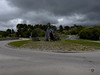
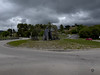
The sepulturas are arranged in two groups.
The first you see are on the Southern side of the chapel, four rather well preserved sepulturas ;
on the North of the chapel, there are two more (non vidi), one well preserved while the other is partially destroyed.
One may fear the the chapel is built on more such 'sepulturas'.
March 2014.
Signposted Sepulturas antropomórficas about 1 km West of Montalegre, at a T-junction along road M.308, exactly at (41.8229,-7.8128).
Signposted again along road M.510 at a Y-junction (41.8279,-7.8141), from where you drive 1 km uphill up to Capela de Santo Amaro. Easy access by car.
You may be viewing yesterday's version of this page. To see the most up to date information please register for a free account.
")
")
")
")
Do not use the above information on other web sites or publications without permission of the contributor.
Nearby Images from Flickr


The above images may not be of the site on this page, but were taken nearby. They are loaded from Flickr so please click on them for image credits.
Click here to see more info for this site
Nearby sites
Click here to view sites on an interactive map of the areaKey: Red: member's photo, Blue: 3rd party photo, Yellow: other image, Green: no photo - please go there and take one, Grey: site destroyed
Download sites to:
KML (Google Earth)
GPX (GPS waypoints)
CSV (Garmin/Navman)
CSV (Excel)
To unlock full downloads you need to sign up as a Contributory Member. Otherwise downloads are limited to 50 sites.
Turn off the page maps and other distractions
Nearby sites listing. In the following links * = Image available
2.6km E 99° Mamoas da Veiga Round Barrow(s)
3.4km ENE 62° Sepulturas antropomórficas de Santo Adrião* Rock Cut Tomb
4.6km ENE 78° Montalegre* Modern Stone Circle etc
8.0km SSW 203° Castro de São Romão Castro or Chafurdão
13.3km NW 324° Necrópole de Outeiro de Cavaladre* Burial Chamber or Dolmen
13.7km ESE 103° Castro do Pedrário Castro or Chafurdão
14.3km NW 315° Casola do Foxo* Burial Chamber or Dolmen
14.8km ENE 61° Castro da Xironda Castro or Chafurdão
14.8km NW 319° Casiña da Moura* Burial Chamber or Dolmen
17.8km SE 146° Castro de Carvalhelhos Castro or Chafurdão
20.0km NE 55° Castro de Saceda* Castro or Chafurdão
20.2km SSE 159° Castro de Lesenho Castro or Chafurdão
20.2km ENE 69° Castro de San Millao Castro or Chafurdão
20.7km SE 135° Castro de Cabeço Castro or Chafurdão
20.8km NW 322° Aquis Querquennis Campamento Romano* Ancient Village or Settlement
20.8km NW 320° Pedrafita en Aquis Querquernis Standing Stone (Menhir)
21.0km SSE 164° Castro Outeiro Lesenho* Castro or Chafurdão
22.1km S 184° Castro da Giestosa Castro or Chafurdão
23.6km W 278° Aquis Originis Ancient Village or Settlement
24.6km NE 56° Petróglifos Penedo do Muro Rock Art
25.4km W 266° Portela do Homem* Modern Stone Circle etc
26.3km NE 49° Castro de Lucenza Castro or Chafurdão
27.3km NNE 18° Castro da Cidade Castro or Chafurdão
29.3km ENE 70° Petróglifos das Chás Rock Art
30.4km NW 307° Casa da Moura Dolmen (A Gurita)* Burial Chamber or Dolmen
View more nearby sites and additional images


 We would like to know more about this location. Please feel free to add a brief description and any relevant information in your own language.
 Wir möchten mehr über diese Stätte erfahren. Bitte zögern Sie nicht, eine kurze Beschreibung und relevante Informationen in Deutsch hinzuzufügen.
 Nous aimerions en savoir encore un peu sur les lieux. S'il vous plaît n'hesitez pas à ajouter une courte description et tous les renseignements pertinents dans votre propre langue.
 Quisieramos informarnos un poco más de las lugares. No dude en añadir una breve descripción y otros datos relevantes en su propio idioma.