<< Our Photo Pages >> Stone house Pichasca - Ancient Village or Settlement in Chile
Submitted by KaiHofmann on Saturday, 28 June 2014 Page Views: 6728
Multi-periodSite Name: Stone house Pichasca Alternative Name: M.N. Pichasca bosque petrificado, San Pedro Viejo de PichascaCountry: Chile
NOTE: This site is 106.656 km away from the location you searched for.
Type: Ancient Village or Settlement
Nearest Town: Ovalle Nearest Village: Pichasca
Latitude: 30.391849S Longitude: 70.885232W
Condition:
| 5 | Perfect |
| 4 | Almost Perfect |
| 3 | Reasonable but with some damage |
| 2 | Ruined but still recognisable as an ancient site |
| 1 | Pretty much destroyed, possibly visible as crop marks |
| 0 | No data. |
| -1 | Completely destroyed |
| 5 | Superb |
| 4 | Good |
| 3 | Ordinary |
| 2 | Not Good |
| 1 | Awful |
| 0 | No data. |
| 5 | Can be driven to, probably with disabled access |
| 4 | Short walk on a footpath |
| 3 | Requiring a bit more of a walk |
| 2 | A long walk |
| 1 | In the middle of nowhere, a nightmare to find |
| 0 | No data. |
| 5 | co-ordinates taken by GPS or official recorded co-ordinates |
| 4 | co-ordinates scaled from a detailed map |
| 3 | co-ordinates scaled from a bad map |
| 2 | co-ordinates of the nearest village |
| 1 | co-ordinates of the nearest town |
| 0 | no data |
Internal Links:
External Links:
")
Nearby is a Petrified Forest.
Note: Study of pictographs within San Pedro Viejo de Pichasca rock-shelter, Chile records geometric linear motifs, curvilinear patterns and hand prints
You may be viewing yesterday's version of this page. To see the most up to date information please register for a free account.
")
Do not use the above information on other web sites or publications without permission of the contributor.
Nearby Images from Flickr
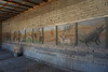
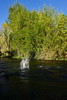
The above images may not be of the site on this page, but were taken nearby. They are loaded from Flickr so please click on them for image credits.
Click here to see more info for this site
Nearby sites
Click here to view sites on an interactive map of the areaKey: Red: member's photo, Blue: 3rd party photo, Yellow: other image, Green: no photo - please go there and take one, Grey: site destroyed
Download sites to:
KML (Google Earth)
GPX (GPS waypoints)
CSV (Garmin/Navman)
CSV (Excel)
To unlock full downloads you need to sign up as a Contributory Member. Otherwise downloads are limited to 50 sites.
Turn off the page maps and other distractions
Nearby sites listing. In the following links * = Image available
4.7km SW 230° Petroglifos de las Tinajas* Rock Art
58.6km SW 234° Valle del Encanto* Rock Art
64.5km NNW 327° Archaeological Museum of La Serena* Museum
126.3km N 7° Los petroglifos del Cerro La Silla Rock Art
191.6km S 188° Los petroglifos Tilama* Rock Art
339.6km S 176° Museo Chileno de Arte Precolombino de Santiago de Chile* Museum
339.7km S 177° Museo Nacional de Historia Natural, MNHN* Museum
341.0km S 176° Parque Almagro* Modern Stone Circle etc
469.3km NE 51° El Shincal Ancient Village or Settlement
578.9km N 11° San Ramon 15 Ancient Mine, Quarry or other Industry
626.9km NE 50° Fuerte Quemado* Ancient Village or Settlement
634.1km NE 54° Tafi del Valle* Sculptured Stone
643.5km NE 50° Museo Pachamama* Museum
644.4km NE 49° Los Quilmes* Ancient Village or Settlement
673.3km NNE 21° Llullaillaco Vault Chambered Tomb
748.0km NE 40° Archaeological Museum Pío Pablo Díaz* Museum
748.5km NE 39° Mariscal Ancient Village or Settlement
749.1km NE 39° Bogatta Ancient Village or Settlement
781.0km NE 39° Potrero de Payogasta* Ancient Village or Settlement
823.9km NE 42° MAAM* Museum
866.2km NNE 18° Tulor Ancient Village or Settlement
873.9km NNE 18° R. P. Gustavo Le Paige Archaeological Museum* Museum
874.1km NNE 18° Pucara de Quitor* Stone Fort or Dun
897.4km NNE 18° Petroglifos Yerbas Buenas* Rock Art
916.8km NNE 32° Barrancas Rock Art
View more nearby sites and additional images


 We would like to know more about this location. Please feel free to add a brief description and any relevant information in your own language.
 Wir möchten mehr über diese Stätte erfahren. Bitte zögern Sie nicht, eine kurze Beschreibung und relevante Informationen in Deutsch hinzuzufügen.
 Nous aimerions en savoir encore un peu sur les lieux. S'il vous plaît n'hesitez pas à ajouter une courte description et tous les renseignements pertinents dans votre propre langue.
 Quisieramos informarnos un poco más de las lugares. No dude en añadir una breve descripción y otros datos relevantes en su propio idioma.