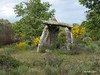
<< Text Pages >> Anta da Pedra de Anta - Burial Chamber or Dolmen in Portugal in Guarda
Submitted by AlexHunger on Monday, 29 May 2006 Page Views: 3521
Neolithic and Bronze AgeSite Name: Anta da Pedra de Anta Alternative Name: Anta da Malhada SordaCountry: Portugal
NOTE: This site is 10.067 km away from the location you searched for.
Distrito: Guarda Type: Burial Chamber or Dolmen
Nearest Town: Guarda Nearest Village: Almeida
Latitude: 40.511058N Longitude: 6.880315W
Condition:
| 5 | Perfect |
| 4 | Almost Perfect |
| 3 | Reasonable but with some damage |
| 2 | Ruined but still recognisable as an ancient site |
| 1 | Pretty much destroyed, possibly visible as crop marks |
| 0 | No data. |
| -1 | Completely destroyed |
| 5 | Superb |
| 4 | Good |
| 3 | Ordinary |
| 2 | Not Good |
| 1 | Awful |
| 0 | No data. |
| 5 | Can be driven to, probably with disabled access |
| 4 | Short walk on a footpath |
| 3 | Requiring a bit more of a walk |
| 2 | A long walk |
| 1 | In the middle of nowhere, a nightmare to find |
| 0 | No data. |
| 5 | co-ordinates taken by GPS or official recorded co-ordinates |
| 4 | co-ordinates scaled from a detailed map |
| 3 | co-ordinates scaled from a bad map |
| 2 | co-ordinates of the nearest village |
| 1 | co-ordinates of the nearest town |
| 0 | no data |
Internal Links:
External Links:
Burial Chamber (Dolmen) in Central Portugal
Distrito da Guarda, area of Malhada Sorda
You may be viewing yesterday's version of this page. To see the most up to date information please register for a free account.
Do not use the above information on other web sites or publications without permission of the contributor.
Nearby Images from Flickr
The above images may not be of the site on this page, but were taken nearby. They are loaded from Flickr so please click on them for image credits.
Click here to see more info for this site
Nearby sites
Click here to view sites on an interactive map of the areaKey: Red: member's photo, Blue: 3rd party photo, Yellow: other image, Green: no photo - please go there and take one, Grey: site destroyed
Download sites to:
KML (Google Earth)
GPX (GPS waypoints)
CSV (Garmin/Navman)
CSV (Excel)
To unlock full downloads you need to sign up as a Contributory Member. Otherwise downloads are limited to 50 sites.
Turn off the page maps and other distractions
Nearby sites listing. In the following links * = Image available
12.5km N 351° Piedra Caballero en Castelo Bom* Natural Stone / Erratic / Other Natural Feature
17.7km W 272° Menires de Rochoso* Standing Stones
17.7km W 267° Sepultura antropomórfica de Rochoso* Rock Cut Tomb
21.6km WNW 290° Castro do Jarmelo Castro or Chafurdão
25.2km SW 226° Museu do Sabugal* Museum
27.8km NE 42° Siega Verde* Rock Art
28.5km N 359° Necrópole de sepulturas escavadas na rocha em Malpartida* Rock Cut Tomb
29.7km WNW 296° Anta de Pêra do Moço* Burial Chamber or Dolmen
32.0km W 277° Nossa Senhora da Póvoa de Mileu Ancient Village or Settlement
36.7km W 279° Castro de Tintinolho Castro or Chafurdão
36.8km S 187° El Palancar Burial Chamber or Dolmen
37.0km NNW 344° Povoação do Colmeal Castro or Chafurdão
37.8km ENE 73° La Rábida Burial Chamber or Dolmen
41.2km W 265° Sepulturas antropomórficas de la Ermida de Nª Sª de Soito* Rock Cut Tomb
41.8km WSW 249° Torre de Centum Cellas Ancient Village or Settlement
43.3km WSW 247° Castro da Chandeirinha de Belmonte Castro or Chafurdão
44.6km NNE 14° Pena del Perdon Castro or Chafurdão
44.7km ESE 112° Castillo Petroglifos Erias Rock Art
44.9km WSW 244° Villa Romana da Fórnea Ancient Village or Settlement
45.6km SE 135° El Maton Burial Chamber or Dolmen
45.6km S 186° Salvaleon Castro or Chafurdão
46.1km NNE 12° Los Pedazos de la Mata Burial Chamber or Dolmen
46.5km WNW 290° Estação arqueólogica de São Gens* Rock Cut Tomb
47.6km WSW 241° Anta da Rotunda de Caria* Modern Stone Circle etc
47.8km SE 133° Dehesa 2 Burial Chamber or Dolmen
View more nearby sites and additional images


 We would like to know more about this location. Please feel free to add a brief description and any relevant information in your own language.
 Wir möchten mehr über diese Stätte erfahren. Bitte zögern Sie nicht, eine kurze Beschreibung und relevante Informationen in Deutsch hinzuzufügen.
 Nous aimerions en savoir encore un peu sur les lieux. S'il vous plaît n'hesitez pas à ajouter une courte description et tous les renseignements pertinents dans votre propre langue.
 Quisieramos informarnos un poco más de las lugares. No dude en añadir una breve descripción y otros datos relevantes en su propio idioma.