<< Our Photo Pages >> Knocknagin - Passage Grave in Ireland (Republic of) in Co. Meath
Submitted by ainsloch on Sunday, 24 May 2015 Page Views: 2162
Neolithic and Bronze AgeSite Name: Knocknagin Alternative Name: GormanstownCountry: Ireland (Republic of)
NOTE: This site is 5.121 km away from the location you searched for.
County: Co. Meath Type: Passage Grave
Nearest Village: Gormanstown
Latitude: 53.634550N Longitude: 6.217099W
Condition:
| 5 | Perfect |
| 4 | Almost Perfect |
| 3 | Reasonable but with some damage |
| 2 | Ruined but still recognisable as an ancient site |
| 1 | Pretty much destroyed, possibly visible as crop marks |
| 0 | No data. |
| -1 | Completely destroyed |
| 5 | Superb |
| 4 | Good |
| 3 | Ordinary |
| 2 | Not Good |
| 1 | Awful |
| 0 | No data. |
| 5 | Can be driven to, probably with disabled access |
| 4 | Short walk on a footpath |
| 3 | Requiring a bit more of a walk |
| 2 | A long walk |
| 1 | In the middle of nowhere, a nightmare to find |
| 0 | No data. |
| 5 | co-ordinates taken by GPS or official recorded co-ordinates |
| 4 | co-ordinates scaled from a detailed map |
| 3 | co-ordinates scaled from a bad map |
| 2 | co-ordinates of the nearest village |
| 1 | co-ordinates of the nearest town |
| 0 | no data |
Internal Links:
External Links:
")
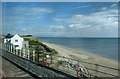
Other monuments which existed nearby have fallen from their positions atop a ledge down onto Knocknagin beach, as the encroaching sea erodes the cliffs along the coast. Little now remains of them except for some clusters of boulders amidst the sand.
About a mile to the east on the opposite side of the River Delvin is found the Bremore passage grave complex, which consisted of at least five monuments. Altogether this was a region of particular significance whose monuments are thought to predate the major Boyne Valley passage mounds. They are perhaps contemporary with the Carrowmore or Carrowkeel complexes in Co. Sligo.
You may be viewing yesterday's version of this page. To see the most up to date information please register for a free account.
Do not use the above information on other web sites or publications without permission of the contributor.
Nearby Images from Geograph Britain and Ireland:
©2015(licence)
©2008(licence)
©2007(licence)
©2011(licence)
©2013(licence)
The above images may not be of the site on this page, they are loaded from Geograph.
Please Submit an Image of this site or go out and take one for us!
Click here to see more info for this site
Nearby sites
Click here to view sites on an interactive map of the areaKey: Red: member's photo, Blue: 3rd party photo, Yellow: other image, Green: no photo - please go there and take one, Grey: site destroyed
Download sites to:
KML (Google Earth)
GPX (GPS waypoints)
CSV (Garmin/Navman)
CSV (Excel)
To unlock full downloads you need to sign up as a Contributory Member. Otherwise downloads are limited to 50 sites.
Turn off the page maps and other distractions
Nearby sites listing. In the following links * = Image available
1.8km ESE 105° Bremore Port* Passage Grave
7.5km WSW 250° Greenanstown Stone Circle (O110637)
8.3km WSW 247° Micknanstown* Passage Grave
8.4km WSW 240° Fourknocks* Passage Grave (O10856202)
10.9km ESE 120° St Patrick's Island Early Christian Sculptured Stone
12.2km NW 315° Millmount* Artificial Mound
12.2km NNW 345° Baltray* Standing Stones
15.3km NW 308° Oldbridge Logboat, River Boyne Not Known (by us)
16.2km WNW 297° Donore Mystery Mound Artificial Mound (O0334573550)
16.5km WNW 300° Dowth Henge* Henge (O034742)
16.7km WNW 298° Dowth Hall* Passage Grave
17.2km WNW 297° Dowth Passage Grave* Passage Grave (O02377377)
17.4km WNW 292° Newgrange Standing Stones* Standing Stones
17.8km WNW 291° Newgrange Barrow ME019-049001* Chambered Tomb (SB0500930882)
18.2km WSW 242° Kilbrew Henge
18.2km WNW 302° Townleyhall Passage Tomb* Passage Grave (O0222075723)
18.3km WNW 292° Newgrange* Passage Grave (O00747272)
18.3km WNW 291° Newgrange Stone Circle* Stone Circle (O007727)
18.3km WNW 289° Recently Discovered Prehistoric Cropmark near Newgrange* Misc. Earthwork
19.5km WNW 292° Knowth Timber Circle* Timber Circle (N997734)
19.5km WNW 292° Knowth* Passage Grave (N99697342)
20.6km NW 320° Muiredach's Cross (Monasterboice)* Ancient Cross (O044820)
23.5km WNW 293° Hill of Slane* Artificial Mound
23.6km WSW 245° Moyer Carns Cairn
24.4km S 174° St Doulagh's Holy Well (Balgriffin) Holy Well or Sacred Spring (SG2230999210)
View more nearby sites and additional images


 We would like to know more about this location. Please feel free to add a brief description and any relevant information in your own language.
 Wir möchten mehr über diese Stätte erfahren. Bitte zögern Sie nicht, eine kurze Beschreibung und relevante Informationen in Deutsch hinzuzufügen.
 Nous aimerions en savoir encore un peu sur les lieux. S'il vous plaît n'hesitez pas à ajouter une courte description et tous les renseignements pertinents dans votre propre langue.
 Quisieramos informarnos un poco más de las lugares. No dude en añadir una breve descripción y otros datos relevantes en su propio idioma.