

<< Our Photo Pages >> Tafi del Valle - Sculptured Stone in Argentina
Submitted by durhamnature on Tuesday, 29 January 2013 Page Views: 7368
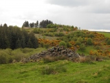
Multi-periodSite Name: Tafi del Valle Alternative Name: Los Menhires Archaeological ReserveCountry: Argentina Type: Sculptured Stone
Nearest Town: Tucuman Nearest Village: El Mollar
Latitude: 26.939649S Longitude: 65.710109W
Condition:
| 5 | Perfect |
| 4 | Almost Perfect |
| 3 | Reasonable but with some damage |
| 2 | Ruined but still recognisable as an ancient site |
| 1 | Pretty much destroyed, possibly visible as crop marks |
| 0 | No data. |
| -1 | Completely destroyed |
| 5 | Superb |
| 4 | Good |
| 3 | Ordinary |
| 2 | Not Good |
| 1 | Awful |
| 0 | No data. |
| 5 | Can be driven to, probably with disabled access |
| 4 | Short walk on a footpath |
| 3 | Requiring a bit more of a walk |
| 2 | A long walk |
| 1 | In the middle of nowhere, a nightmare to find |
| 0 | No data. |
| 5 | co-ordinates taken by GPS or official recorded co-ordinates |
| 4 | co-ordinates scaled from a detailed map |
| 3 | co-ordinates scaled from a bad map |
| 2 | co-ordinates of the nearest village |
| 1 | co-ordinates of the nearest town |
| 0 | no data |
Internal Links:
External Links:
I have visited· I would like to visit
DrewParsons has visited here
")
Los Menhires Archaeological Reserve is a venue containing over 50 megaliths of the Tafí 1 culture, which dates back to the period between 820 BCE and 780 CE.
More information at www.welcomeargentina.com
You may be viewing yesterday's version of this page. To see the most up to date information please register for a free account.
")
")
")
")
")
")
")
")
")
")
")
")
")
")
")
Do not use the above information on other web sites or publications without permission of the contributor.
Click here to see more info for this site
Nearby sites
Click here to view sites on an interactive map of the areaKey: Red: member's photo, Blue: 3rd party photo, Yellow: other image, Green: no photo - please go there and take one, Grey: site destroyed
Download sites to:
KML (Google Earth)
GPX (GPS waypoints)
CSV (Garmin/Navman)
CSV (Excel)
To unlock full downloads you need to sign up as a Contributory Member. Otherwise downloads are limited to 50 sites.
Turn off the page maps and other distractions
Nearby sites listing. In the following links * = Image available
44.3km NNW 332° Museo Pachamama* Museum
46.4km NW 311° Fuerte Quemado* Ancient Village or Settlement
62.0km NNW 328° Los Quilmes* Ancient Village or Settlement
167.2km WSW 240° El Shincal Ancient Village or Settlement
207.3km NNW 347° Archaeological Museum Pío Pablo Díaz* Museum
208.4km NNW 347° Mariscal Ancient Village or Settlement
211.5km NNW 347° Bogatta Ancient Village or Settlement
237.2km N 352° Potrero de Payogasta* Ancient Village or Settlement
241.0km N 7° MAAM* Museum
374.1km N 5° Pucará de Tilcara* Ancient Village or Settlement
377.6km NW 311° Llullaillaco Vault Chambered Tomb
382.0km N 5° Pucará de Juella Hillfort
385.2km N 5° Pucará del Angosto de Perchel Hillfort
387.3km N 6° La Huerta Ancient Village or Settlement
393.1km N 5° Pucará de Campo Morado Hillfort
398.3km N 5° Pucará de Yacoraite Hillfort
399.5km N 5° Los Armarillos Ancient Village or Settlement
417.6km N 5° Pucará de Peñas Blancas Hillfort
423.8km N 6° Coctaca Ancient Village or Settlement
445.3km WNW 294° San Ramon 15 Ancient Mine, Quarry or other Industry
510.1km NNW 329° Tulor Ancient Village or Settlement
513.9km NNW 330° R. P. Gustavo Le Paige Archaeological Museum* Museum
515.4km NNW 330° Pucara de Quitor* Stone Fort or Dun
538.3km NNW 331° Petroglifos Yerbas Buenas* Rock Art
555.3km WSW 241° Los petroglifos del Cerro La Silla Rock Art
View more nearby sites and additional images


 We would like to know more about this location. Please feel free to add a brief description and any relevant information in your own language.
 Wir möchten mehr über diese Stätte erfahren. Bitte zögern Sie nicht, eine kurze Beschreibung und relevante Informationen in Deutsch hinzuzufügen.
 Nous aimerions en savoir encore un peu sur les lieux. S'il vous plaît n'hesitez pas à ajouter une courte description et tous les renseignements pertinents dans votre propre langue.
 Quisieramos informarnos un poco más de las lugares. No dude en añadir una breve descripción y otros datos relevantes en su propio idioma.