<< Our Photo Pages >> Loch Achaidh na h-Inich - Crannog in Scotland in Highlands
Submitted by uisdean on Monday, 30 June 2008 Page Views: 8619
Iron Age and Later PrehistorySite Name: Loch Achaidh na h-Inich Alternative Name: Loch Ach-an-darrachCountry: Scotland
NOTE: This site is 3.371 km away from the location you searched for.
County: Highlands Type: Crannog
Nearest Village: Plocton
Map Ref: NG81173095
Latitude: 57.316462N Longitude: 5.635714W
Condition:
| 5 | Perfect |
| 4 | Almost Perfect |
| 3 | Reasonable but with some damage |
| 2 | Ruined but still recognisable as an ancient site |
| 1 | Pretty much destroyed, possibly visible as crop marks |
| 0 | No data. |
| -1 | Completely destroyed |
| 5 | Superb |
| 4 | Good |
| 3 | Ordinary |
| 2 | Not Good |
| 1 | Awful |
| 0 | No data. |
| 5 | Can be driven to, probably with disabled access |
| 4 | Short walk on a footpath |
| 3 | Requiring a bit more of a walk |
| 2 | A long walk |
| 1 | In the middle of nowhere, a nightmare to find |
| 0 | No data. |
| 5 | co-ordinates taken by GPS or official recorded co-ordinates |
| 4 | co-ordinates scaled from a detailed map |
| 3 | co-ordinates scaled from a bad map |
| 2 | co-ordinates of the nearest village |
| 1 | co-ordinates of the nearest town |
| 0 | no data |
Internal Links:
External Links:
")
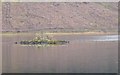
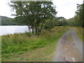
The Canmore database notes that there are two crannogs in this loch; only one was visible above the waterline in June 2008. It is a small stone structure, on which a cairn has been built. A survey of the two crannogs in 2003 by M Wildgoose found loose worked timbers on the floor of the loch.
You may be viewing yesterday's version of this page. To see the most up to date information please register for a free account.
")
Do not use the above information on other web sites or publications without permission of the contributor.
coldrum has found this location on Google Street View:
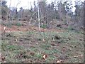
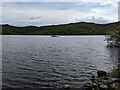
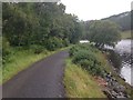
Nearby Images from Geograph Britain and Ireland:
©2006(licence)
©2023(licence)
©2014(licence)
©2006(licence)
©2009(licence)
The above images may not be of the site on this page, they are loaded from Geograph.
Please Submit an Image of this site or go out and take one for us!
Click here to see more info for this site
Nearby sites
Key: Red: member's photo, Blue: 3rd party photo, Yellow: other image, Green: no photo - please go there and take one, Grey: site destroyed
Download sites to:
KML (Google Earth)
GPX (GPS waypoints)
CSV (Garmin/Navman)
CSV (Excel)
To unlock full downloads you need to sign up as a Contributory Member. Otherwise downloads are limited to 50 sites.
Turn off the page maps and other distractions
Nearby sites listing. In the following links * = Image available
880m NE 52° Carn na Sean-chreige* Hillfort (NG81893146)
3.6km SSE 152° Dun Kirkton Stone Fort or Dun (NG82722768)
4.0km SSE 148° Angels' Hill, Kirkton* Hillfort (NG83142745)
4.0km SSE 148° Lochalsh* Stone Circle (NG831274)
4.2km ESE 108° Gleann Udalain Cairn Cairn (NG85092942)
5.0km SE 127° Dun Gleann Udalain Stone Fort or Dun (NG85062773)
8.0km SE 132° Dun Totaig (Loch Duich) Broch or Nuraghe (NG868253)
8.0km SE 134° Caisteal Grugaig* Broch or Nuraghe (NG86692508)
8.4km SE 129° Totaig Cup Markings* Rock Art (NG87432536)
8.4km WSW 243° Sligeanach Kildonan Stone Row / Alignment (NG735275)
9.1km ESE 106° Bard's Castle* Hillfort (NG89822790)
9.8km NNE 11° Lag An Duin Broch or Nuraghe (NG83624044)
9.9km S 181° Bernera Farm* Rock Art (NG80552110)
10.2km S 171° Am Baghan Galldair* Stone Fort or Dun (NG82162075)
10.7km SE 135° Torran a'Bharraich* Hillfort (NG88312296)
10.7km SE 124° Carr Brae* Rock Art (NG89782451)
11.1km SE 133° Allt an Inbhir Souterrain* Souterrain (Fogou, Earth House) (NG88882296)
11.3km SSE 158° Serpent Mound (Scallasaig) Cairn (NG8484020288)
11.3km S 171° An Dun (Barnhill)* Stone Fort or Dun (NG82441972)
12.5km NW 304° Toscaig (Applecross) Standing Stones (NG712385)
13.4km E 95° Camas Luinie* Rock Art (NG94492909)
13.8km S 169° Corrary Prehistoric Site* Cairn (NG83121725)
13.8km S 170° Dun Telve* Broch or Nuraghe (NG829172)
13.9km SSE 168° Dun Troddan* Broch or Nuraghe (NG834172)
14.1km WSW 239° Tobar Ashik* Holy Well or Sacred Spring (NG6873324291)
View more nearby sites and additional images


 We would like to know more about this location. Please feel free to add a brief description and any relevant information in your own language.
 Wir möchten mehr über diese Stätte erfahren. Bitte zögern Sie nicht, eine kurze Beschreibung und relevante Informationen in Deutsch hinzuzufügen.
 Nous aimerions en savoir encore un peu sur les lieux. S'il vous plaît n'hesitez pas à ajouter une courte description et tous les renseignements pertinents dans votre propre langue.
 Quisieramos informarnos un poco más de las lugares. No dude en añadir una breve descripción y otros datos relevantes en su propio idioma.