


<< Our Photo Pages >> Mary's Well (Illogan) - Holy Well or Sacred Spring in England in Cornwall
Submitted by LiveAndrew on Friday, 26 March 2021 Page Views: 1338
Springs and Holy WellsSite Name: Mary's Well (Illogan)Country: England County: Cornwall Type: Holy Well or Sacred Spring
Nearest Town: Redruth Nearest Village: Illogan
Map Ref: SW66484369
Latitude: 50.246949N Longitude: 5.276784W
Condition:
| 5 | Perfect |
| 4 | Almost Perfect |
| 3 | Reasonable but with some damage |
| 2 | Ruined but still recognisable as an ancient site |
| 1 | Pretty much destroyed, possibly visible as crop marks |
| 0 | No data. |
| -1 | Completely destroyed |
| 5 | Superb |
| 4 | Good |
| 3 | Ordinary |
| 2 | Not Good |
| 1 | Awful |
| 0 | No data. |
| 5 | Can be driven to, probably with disabled access |
| 4 | Short walk on a footpath |
| 3 | Requiring a bit more of a walk |
| 2 | A long walk |
| 1 | In the middle of nowhere, a nightmare to find |
| 0 | No data. |
| 5 | co-ordinates taken by GPS or official recorded co-ordinates |
| 4 | co-ordinates scaled from a detailed map |
| 3 | co-ordinates scaled from a bad map |
| 2 | co-ordinates of the nearest village |
| 1 | co-ordinates of the nearest town |
| 0 | no data |
Internal Links:
External Links:
I have visited· I would like to visit
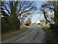
LiveAndrew visited on 25th Mar 2021 - their rating: Cond: 5 Amb: 2 Access: 5 Driven past this Well so many times
 (PID:224935)")
HER Number: 18159
Name: ILLOGAN - Medieval holy well, Post Medieval holy well
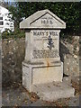
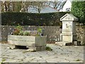
"The site of a holy well, now marked by a small garden with drinking fountain structure dated 1888."
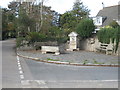
"This location beside a cross roads, is said by local people to have been the site of a holy well. It is now marked by a small garden with drinking fountain structure dated 1888, built by the Basset family (h1, b1). The feature marked 'W' and 'Trough' on the OS maps is presumably this latter (b2). The feature is now shown as Mary's Well by the OS.
(b1) - Budd, M, 1982, Pers Comm
(b2) - Preston-Jones, A, 198-, Pers Comm"
The inscription on the granite dressing reads: "June 21st 1888. Mary's Well. Given by Gustavus Bassett. Jesus said Whosoever drinketh of this water shall thirst again. But whoever drinketh of the water that I shall give him shall never thirst. But the water that I shall give him shall be in him a well of water springing up into everlasting life."
You may be viewing yesterday's version of this page. To see the most up to date information please register for a free account.
 (PID:224934)")
 (PID:224932)")
Do not use the above information on other web sites or publications without permission of the contributor.
Nearby Images from Geograph Britain and Ireland:
©2008(licence)
©2010(licence)
©2017(licence)
©2008(licence)
©2017(licence)
The above images may not be of the site on this page, they are loaded from Geograph.
Please Submit an Image of this site or go out and take one for us!
Click here to see more info for this site
Nearby sites
Key: Red: member's photo, Blue: 3rd party photo, Yellow: other image, Green: no photo - please go there and take one, Grey: site destroyed
Download sites to:
KML (Google Earth)
GPX (GPS waypoints)
CSV (Garmin/Navman)
CSV (Excel)
To unlock full downloads you need to sign up as a Contributory Member. Otherwise downloads are limited to 50 sites.
Turn off the page maps and other distractions
Nearby sites listing. In the following links * = Image available
1.3km N 358° Nance Hill Round* Ancient Village or Settlement (SW665450)
2.0km NNW 327° Portreath Submerged Forest* Natural Stone / Erratic / Other Natural Feature (SW65434544)
2.1km S 174° Camborne School of Mines Geological Museum Museum (SW666416)
2.2km W 268° Tehidy round* Ancient Village or Settlement (SW643437)
2.4km N 10° Nancekuke Carving (Portreath) Rock Art (SW670460)
2.4km NW 313° Tregea Hill* Promontory Fort / Cliff Castle (SW648454)
3.0km W 273° Crane Castle* Promontory Fort / Cliff Castle (SW635440)
3.5km SE 141° Carn Brea Well* Holy Well or Sacred Spring (SW68584085)
3.5km SE 130° St Euny's Well (Carn Brea)* Holy Well or Sacred Spring (SW691413)
3.6km SE 144° Carn Brea Enclosure* Ancient Village or Settlement (SW685407)
3.7km SSW 207° St Meriasek's Well* Holy Well or Sacred Spring (SW6464640480)
3.7km SSE 159° Bosleake Stones* Modern Stone Circle etc (SW67674018)
3.7km SE 141° Menhir Carn Brea (Redruth)* Standing Stone (Menhir) (SW687407)
3.7km ESE 115° St Rumon's Cross* Ancient Cross (SW69804195)
4.0km SSW 203° Camborne Cross* Ancient Cross (SW64704005)
4.1km SSE 164° Canarthen Cross* Ancient Cross (SW67453973)
4.1km SSW 206° Maen Cadoar* Standing Stone (Menhir) (SW645401)
4.1km SSW 203° Killivose Cross* Ancient Cross (SW64683995)
4.1km SSW 206° St Martin and St Meriadoc Cross Ancient Cross (SW64524003)
4.2km SSW 206° St Ia's Cross* Ancient Cross (SW64504002)
5.0km SE 145° Carnkie tumuli* Barrow Cemetery (SW692395)
5.4km S 185° St Ia's Well (Troon)* Holy Well or Sacred Spring (SW658383)
5.5km SSW 193° The Rocks* Rock Outcrop (SW650384)
5.6km NE 37° Trevissick round* Ancient Village or Settlement (SW701480)
5.8km ESE 119° Figgy Dowdy's Well* Holy Well or Sacred Spring (SW7146740637)
View more nearby sites and additional images


 We would like to know more about this location. Please feel free to add a brief description and any relevant information in your own language.
 Wir möchten mehr über diese Stätte erfahren. Bitte zögern Sie nicht, eine kurze Beschreibung und relevante Informationen in Deutsch hinzuzufügen.
 Nous aimerions en savoir encore un peu sur les lieux. S'il vous plaît n'hesitez pas à ajouter une courte description et tous les renseignements pertinents dans votre propre langue.
 Quisieramos informarnos un poco más de las lugares. No dude en añadir una breve descripción y otros datos relevantes en su propio idioma.