<< Text Pages >> Brawdy Church - Early Christian Sculptured Stone in Wales in Pembrokeshire
Submitted by vicky on Monday, 24 March 2003 Page Views: 7372
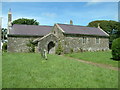
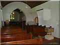
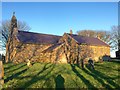
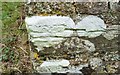
Early Medieval (Dark Age)Site Name: Brawdy ChurchCountry: Wales County: Pembrokeshire Type: Early Christian Sculptured Stone
Nearest Town: St Davids Nearest Village: Brawdy
Map Ref: SM858240 Landranger Map Number: 157
Latitude: 51.873330N Longitude: 5.113053W
Condition:
| 5 | Perfect |
| 4 | Almost Perfect |
| 3 | Reasonable but with some damage |
| 2 | Ruined but still recognisable as an ancient site |
| 1 | Pretty much destroyed, possibly visible as crop marks |
| 0 | No data. |
| -1 | Completely destroyed |
| 5 | Superb |
| 4 | Good |
| 3 | Ordinary |
| 2 | Not Good |
| 1 | Awful |
| 0 | No data. |
| 5 | Can be driven to, probably with disabled access |
| 4 | Short walk on a footpath |
| 3 | Requiring a bit more of a walk |
| 2 | A long walk |
| 1 | In the middle of nowhere, a nightmare to find |
| 0 | No data. |
| 5 | co-ordinates taken by GPS or official recorded co-ordinates |
| 4 | co-ordinates scaled from a detailed map |
| 3 | co-ordinates scaled from a bad map |
| 2 | co-ordinates of the nearest village |
| 1 | co-ordinates of the nearest town |
| 0 | no data |
Internal Links:
External Links:
Early Christian Sculptured stone in Pembrokeshire
Have you visited this site? Please add a comment below.
You may be viewing yesterday's version of this page. To see the most up to date information please register for a free account.
Do not use the above information on other web sites or publications without permission of the contributor.
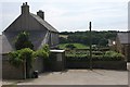
Nearby Images from Geograph Britain and Ireland:
©2007(licence)
©2007(licence)
©2018(licence)
©2019(licence)
©2013(licence)
The above images may not be of the site on this page, they are loaded from Geograph.
Please Submit an Image of this site or go out and take one for us!
Click here to see more info for this site
Nearby sites
Key: Red: member's photo, Blue: 3rd party photo, Yellow: other image, Green: no photo - please go there and take one, Grey: site destroyed
Download sites to:
KML (Google Earth)
GPX (GPS waypoints)
CSV (Garmin/Navman)
CSV (Excel)
To unlock full downloads you need to sign up as a Contributory Member. Otherwise downloads are limited to 50 sites.
Turn off the page maps and other distractions
Nearby sites listing. In the following links * = Image available
2.1km SSW 207° Newgale Submerged Forest Not Known (by us) (SM8475422138)
2.7km N 355° Llandeloy Holy Well* Holy Well or Sacred Spring (SM857267)
2.8km WNW 298° Ffynnon Dewi (Solva) Holy Well or Sacred Spring (SM83352544)
3.2km NE 52° Castle Hill Enclosure Hillfort (SM88422585)
3.4km WSW 249° Dinas Fach* Promontory Fort / Cliff Castle (SM82572290)
3.6km E 84° Rhyndaston-Fawr Tump Round Barrow(s) (SM89422425)
3.8km E 83° Rhyndaston-Fawr* Standing Stone (Menhir) (SM89592433)
3.9km NW 304° Tremaenhir Standing Stones* Standing Stones (SM8268926318)
4.5km E 79° Hayscastle Tump Round Barrow(s) (SM90232463)
4.5km W 268° St Aelbyw's Well (St Elvis) Holy Well or Sacred Spring (SM81242405)
4.6km W 267° St Elvis Farm* Chambered Tomb (SM81202394)
4.7km N 352° Treffynnon* Chambered Tomb (SM85362866)
5.2km NW 308° Llanhowel Church* Early Christian Sculptured Stone (SM818274)
5.4km NW 321° White House (Treglemais)* Chambered Tomb (SM82582839)
5.6km NNE 27° Trehale Stone* Standing Stone (Menhir) (SM88582883)
5.6km W 267° Solva Gribin Fort* Promontory Fort / Cliff Castle (SM80212390)
5.6km WNW 301° Lecha Dolmen Chambered Tomb (SM81152711)
5.6km NE 37° St Edren's Cross* Early Christian Sculptured Stone (SM894283)
5.7km NNE 19° Blaen-Llyn* Standing Stone (Menhir) (SM87882931)
5.7km NNE 22° Trehale House Standing Stone Standing Stone (Menhir) (SM88152920)
5.7km NNE 26° Trehale House Standing Stone (Menhir) (SM88542906)
5.8km NNE 32° Tre-Howell Burial Chamber or Dolmen (SM891288)
5.9km W 271° St Aidan's Church (Solva) Early Christian Sculptured Stone (SM799244)
6.3km ENE 75° Barnards Hill Tumulus Round Barrow(s) (SM91962536)
6.3km NE 37° Clyn Ffwrn Standing Stone (Menhir) (SM89792888)
View more nearby sites and additional images


 We would like to know more about this location. Please feel free to add a brief description and any relevant information in your own language.
 Wir möchten mehr über diese Stätte erfahren. Bitte zögern Sie nicht, eine kurze Beschreibung und relevante Informationen in Deutsch hinzuzufügen.
 Nous aimerions en savoir encore un peu sur les lieux. S'il vous plaît n'hesitez pas à ajouter une courte description et tous les renseignements pertinents dans votre propre langue.
 Quisieramos informarnos un poco más de las lugares. No dude en añadir una breve descripción y otros datos relevantes en su propio idioma.