

<< Our Photo Pages >> Corbalengi Stone - Sculptured Stone in Wales in Ceredigion
Submitted by sgking on Monday, 07 March 2005 Page Views: 14167
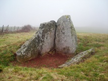
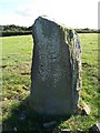
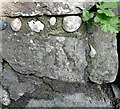
Multi-periodSite Name: Corbalengi Stone Alternative Name: Tresaith Stone, Penbryn StoneCountry: Wales
NOTE: This site is 4.094 km away from the location you searched for.
County: Ceredigion Type: Sculptured Stone
Nearest Town: Cardigan Nearest Village: Tresaith
Map Ref: SN2890151375
Latitude: 52.134112N Longitude: 4.501333W
Condition:
| 5 | Perfect |
| 4 | Almost Perfect |
| 3 | Reasonable but with some damage |
| 2 | Ruined but still recognisable as an ancient site |
| 1 | Pretty much destroyed, possibly visible as crop marks |
| 0 | No data. |
| -1 | Completely destroyed |
| 5 | Superb |
| 4 | Good |
| 3 | Ordinary |
| 2 | Not Good |
| 1 | Awful |
| 0 | No data. |
| 5 | Can be driven to, probably with disabled access |
| 4 | Short walk on a footpath |
| 3 | Requiring a bit more of a walk |
| 2 | A long walk |
| 1 | In the middle of nowhere, a nightmare to find |
| 0 | No data. |
| 5 | co-ordinates taken by GPS or official recorded co-ordinates |
| 4 | co-ordinates scaled from a detailed map |
| 3 | co-ordinates scaled from a bad map |
| 2 | co-ordinates of the nearest village |
| 1 | co-ordinates of the nearest town |
| 0 | no data |
Internal Links:
External Links:
I have visited· I would like to visit
JCBH would like to visit
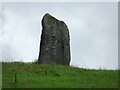
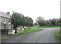
SandyG visited on 15th Sep 2022 - their rating: Cond: 4 Amb: 4 Access: 5 This stone can be seen from the road side in a couple of places.
")
Ordvicies was the name given to a part of North Wales by the romans. An urn full of ashes & Roman coins were excavated from underneath it. They are on display at the Natural History Museum in Cardiff.
Access information from the landowner: There is no right of way to the stone and there are occasionally times when we do have to deny access for farming reasons. However we welcome visitors who ask - and furnish them with lots of information too.
Note that our entry previously stated that the stone is not in its original location, having been moved from a nearby farm. However the landowner has corrected this, saying the stone is in its original location.
You may be viewing yesterday's version of this page. To see the most up to date information please register for a free account.
")
")
")
Do not use the above information on other web sites or publications without permission of the contributor.
Nearby Images from Geograph Britain and Ireland:
©2022(licence)
©2005(licence)
©2024(licence)
©2011(licence)
©2024(licence)
The above images may not be of the site on this page, they are loaded from Geograph.
Please Submit an Image of this site or go out and take one for us!
Click here to see more info for this site
Nearby sites
Key: Red: member's photo, Blue: 3rd party photo, Yellow: other image, Green: no photo - please go there and take one, Grey: site destroyed
Download sites to:
KML (Google Earth)
GPX (GPS waypoints)
CSV (Garmin/Navman)
CSV (Excel)
To unlock full downloads you need to sign up as a Contributory Member. Otherwise downloads are limited to 50 sites.
Turn off the page maps and other distractions
Nearby sites listing. In the following links * = Image available
1.4km SE 134° Castell Nadolig Hillfort (SN29855040)
1.6km NE 48° Gaer Lwyd Hillfort (SN30145240)
2.1km S 171° Caer Pwntan Hillfort (SN29164933)
2.3km NE 39° Garreg Standing Stones Standing Stones (SN304531)
4.4km NE 35° Pendinas Lochtyn* Hillfort (SN31565486)
4.9km NNE 30° Ynys Lochtyn* Ancient Village or Settlement (SN31475552)
6.4km S 184° Pant-Llech-Clawdd Burnt Mound Artificial Mound (SN28264505)
6.6km ENE 75° Castell Crugiau Ancient Village or Settlement (SN35395285)
6.8km ESE 121° Pensarngerrig* Standing Stones (SN346477)
7.4km ESE 104° Caerau Promontory Fort / Cliff Castle (SN36054940)
7.5km NE 47° Gaer Wen Hillfort (SN34635630)
7.8km WSW 246° Llech Yr Ast Standing Stone (Menhir) (SN216485)
8.7km E 97° Crug-Bach Barrow Round Barrow(s) (SN37554995)
8.8km SW 236° Pant y Butler round barrows* Round Barrow(s) (SN21464672)
8.8km ENE 60° Felin Llwyn-Dafydd Promontory Fort / Cliff Castle (SN36685553)
9.2km E 94° Crug Du* Ring Cairn (SN38075039)
9.3km WSW 243° Banc-y-Warren Hillfort (SN20414750)
9.6km W 272° Foel y Mwnt* Promontory Fort / Cliff Castle (SN193520)
9.7km ENE 79° Ffynnon Dewi (Plwmp)* Holy Well or Sacred Spring (SN3854452988)
9.8km NE 45° Castell Bach (Pen y Graig)* Ancient Village or Settlement (SN36045809)
9.9km E 87° Crug Las Round Cairn (SN38805154)
10.0km S 191° Cenarth Churchyard* Standing Stone (Menhir) (SN267416)
10.1km S 189° Cenarth Inscribed Stone Early Christian Sculptured Stone (SN27024149)
10.1km S 190° Ffynnon Llawddog* Holy Well or Sacred Spring (SN268415)
11.0km E 88° Blaengowonfawr Round Barrow(s) (SN39905142)
View more nearby sites and additional images


 We would like to know more about this location. Please feel free to add a brief description and any relevant information in your own language.
 Wir möchten mehr über diese Stätte erfahren. Bitte zögern Sie nicht, eine kurze Beschreibung und relevante Informationen in Deutsch hinzuzufügen.
 Nous aimerions en savoir encore un peu sur les lieux. S'il vous plaît n'hesitez pas à ajouter une courte description et tous les renseignements pertinents dans votre propre langue.
 Quisieramos informarnos un poco más de las lugares. No dude en añadir una breve descripción y otros datos relevantes en su propio idioma.