
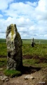

<< Our Photo Pages >> Toros de Guisando - Sculptured Stone in Spain in Castilla y León
Submitted by Armand on Friday, 17 December 2010 Page Views: 8244
Multi-periodSite Name: Toros de GuisandoCountry: Spain
NOTE: This site is 12.11 km away from the location you searched for.
Region: Castilla y León Type: Sculptured Stone
Nearest Town: Ávila Nearest Village: La Atalaya-El Tiembo
Latitude: 40.300579N Longitude: 4.441677W
Condition:
| 5 | Perfect |
| 4 | Almost Perfect |
| 3 | Reasonable but with some damage |
| 2 | Ruined but still recognisable as an ancient site |
| 1 | Pretty much destroyed, possibly visible as crop marks |
| 0 | No data. |
| -1 | Completely destroyed |
| 5 | Superb |
| 4 | Good |
| 3 | Ordinary |
| 2 | Not Good |
| 1 | Awful |
| 0 | No data. |
| 5 | Can be driven to, probably with disabled access |
| 4 | Short walk on a footpath |
| 3 | Requiring a bit more of a walk |
| 2 | A long walk |
| 1 | In the middle of nowhere, a nightmare to find |
| 0 | No data. |
| 5 | co-ordinates taken by GPS or official recorded co-ordinates |
| 4 | co-ordinates scaled from a detailed map |
| 3 | co-ordinates scaled from a bad map |
| 2 | co-ordinates of the nearest village |
| 1 | co-ordinates of the nearest town |
| 0 | no data |
Internal Links:
External Links:
I have visited· I would like to visit
Armand has visited here
")
Various hypotheses have been ventured regarding the meaning of these large sculptures, which can be up to 2.5 meters high, like the one from Villanueva del Campillo, at the head of the valley of Amblés, and which always represent boars or bulls, with marked male sexual organs. According to one of these hypotheses, they can be seen as symbols of wealth in a cattle-raising environment, stones marking winter pasture lands (Álvarez Sanchís 2003), or possibly boundary stones indicating borders between different ethnic territories.
Another interpretation, highlights their religious meaning, suggesting that they may have been intended to protect the cattle and ensure the animals' successful procreation
Also worth considering is the funerary symbolism attached to boars in later contexts. Boars combine a number of meanings, with an essential religious basis, in a highly symbolic signifier: the boar as the protector of cattle, territories and groups of people (perhaps similar to a psychopomp, as is suggested for some of the Iberian zoomorphic sculptures). Very recently, a boar was found engraved in the rock under the base of the northern tower of the gate of San Vicente, in the ramparts of the city walls of Ávila (Álvarez Sanchís 2003). Finally, we cannot discount the hypothesis that such animals might be the zoomorphic manifestation of the deity that performed different functions." Read more at e-Keltoi - Journal of Interdisciplinary Celtic Studies
You may be viewing yesterday's version of this page. To see the most up to date information please register for a free account.
Do not use the above information on other web sites or publications without permission of the contributor.
Nearby Images from Flickr

The above images may not be of the site on this page, but were taken nearby. They are loaded from Flickr so please click on them for image credits.
Click here to see more info for this site
Nearby sites
Click here to view sites on an interactive map of the areaKey: Red: member's photo, Blue: 3rd party photo, Yellow: other image, Green: no photo - please go there and take one, Grey: site destroyed
Download sites to:
KML (Google Earth)
GPX (GPS waypoints)
CSV (Garmin/Navman)
CSV (Excel)
To unlock full downloads you need to sign up as a Contributory Member. Otherwise downloads are limited to 50 sites.
Turn off the page maps and other distractions
Nearby sites listing. In the following links * = Image available
4.5km SSW 206° Las Cogotas. Castro or Chafurdão
6.4km S 182° Piedra Escrita* Standing Stone (Menhir)
21.7km N 9° Necropolis Navaserrada Barrow Cemetery
43.0km ESE 107° Yacimiento Romano de Carranque Ancient Village or Settlement
43.6km NNW 342° Dolmen de Bernuy* Passage Grave
43.7km NNW 342° Prado de las Cruces dolmen* Burial Chamber or Dolmen
45.2km NNW 331° Vettonia Museum* Museum
45.4km NW 304° Ulaca* Castro or Chafurdão
52.2km NNW 335° Castro de Las Cogotas* Castro or Chafurdão
60.7km SE 144° Museo de Santa Cruz* Museum
62.9km ENE 77° Templo de Debod* Ancient Temple
63.3km W 271° Juego de los Bolos* Cairn
63.4km NW 306° Necrópolis Medieval de La Coba Ancient Village or Settlement
63.8km NW 317° Castro de la Mesa de Miranda* Castro or Chafurdão
65.2km ENE 78° Museo Arqueológico Nacional* Museum
73.4km NE 52° Yacimiento Arqueológico de Navalvillar Ancient Village or Settlement
78.9km W 261° El Raso de Candeleda Castro or Chafurdão
83.2km SW 226° Azután dolmen* Burial Chamber or Dolmen
89.9km N 4° Domingo García Rock Art
90.8km WSW 257° Vega del Nino Burial Chamber or Dolmen
90.8km WSW 257° Cruz del Pobre Burial Chamber or Dolmen
91.2km SW 220° La Estrella* Burial Chamber or Dolmen
91.6km ENE 78° Complutum Alcalá de Henares Ancient Village or Settlement
93.7km WSW 258° Cerro del Tejar Burial Chamber or Dolmen
94.2km E 94° Cuevas de Perales de Tajuña* Cave or Rock Shelter
View more nearby sites and additional images


 We would like to know more about this location. Please feel free to add a brief description and any relevant information in your own language.
 Wir möchten mehr über diese Stätte erfahren. Bitte zögern Sie nicht, eine kurze Beschreibung und relevante Informationen in Deutsch hinzuzufügen.
 Nous aimerions en savoir encore un peu sur les lieux. S'il vous plaît n'hesitez pas à ajouter une courte description et tous les renseignements pertinents dans votre propre langue.
 Quisieramos informarnos un poco más de las lugares. No dude en añadir una breve descripción y otros datos relevantes en su propio idioma.