<< Our Photo Pages >> The Well of The Dead - Holy Well or Sacred Spring in Scotland in Highlands
Submitted by TimPrevett on Sunday, 19 August 2007 Page Views: 6468
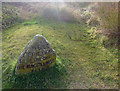
Springs and Holy WellsSite Name: The Well of The DeadCountry: Scotland
NOTE: This site is 0.308 km away from the location you searched for.
County: Highlands Type: Holy Well or Sacred Spring
Nearest Town: Inverness
Map Ref: NH7431844971
Latitude: 57.477513N Longitude: 4.097616W
Condition:
| 5 | Perfect |
| 4 | Almost Perfect |
| 3 | Reasonable but with some damage |
| 2 | Ruined but still recognisable as an ancient site |
| 1 | Pretty much destroyed, possibly visible as crop marks |
| 0 | No data. |
| -1 | Completely destroyed |
| 5 | Superb |
| 4 | Good |
| 3 | Ordinary |
| 2 | Not Good |
| 1 | Awful |
| 0 | No data. |
| 5 | Can be driven to, probably with disabled access |
| 4 | Short walk on a footpath |
| 3 | Requiring a bit more of a walk |
| 2 | A long walk |
| 1 | In the middle of nowhere, a nightmare to find |
| 0 | No data. |
| 5 | co-ordinates taken by GPS or official recorded co-ordinates |
| 4 | co-ordinates scaled from a detailed map |
| 3 | co-ordinates scaled from a bad map |
| 2 | co-ordinates of the nearest village |
| 1 | co-ordinates of the nearest town |
| 0 | no data |
Internal Links:
External Links:
I have visited· I would like to visit
Mikki69 would like to visit
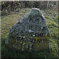
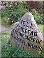
LenGilbert visited on 8th Aug 2014 - their rating: Cond: 4 Amb: 4 Access: 4 Very interesting mystical well that just happened to be located where the battle of Culloden happened. The site of Alexander MacGillivray's, death. He was leading the Clan Chattan into battle against the royalist forces.
")
The Well of the Dead at Culloden Moor battlefield. Possibly has a much older history than the Jacobite Rebellion. Pending research.
You may be viewing yesterday's version of this page. To see the most up to date information please register for a free account.
")
")
")
")
Do not use the above information on other web sites or publications without permission of the contributor.
Nearby Images from Geograph Britain and Ireland:
©2019(licence)
©2008(licence)
©2022(licence)
©2007(licence)
©2012(licence)
The above images may not be of the site on this page, they are loaded from Geograph.
Please Submit an Image of this site or go out and take one for us!
Click here to see more info for this site
Nearby sites
Key: Red: member's photo, Blue: 3rd party photo, Yellow: other image, Green: no photo - please go there and take one, Grey: site destroyed
Download sites to:
KML (Google Earth)
GPX (GPS waypoints)
CSV (Garmin/Navman)
CSV (Excel)
To unlock full downloads you need to sign up as a Contributory Member. Otherwise downloads are limited to 50 sites.
Turn off the page maps and other distractions
Nearby sites listing. In the following links * = Image available
531m S 176° Leanach NE Chambered Cairn (NH74344444)
571m S 180° Leanach Stone Circle (NH743444)
711m ENE 64° Cumberland's Stone* Natural Stone / Erratic / Other Natural Feature (NH74974526)
820m S 187° Culchunaig* Stone Circle (NH74194416)
1.4km SE 135° Milltown Of Clava* Cairn (NH7525043971)
1.4km SE 145° Culdoich* Ring Cairn (NH75114378)
1.5km ESE 110° Balnuaran of Clava Kerb Cairn* Cairn (NH7567444422)
1.5km ESE 112° Balnuaran of Clava SW* Clava Cairn (NH7568944380)
1.5km ESE 109° Balnuaran of Clava Centre* Ring Cairn (NH7572044438)
1.5km ESE 102° Balnuaran of Clava (Stone)* Standing Stone (Menhir) (NH758446)
1.5km ESE 107° Balnuaran Of Clava NE* Clava Cairn (NH7576744478)
1.6km ESE 111° Balnuaran of Clava E* Clava Cairn (NH75804435)
1.8km ESE 101° Mains of Clava SE* Cairn (NH76054457)
2.0km W 278° St Mary's Well (Culloden)* Holy Well or Sacred Spring (NH723453)
2.5km SSE 150° Culdoich S Stone Circle (NH755428)
2.6km SSW 201° Forrest Cottage* Chambered Cairn (NH733426)
3.3km NW 324° Cullearnie* Stone Circle (NH72504768)
3.7km NNW 345° Newton Of Petty Ring Cairn (NH73484858)
3.8km NW 312° Allanfearn* Chambered Cairn (NH716476)
4.1km WNW 296° Milton Stone Row Stone Row / Alignment (NH70704690)
4.2km SSW 201° Daviot Ring Cairn* Stone Circle (NH727411)
4.9km NE 44° Dalcross Mains* Stone Circle (NH779484)
5.2km W 271° Beechwood Farm Site Ancient Mine, Quarry or other Industry (NH6908045190)
5.2km ENE 64° Dalgrambich Farm* Standing Stones (NH79104715)
5.3km W 264° Essich House Class I Pictish Symbol Stone (NH69004456)
View more nearby sites and additional images


 We would like to know more about this location. Please feel free to add a brief description and any relevant information in your own language.
 Wir möchten mehr über diese Stätte erfahren. Bitte zögern Sie nicht, eine kurze Beschreibung und relevante Informationen in Deutsch hinzuzufügen.
 Nous aimerions en savoir encore un peu sur les lieux. S'il vous plaît n'hesitez pas à ajouter une courte description et tous les renseignements pertinents dans votre propre langue.
 Quisieramos informarnos un poco más de las lugares. No dude en añadir una breve descripción y otros datos relevantes en su propio idioma.