

<< Our Photo Pages >> Caves of Nerja - Cave or Rock Shelter in Spain in Andalucía
Submitted by Andy B on Sunday, 12 February 2012 Page Views: 9111
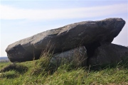
Natural PlacesSite Name: Caves of Nerja Alternative Name: La MinaCountry: Spain
NOTE: This site is 13.007 km away from the location you searched for.
Region: Andalucía Type: Cave or Rock Shelter
Nearest Town: Nerja
Latitude: 36.761667N Longitude: 3.845833W
Condition:
| 5 | Perfect |
| 4 | Almost Perfect |
| 3 | Reasonable but with some damage |
| 2 | Ruined but still recognisable as an ancient site |
| 1 | Pretty much destroyed, possibly visible as crop marks |
| 0 | No data. |
| -1 | Completely destroyed |
| 5 | Superb |
| 4 | Good |
| 3 | Ordinary |
| 2 | Not Good |
| 1 | Awful |
| 0 | No data. |
| 5 | Can be driven to, probably with disabled access |
| 4 | Short walk on a footpath |
| 3 | Requiring a bit more of a walk |
| 2 | A long walk |
| 1 | In the middle of nowhere, a nightmare to find |
| 0 | No data. |
| 5 | co-ordinates taken by GPS or official recorded co-ordinates |
| 4 | co-ordinates scaled from a detailed map |
| 3 | co-ordinates scaled from a bad map |
| 2 | co-ordinates of the nearest village |
| 1 | co-ordinates of the nearest town |
| 0 | no data |
Internal Links:
External Links:
I have visited· I would like to visit
Kuba would like to visit
Andy B has visited here
")
The caves were re-discovered in modern times on 12 January 1959 by five friends, who entered through a narrow sink hole, known as "La Mina". This forms one of the two natural entrances to the cave system. A third entrance was created in 1960 to allow easy access for tourists. The cave is divided into two main parts known as Nerja I and Nerja II. Nerja I includes the Show Galleries which are open to the public, with relatively easy access via a flight of stairs and concreted pathways to allow tourists to move about in the cavern without difficulty. Nerja II, which is not open to the public comprises the Upper Gallery discovered in 1960 and the New Gallery discovered in 1969.
In February 2012 it was announced that cave paintings have been discovered in the Caves or Nerja. Carbon deposits connected with the paintings have been dated to 42,000 years old, which would make them the earliest human paintings ever found. What's more there is no evidence of modern humans in the area at the time, leading to the '' possiblity that the paintings were created by Neanderthals.
More about the caves at Wikipedia and on their official web site.
Note: Dating suggests earliest ever human paintings found - more than 42,000 years old and possibly painted by Neanderthals!
You may be viewing yesterday's version of this page. To see the most up to date information please register for a free account.
")
")
")
")
")
")
")
")
")
")
Do not use the above information on other web sites or publications without permission of the contributor.
Click here to see more info for this site
Nearby sites
Click here to view sites on an interactive map of the areaKey: Red: member's photo, Blue: 3rd party photo, Yellow: other image, Green: no photo - please go there and take one, Grey: site destroyed
Download sites to:
KML (Google Earth)
GPX (GPS waypoints)
CSV (Garmin/Navman)
CSV (Excel)
To unlock full downloads you need to sign up as a Contributory Member. Otherwise downloads are limited to 50 sites.
Turn off the page maps and other distractions
Nearby sites listing. In the following links * = Image available
13.3km ESE 101° Necrópolis Fenicio-Púnica Puente de Noy* Rock Cut Tomb
26.4km N 352° Los Bermejales 7* Burial Chamber or Dolmen
26.5km N 350° Los Bermejales 4* Cist
26.5km N 350° Los Bermejales 5* Cist
28.0km NNW 349° Los Bermejales 1* Burial Chamber or Dolmen
28.3km NW 317° Dólmen de Llano de Zafarraya Burial Chamber or Dolmen
35.9km WNW 290° Necrópolis de la Peña de Hierro Cist
40.8km W 270° Dolmen Cerro de la Corona* Burial Chamber or Dolmen
49.5km NNE 26° Dólmen del Parque de las Ciencias* Modern Stone Circle etc
50.2km WNW 288° Dólmen del Tajillo del Moro* Burial Chamber or Dolmen
50.6km WNW 287° Peñas de Cabrera* Rock Art
51.6km NNE 26° Museo Arqueológico y Etnológico de Granada* Museum
52.7km NNE 27° Abadia del Sacromonte* Cave or Rock Shelter
53.5km WNW 281° Necrópolis de Las Chaperas Burial Chamber or Dolmen
54.2km NNE 13° Zona Arqueológica de Medina Elvira Ancient Village or Settlement
56.1km W 260° Cerro Del Villar* Ancient Village or Settlement
56.5km WNW 291° Aratispi Ancient Village or Settlement
60.4km NNW 330° Necrópolis de Sierra Martilla* Rock Cut Tomb
64.6km N 350° Necrópolis de El Castellón* Barrow Cemetery
64.9km N 351° Peña de los Gitanos* Burial Chamber or Dolmen
65.4km WNW 289° El Tornillo Del Torcal* Natural Stone / Erratic / Other Natural Feature
65.8km WNW 301° Necrópolis de la Angostura* Burial Chamber or Dolmen
66.7km WNW 301° La Peña de los Enamorados* Natural Stone / Erratic / Other Natural Feature
67.1km WNW 301° Piedras Blancas* Rock Cut Tomb
67.6km N 5° Dólmen Pileta de la Zorra Burial Chamber or Dolmen
View more nearby sites and additional images


 We would like to know more about this location. Please feel free to add a brief description and any relevant information in your own language.
 Wir möchten mehr über diese Stätte erfahren. Bitte zögern Sie nicht, eine kurze Beschreibung und relevante Informationen in Deutsch hinzuzufügen.
 Nous aimerions en savoir encore un peu sur les lieux. S'il vous plaît n'hesitez pas à ajouter une courte description et tous les renseignements pertinents dans votre propre langue.
 Quisieramos informarnos un poco más de las lugares. No dude en añadir una breve descripción y otros datos relevantes en su propio idioma.