<< Text Pages >> Bwlch y Ddeufaen N - Standing Stone (Menhir) in Wales in Conwy
Submitted by DavidHoyle on Tuesday, 24 January 2023 Page Views: 545
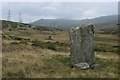
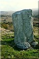
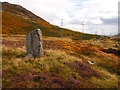
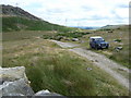
Neolithic and Bronze AgeSite Name: Bwlch y Ddeufaen NCountry: Wales County: Conwy Type: Standing Stone (Menhir)
Nearest Town: Llanfairfechan
Map Ref: SH7145671828
Latitude: 53.227891N Longitude: 3.92707W
Condition:
| 5 | Perfect |
| 4 | Almost Perfect |
| 3 | Reasonable but with some damage |
| 2 | Ruined but still recognisable as an ancient site |
| 1 | Pretty much destroyed, possibly visible as crop marks |
| 0 | No data. |
| -1 | Completely destroyed |
| 5 | Superb |
| 4 | Good |
| 3 | Ordinary |
| 2 | Not Good |
| 1 | Awful |
| 0 | No data. |
| 5 | Can be driven to, probably with disabled access |
| 4 | Short walk on a footpath |
| 3 | Requiring a bit more of a walk |
| 2 | A long walk |
| 1 | In the middle of nowhere, a nightmare to find |
| 0 | No data. |
| 5 | co-ordinates taken by GPS or official recorded co-ordinates |
| 4 | co-ordinates scaled from a detailed map |
| 3 | co-ordinates scaled from a bad map |
| 2 | co-ordinates of the nearest village |
| 1 | co-ordinates of the nearest town |
| 0 | no data |
Be the first person to rate this site - see the 'Contribute!' box in the right hand menu.
Internal Links:
External Links:
Standing Stone (Menhir) in Conwy
Stone from OS Map.
53.227895 -3.927063
You may be viewing yesterday's version of this page. To see the most up to date information please register for a free account.
Do not use the above information on other web sites or publications without permission of the contributor.
Nearby Images from Geograph Britain and Ireland:
©2006(licence)
©2009(licence)
©2015(licence)
©2013(licence)
©2010(licence)
The above images may not be of the site on this page, they are loaded from Geograph.
Please Submit an Image of this site or go out and take one for us!
Click here to see more info for this site
Nearby sites
Key: Red: member's photo, Blue: 3rd party photo, Yellow: other image, Green: no photo - please go there and take one, Grey: site destroyed
Download sites to:
KML (Google Earth)
GPX (GPS waypoints)
CSV (Garmin/Navman)
CSV (Excel)
To unlock full downloads you need to sign up as a Contributory Member. Otherwise downloads are limited to 50 sites.
Turn off the page maps and other distractions
Nearby sites listing. In the following links * = Image available
78m SE 135° Bwlch y Ddeufaen S Standing Stone (Menhir) (SH7151071772)
269m SE 146° Bwlch y Ddeufaen* Standing Stones (SH716716)
269m SE 146° Barclodiad-y-Gawres (Conwy)* Cairn (SH716716)
580m WNW 286° Llanerch Fedw* Cairn (SH709720)
1.1km ESE 115° Cerrig Pryfaid* Stone Circle (SH72467133)
1.4km SSW 210° Carnedd y Ddelw* Clava Cairn (SH707706)
1.8km E 94° Cae Coch* Standing Stone (Menhir) (SH73287166)
2.0km NNE 22° Gwynion Cairns* Barrow Cemetery (SH72257366)
2.0km E 92° Rowen Hut Circles* Ancient Village or Settlement (SH735717)
2.1km WNW 281° Maen Ffordd Rufeinig* Standing Stone (Menhir) (SH694723)
2.1km E 92° Rowen Cross Incised Stone* Early Christian Sculptured Stone (SH736717)
2.3km WNW 282° Ffridd Newydd Arrow stones* Rock Art (SH69237238)
2.3km SSW 194° Carnedd Penyborth Goch Cairn Cairn (SH70846959)
2.3km WSW 247° Afon Anafon Arrow Stone* Sculptured Stone (SH69267098)
2.4km W 277° Carn yr Llechwedd* Cairn (SH691722)
2.4km WNW 301° Garreg Fawr* Carving (SH6939373132)
2.4km NW 322° Dinas Settlement* Ancient Village or Settlement (SH700738)
2.5km E 92° Ffon-y-Cawr* Standing Stone (Menhir) (SH73917166)
2.6km N 4° Moelfre cairn* Cairn (SH71727441)
2.6km E 90° Maen y bardd* Burial Chamber or Dolmen (SH74067178)
2.7km E 87° Caerhun Chambered Tomb* Chambered Tomb (SH74127189)
2.7km NNE 24° Cerrig Gwynion (Conwy)* Cist (SH72627423)
2.7km E 89° Caerhun Stones* Standing Stones (SH74177182)
2.8km NNE 13° Cefn Coch (Penmaenmawr)* Ring Cairn (SH72167457)
2.8km E 82° Pen y ffridd Farm Hut Circles* Ancient Village or Settlement (SH74297214)
View more nearby sites and additional images


 We would like to know more about this location. Please feel free to add a brief description and any relevant information in your own language.
 Wir möchten mehr über diese Stätte erfahren. Bitte zögern Sie nicht, eine kurze Beschreibung und relevante Informationen in Deutsch hinzuzufügen.
 Nous aimerions en savoir encore un peu sur les lieux. S'il vous plaît n'hesitez pas à ajouter une courte description et tous les renseignements pertinents dans votre propre langue.
 Quisieramos informarnos un poco más de las lugares. No dude en añadir una breve descripción y otros datos relevantes en su propio idioma.