


<< Our Photo Pages >> Clogwyn-yr-Eryr - Stone Row / Alignment in Wales in Conwy
Submitted by Postman on Tuesday, 02 October 2012 Page Views: 3657
Neolithic and Bronze AgeSite Name: Clogwyn-yr-EryrCountry: Wales County: Conwy Type: Stone Row / Alignment
Nearest Town: Dolgarrog
Map Ref: SH72506687
Latitude: 53.183601N Longitude: 3.909458W
Condition:
| 5 | Perfect |
| 4 | Almost Perfect |
| 3 | Reasonable but with some damage |
| 2 | Ruined but still recognisable as an ancient site |
| 1 | Pretty much destroyed, possibly visible as crop marks |
| 0 | No data. |
| -1 | Completely destroyed |
| 5 | Superb |
| 4 | Good |
| 3 | Ordinary |
| 2 | Not Good |
| 1 | Awful |
| 0 | No data. |
| 5 | Can be driven to, probably with disabled access |
| 4 | Short walk on a footpath |
| 3 | Requiring a bit more of a walk |
| 2 | A long walk |
| 1 | In the middle of nowhere, a nightmare to find |
| 0 | No data. |
| 5 | co-ordinates taken by GPS or official recorded co-ordinates |
| 4 | co-ordinates scaled from a detailed map |
| 3 | co-ordinates scaled from a bad map |
| 2 | co-ordinates of the nearest village |
| 1 | co-ordinates of the nearest town |
| 0 | no data |
Internal Links:
External Links:
")
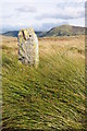
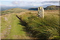
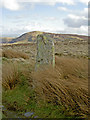
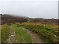
Coflein has this site down as a possible stone row, I am inclined to agree.
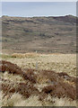
There are four stones, stone one is in the north west about two foot tall, across the grassy path is stone two, an impressive six footer, with holes drilled in two sides. Stone three is in the south east and has fallen, it's six feet long, and has a drill hole in its upper surface. Stone four is fifty yards up hill, out of line with the other three, and also holed, leading us through a cleft in the hill tops towards Pen Llithrig y wrach. Views north to Pen y Gaer and the Conway valley is extremely pleasant.
You may be viewing yesterday's version of this page. To see the most up to date information please register for a free account.
")
")
")
")
Do not use the above information on other web sites or publications without permission of the contributor.
Nearby Images from Geograph Britain and Ireland:
©2012(licence)
©2012(licence)
©2008(licence)
©2008(licence)
©2023(licence)
The above images may not be of the site on this page, they are loaded from Geograph.
Please Submit an Image of this site or go out and take one for us!
Click here to see more info for this site
Nearby sites
Key: Red: member's photo, Blue: 3rd party photo, Yellow: other image, Green: no photo - please go there and take one, Grey: site destroyed
Download sites to:
KML (Google Earth)
GPX (GPS waypoints)
CSV (Garmin/Navman)
CSV (Excel)
To unlock full downloads you need to sign up as a Contributory Member. Otherwise downloads are limited to 50 sites.
Turn off the page maps and other distractions
Nearby sites listing. In the following links * = Image available
1.0km NE 56° Hafodygors Wen* Ring Cairn (SH73366742)
1.4km WNW 301° Afon Garreg Wen* Standing Stone (Menhir) (SH71336761)
1.4km NNE 17° Ffrith-Y-Bont Stone Row* Stone Row / Alignment (SH72946819)
1.8km WSW 257° Pant y Griafolen* Ancient Village or Settlement (SH707665)
2.0km ENE 74° Waen Bryn-Gwenith* Burial Chamber or Dolmen (SH74476738)
2.8km ESE 103° Cae Du* Cairn (SH75206616)
3.2km NNW 327° Carnedd Penyborth Goch Cairn Cairn (SH70846959)
3.5km NE 44° Pen-y-Gaer (Conwy)* Hillfort (SH750693)
3.7km WSW 253° Foel Grach* Cairn (SH68886589)
4.1km NNW 333° Carnedd y Ddelw* Clava Cairn (SH707706)
4.5km N 358° Cerrig Pryfaid* Stone Circle (SH72467133)
4.6km ENE 77° Porth Llwyd Burial Chamber or Dolmen (SH77036777)
4.6km S 190° Pen Llithrig Y Wrach* Cairn (SH71606232)
4.8km NNW 348° Barclodiad-y-Gawres (Conwy)* Cairn (SH716716)
4.8km NNW 348° Bwlch y Ddeufaen* Standing Stones (SH716716)
4.8km N 8° Cae Coch* Standing Stone (Menhir) (SH73287166)
4.9km WSW 238° Carnedd Llewelyn* Cairn (SH683644)
4.9km N 10° Rowen Hut Circles* Ancient Village or Settlement (SH735717)
4.9km NNE 11° Rowen Cross Incised Stone* Early Christian Sculptured Stone (SH736717)
5.0km NNE 15° Ffon-y-Cawr* Standing Stone (Menhir) (SH73917166)
5.0km NNW 347° Bwlch y Ddeufaen S Standing Stone (Menhir) (SH7151071772)
5.1km NNW 347° Bwlch y Ddeufaen N Standing Stone (Menhir) (SH7145671828)
5.1km NNE 16° Maen y bardd* Burial Chamber or Dolmen (SH74067178)
5.2km NNE 17° Caerhun Stones* Standing Stones (SH74177182)
5.2km NW 320° Afon Anafon Arrow Stone* Sculptured Stone (SH69267098)
View more nearby sites and additional images


 We would like to know more about this location. Please feel free to add a brief description and any relevant information in your own language.
 Wir möchten mehr über diese Stätte erfahren. Bitte zögern Sie nicht, eine kurze Beschreibung und relevante Informationen in Deutsch hinzuzufügen.
 Nous aimerions en savoir encore un peu sur les lieux. S'il vous plaît n'hesitez pas à ajouter une courte description et tous les renseignements pertinents dans votre propre langue.
 Quisieramos informarnos un poco más de las lugares. No dude en añadir una breve descripción y otros datos relevantes en su propio idioma.