


<< Our Photo Pages >> Siambr Gladdu Caer Bach - Chambered Tomb in Wales in Conwy
Submitted by SteCymru14 on Tuesday, 13 August 2019 Page Views: 1711
Neolithic and Bronze AgeSite Name: Siambr Gladdu Caer Bach Alternative Name: Cromlech Caer BachCountry: Wales County: Conwy Type: Chambered Tomb
Nearest Village: Rowen
Map Ref: SH7436572834
Latitude: 53.237626N Longitude: 3.883915W
Condition:
| 5 | Perfect |
| 4 | Almost Perfect |
| 3 | Reasonable but with some damage |
| 2 | Ruined but still recognisable as an ancient site |
| 1 | Pretty much destroyed, possibly visible as crop marks |
| 0 | No data. |
| -1 | Completely destroyed |
| 5 | Superb |
| 4 | Good |
| 3 | Ordinary |
| 2 | Not Good |
| 1 | Awful |
| 0 | No data. |
| 5 | Can be driven to, probably with disabled access |
| 4 | Short walk on a footpath |
| 3 | Requiring a bit more of a walk |
| 2 | A long walk |
| 1 | In the middle of nowhere, a nightmare to find |
| 0 | No data. |
| 5 | co-ordinates taken by GPS or official recorded co-ordinates |
| 4 | co-ordinates scaled from a detailed map |
| 3 | co-ordinates scaled from a bad map |
| 2 | co-ordinates of the nearest village |
| 1 | co-ordinates of the nearest town |
| 0 | no data |
Internal Links:
External Links:
I have visited· I would like to visit
elad13 Paolos2202 would like to visit
")
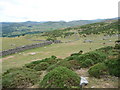
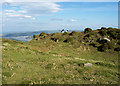
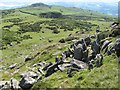
Walking past Caer Bach hillfort and hut circle and found what appears to be a chambered tomb. It displays a huge capstone atop three stones leaving a small central area around the same size as the chamber of the nearby Maen-y-bardd. This site appears to have much of the earthen mound still encompassing it.
I welcome the views of others on this - amazed to not find the site marked on Coflein or on this site.
Siambr Gladdu Caer Bach ar droed y bryngaer wrth ymyl yr hen gytiau. Hapus cael fy nghywiro am y safle gan nad yw’n ymddangos ar unrhyw fapiau, hyd y gwn i.
You may be viewing yesterday's version of this page. To see the most up to date information please register for a free account.
")
Do not use the above information on other web sites or publications without permission of the contributor.
Nearby Images from Geograph Britain and Ireland:
©2010(licence)
©2006(licence)
©2014(licence)
©2020(licence)
©2009(licence)
The above images may not be of the site on this page, they are loaded from Geograph.
Please Submit an Image of this site or go out and take one for us!
Click here to see more info for this site
Nearby sites
Key: Red: member's photo, Blue: 3rd party photo, Yellow: other image, Green: no photo - please go there and take one, Grey: site destroyed
Download sites to:
KML (Google Earth)
GPX (GPS waypoints)
CSV (Garmin/Navman)
CSV (Excel)
To unlock full downloads you need to sign up as a Contributory Member. Otherwise downloads are limited to 50 sites.
Turn off the page maps and other distractions
Nearby sites listing. In the following links * = Image available
96m N 356° Caer Bach Hut Circle* Ancient Village or Settlement (SH74367293)
170m N 10° Caer Bach* Hillfort (SH744730)
243m SSW 194° Ddwyffrwd Cairns* Barrow Cemetery (SH743726)
306m N 358° Caer Bach Cairn* Cairn (SH74367314)
432m S 190° Rhiw Hut Circle Ancient Village or Settlement (SH74287241)
535m S 182° Ffrith y Ddwyffrwd* Cairn (SH74337230)
698m S 185° Pen y ffridd Farm Hut Circles* Ancient Village or Settlement (SH74297214)
869m NNW 326° Maen Penddu* Standing Stone (Menhir) (SH73907357)
919m NW 324° Cefn Maen Amor* Stone Circle (SH73847359)
975m SSW 193° Caerhun Chambered Tomb* Chambered Tomb (SH74127189)
1.0km S 189° Caerhun Stones* Standing Stones (SH74177182)
1.1km S 174° Caerhun Stone E Standing Stone (Menhir) (SH7444571763)
1.1km SSW 195° Maen y bardd* Burial Chamber or Dolmen (SH74067178)
1.1km NE 40° Ffynnon Gelynin Hut Circle Ancient Village or Settlement (SH75117366)
1.1km NE 40° St Celynin's Well* Holy Well or Sacred Spring (SH75127369)
1.3km SSW 200° Ffon-y-Cawr* Standing Stone (Menhir) (SH73917166)
1.4km SSW 212° Rowen Cross Incised Stone* Early Christian Sculptured Stone (SH736717)
1.4km SW 216° Rowen Hut Circles* Ancient Village or Settlement (SH735717)
1.5km NE 42° Cerrig-Y-Ddinas* Hillfort (SH75427395)
1.6km SW 221° Cae Coch* Standing Stone (Menhir) (SH73287166)
1.6km NE 35° Southern Hut Group Ancient Village or Settlement (SH75347413)
1.7km NE 34° Northern Hut Group* Ancient Village or Settlement (SH75337418)
2.1km N 356° Waen Gyrach* Ring Cairn (SH74277493)
2.2km N 10° Maen Hir (Conwy)* Standing Stone (Menhir) (SH74787496)
2.2km NW 307° Cerrig Gwynion (Conwy)* Cist (SH72627423)
View more nearby sites and additional images


 We would like to know more about this location. Please feel free to add a brief description and any relevant information in your own language.
 Wir möchten mehr über diese Stätte erfahren. Bitte zögern Sie nicht, eine kurze Beschreibung und relevante Informationen in Deutsch hinzuzufügen.
 Nous aimerions en savoir encore un peu sur les lieux. S'il vous plaît n'hesitez pas à ajouter une courte description et tous les renseignements pertinents dans votre propre langue.
 Quisieramos informarnos un poco más de las lugares. No dude en añadir una breve descripción y otros datos relevantes en su propio idioma.