<< Our Photo Pages >> Moel Oernant Ring Cairn - Ring Cairn in Wales in Gwynedd
Submitted by TAlanJones on Tuesday, 03 May 2022 Page Views: 428
Neolithic and Bronze AgeSite Name: Moel Oernant Ring CairnCountry: Wales
NOTE: This site is 0.53 km away from the location you searched for.
County: Gwynedd Type: Ring Cairn
Nearest Town: Trawsfynydd Nearest Village: Bronaber
Map Ref: SH7389033660
Latitude: 52.885566N Longitude: 3.875671W
Condition:
| 5 | Perfect |
| 4 | Almost Perfect |
| 3 | Reasonable but with some damage |
| 2 | Ruined but still recognisable as an ancient site |
| 1 | Pretty much destroyed, possibly visible as crop marks |
| 0 | No data. |
| -1 | Completely destroyed |
| 5 | Superb |
| 4 | Good |
| 3 | Ordinary |
| 2 | Not Good |
| 1 | Awful |
| 0 | No data. |
| 5 | Can be driven to, probably with disabled access |
| 4 | Short walk on a footpath |
| 3 | Requiring a bit more of a walk |
| 2 | A long walk |
| 1 | In the middle of nowhere, a nightmare to find |
| 0 | No data. |
| 5 | co-ordinates taken by GPS or official recorded co-ordinates |
| 4 | co-ordinates scaled from a detailed map |
| 3 | co-ordinates scaled from a bad map |
| 2 | co-ordinates of the nearest village |
| 1 | co-ordinates of the nearest town |
| 0 | no data |
Internal Links:
External Links:
")
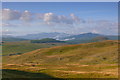
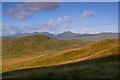
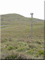
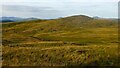
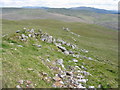
Situated within the bwlch or col between Craiglaseithin and Moel Oernant the site is described by Coflein as being the location of a ring cairn consisting of a 9m diameter low stone bank? Having visited the site I'm not that convinced but then again I haven't been privy to any existing archaeological survey or recorded information concerning the site beyond that of the Coflein entry. However, I am aware that there are ancient settlement sites in close proximity, and that there's a cairn a few metres to the NW so the site may well contain a ring cairn?
My photographs and descriptions are therefore the observations I made during my recent visit.
You may be viewing yesterday's version of this page. To see the most up to date information please register for a free account.
")
")
Do not use the above information on other web sites or publications without permission of the contributor.
Nearby Images from Geograph Britain and Ireland:
©2014(licence)
©2014(licence)
©2007(licence)
©2022(licence)
©2007(licence)
The above images may not be of the site on this page, they are loaded from Geograph.
Please Submit an Image of this site or go out and take one for us!
Click here to see more info for this site
Nearby sites
Key: Red: member's photo, Blue: 3rd party photo, Yellow: other image, Green: no photo - please go there and take one, Grey: site destroyed
Download sites to:
KML (Google Earth)
GPX (GPS waypoints)
CSV (Garmin/Navman)
CSV (Excel)
To unlock full downloads you need to sign up as a Contributory Member. Otherwise downloads are limited to 50 sites.
Turn off the page maps and other distractions
Nearby sites listing. In the following links * = Image available
92m WNW 298° Hut Circle West of Moel Oernant* Ancient Village or Settlement (SH7381033705)
107m WNW 290° Moel Oernant Cairn* Cairn (SH7379033700)
200m S 181° Stone East of Craiglaseithin* Natural Stone / Erratic / Other Natural Feature (SH7388233460)
223m WNW 295° Hut Circle Settlement west of Moel Oernant* Ancient Village or Settlement (SH7369033760)
451m S 186° Two Cairns east of Craiglaseithin* Barrow Cemetery (SH7383333212)
454m S 186° Kerb Cairn east of Craiglaseithin* Cairn (SH7383033210)
650m SSW 193° Cairn and Cist west of Llyn Gelli Gain* Cairn (SH7373033030)
666m W 277° Hut Circle Settlement north west of Craiglaseithin* Ancient Village or Settlement (SH7323033760)
887m SW 229° Cairn and cist close to Nant Bryn Llaeth* Cairn (SH732331)
927m WSW 252° Stones West of Craiglaseithin* Natural Stone / Erratic / Other Natural Feature (SH7300033390)
959m SW 217° Three Small Cairns of Llyn Gelli Gain* Cairn (SH7329032910)
981m SW 222° Llyn Gelli Gain Ring Cairn* Ring Cairn (SH7321032950)
995m SW 217° Llyn Gelli Gain Cairn* Cairn (SH7327032880)
1.0km NW 308° Fridd Bodyfyddau enclosed settlement* Ancient Village or Settlement (SH731343)
1.3km WSW 259° Ffridd Glap Kerb Cairn* Cairn (SH7264233441)
1.3km W 260° Ffridd Glap Cairn Field* Barrow Cemetery (SH7256033450)
1.5km S 188° Hut Circle Settlement East of Pig Idris* Ancient Village or Settlement (SH7365032210)
1.5km WSW 248° Cairn South of Nant Bryn Llefrith* Cairn (SH7251033140)
1.7km S 190° Cairn North of Afon Gain* Cairn (SH7356031970)
2.1km SSW 213° Penystryd Roman Kilns* Ancient Mine, Quarry or other Industry (SH727319)
2.4km SSW 193° Bedd Porus* Early Christian Sculptured Stone (SH73293136)
2.7km SSW 195° llech Idris* Standing Stone (Menhir) (SH73113108)
2.8km SSW 208° Pen-Y-Stryd* Stone Circle (SH725312)
3.2km WSW 257° Maen Llwyd (Bronaber)* Standing Stone (Menhir) (SH707330)
3.7km WSW 250° Eden Standing Stone* Standing Stone (Menhir) (SH70373250)
View more nearby sites and additional images


 We would like to know more about this location. Please feel free to add a brief description and any relevant information in your own language.
 Wir möchten mehr über diese Stätte erfahren. Bitte zögern Sie nicht, eine kurze Beschreibung und relevante Informationen in Deutsch hinzuzufügen.
 Nous aimerions en savoir encore un peu sur les lieux. S'il vous plaît n'hesitez pas à ajouter une courte description et tous les renseignements pertinents dans votre propre langue.
 Quisieramos informarnos un poco más de las lugares. No dude en añadir una breve descripción y otros datos relevantes en su propio idioma.