


<< Our Photo Pages >> The Maiden Stone (Tullibody) - Sculptured Stone in Scotland in Clackmannanshire
Submitted by Anne T on Monday, 12 November 2018 Page Views: 2818
Multi-periodSite Name: The Maiden Stone (Tullibody)Country: Scotland County: Clackmannanshire Type: Sculptured Stone
Nearest Town: Alloa / Sterling Nearest Village: Tullibody
Map Ref: NS86039533
Latitude: 56.137025N Longitude: 3.835529W
Condition:
| 5 | Perfect |
| 4 | Almost Perfect |
| 3 | Reasonable but with some damage |
| 2 | Ruined but still recognisable as an ancient site |
| 1 | Pretty much destroyed, possibly visible as crop marks |
| 0 | No data. |
| -1 | Completely destroyed |
| 5 | Superb |
| 4 | Good |
| 3 | Ordinary |
| 2 | Not Good |
| 1 | Awful |
| 0 | No data. |
| 5 | Can be driven to, probably with disabled access |
| 4 | Short walk on a footpath |
| 3 | Requiring a bit more of a walk |
| 2 | A long walk |
| 1 | In the middle of nowhere, a nightmare to find |
| 0 | No data. |
| 5 | co-ordinates taken by GPS or official recorded co-ordinates |
| 4 | co-ordinates scaled from a detailed map |
| 3 | co-ordinates scaled from a bad map |
| 2 | co-ordinates of the nearest village |
| 1 | co-ordinates of the nearest town |
| 0 | no data |
Internal Links:
External Links:
I have visited· I would like to visit
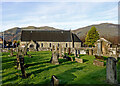
Anne T visited on 31st Oct 2018 - their rating: Cond: 3 Amb: 3 Access: 4 The Maiden Stone, Tullibody: This stone coffin is next to the ruins of the old church. We parked in the car park for the new church and walked through the graveyard which runs parallel to the road. Some really unusual tombstones, and quite spooky to walk through the graveyard and look around the outside of the Old Church as dusk was falling on Halloween!
 (PID:188378)")
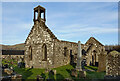
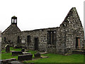
This long cist or stone coffin is marked on the OS map and is located 4 metres north of the north wall of Tullibody Old Church. This is an unusual coffin, as it is a 2.2m long open coffin with a niche for the head and arms, with a large, triangular stone placed on top of it. I had previously understood the triangular stone might have been part of a standing stone which had been repurposed, but Canmore refers to the stone as a 'coped cover' - see Canmore ID 47062 for more information.
The Maiden Stone is reputed to be the coffin of a lady called Martha Wishart, who died circa 1449 (see the comment below for folklore relating to Martha) and looks as if the stone has been placed 'as if to stop the occupant rising from the grave'. This felt particularly spooky as we visited the site in the early evening of Halloween as it was starting to get dark!
The old church was founded in 1149, but various sources say it is believed there were earlier churches on the site, Wikipedia saying: "It is thought that the church in Tullibody dates from the end of the fourth century and St. Serf ministered to the church in the 5th century on his journeys to Alva." I am trying to track down the original sources and will post the links/information when (if!) I find them.
You may be viewing yesterday's version of this page. To see the most up to date information please register for a free account.
 (PID:188380)")
 (PID:188379)")
 (PID:188377)")
Do not use the above information on other web sites or publications without permission of the contributor.
Nearby Images from Geograph Britain and Ireland:
©2023(licence)
©2023(licence)

©2017(licence)
©2017(licence)
©2011(licence)
The above images may not be of the site on this page, they are loaded from Geograph.
Please Submit an Image of this site or go out and take one for us!
Click here to see more info for this site
Nearby sites
Key: Red: member's photo, Blue: 3rd party photo, Yellow: other image, Green: no photo - please go there and take one, Grey: site destroyed
Download sites to:
KML (Google Earth)
GPX (GPS waypoints)
CSV (Garmin/Navman)
CSV (Excel)
To unlock full downloads you need to sign up as a Contributory Member. Otherwise downloads are limited to 50 sites.
Turn off the page maps and other distractions
Nearby sites listing. In the following links * = Image available
39m E 97° Priest's Well (Tullibody) Holy Well or Sacred Spring (NS8606995324)
426m WNW 289° Lady's Well (Tullibody) Holy Well or Sacred Spring (NS85639548)
692m SSW 212° Haer Stane* Standing Stone (Menhir) (NS85659475)
3.3km NE 46° Dwarf's Tomb (Alva) Burial Chamber or Dolmen (NS88489754)
3.4km NE 54° St Serf's Well (Alva) Holy Well or Sacred Spring (NS88819723)
3.6km NE 43° Ladies Well (Alva) Holy Well or Sacred Spring (NS88579788)
4.0km SE 128° Hawk Hill Cairn (Alloa) Cairn (NS89119282)
4.8km WNW 283° Airthrey Stone* Standing Stone (Menhir) (NS81409650)
4.8km WNW 288° Logie Old Kirk (Stirling)* Early Christian Sculptured Stone (NS81549696)
4.8km WNW 284° The Victoria Stone* Marker Stone (NS8141296608)
4.9km ESE 122° Parkmill Cross (Alloa) Ancient Cross (NS9013392661)
5.1km W 272° Abbey Craig Vitrified Fort* Hillfort (NS80949565)
5.3km N 5° Bengengie North Ancient Village or Settlement (NN8668000601)
5.3km ESE 119° Hawk Hill (Alloa) Stone Circle (NS906926)
5.4km WNW 299° Fairy Well (Logie)* Holy Well or Sacred Spring (NS81359804)
5.5km ENE 65° Lady's Well (Tillicoultry) Holy Well or Sacred Spring (NS91119749)
5.5km W 273° Bel Stane (Causewayhead) Standing Stone (Menhir) (NS805958)
5.6km WNW 284° Pathfoot Stone* Standing Stone (Menhir) (NS8060496871)
6.1km ESE 123° Mercat Cross (Clackmannan)* Ancient Cross (NS9111091889)
6.1km ESE 123° Stone of Mannan* Standing Stone (Menhir) (NS91119188)
6.1km NW 308° Pendreich 3 (Bridge of Allan) Cairn (NS81259922)
6.2km NW 308° Pendreich 1 (Bridge of Allan) Cairn (NS8124499236)
6.3km SE 124° Lady Well (Clackmannan) Holy Well or Sacred Spring (NS91129166)
6.3km NW 309° Pendreich 2 (Bridge of Allan) Cairn (NS81239938)
6.3km WNW 286° Lentran (Bridge of Allan) Cist (NS80039720)
View more nearby sites and additional images


 We would like to know more about this location. Please feel free to add a brief description and any relevant information in your own language.
 Wir möchten mehr über diese Stätte erfahren. Bitte zögern Sie nicht, eine kurze Beschreibung und relevante Informationen in Deutsch hinzuzufügen.
 Nous aimerions en savoir encore un peu sur les lieux. S'il vous plaît n'hesitez pas à ajouter une courte description et tous les renseignements pertinents dans votre propre langue.
 Quisieramos informarnos un poco más de las lugares. No dude en añadir una breve descripción y otros datos relevantes en su propio idioma.