<< Text Pages >> Ffynnon Gower (Llangower) - Holy Well or Sacred Spring in Wales in Gwynedd
Submitted by Sunny100 on Friday, 31 December 2010 Page Views: 7917
Springs and Holy WellsSite Name: Ffynnon Gower (Llangower) Alternative Name: St Cywair's Holy Well, St Gwyr's WellCountry: Wales County: Gwynedd Type: Holy Well or Sacred Spring
Nearest Town: Dolgellau Nearest Village: Llangower
Map Ref: SH900315
Latitude: 52.869696N Longitude: 3.635631W
Condition:
| 5 | Perfect |
| 4 | Almost Perfect |
| 3 | Reasonable but with some damage |
| 2 | Ruined but still recognisable as an ancient site |
| 1 | Pretty much destroyed, possibly visible as crop marks |
| 0 | No data. |
| -1 | Completely destroyed |
| 5 | Superb |
| 4 | Good |
| 3 | Ordinary |
| 2 | Not Good |
| 1 | Awful |
| 0 | No data. |
| 5 | Can be driven to, probably with disabled access |
| 4 | Short walk on a footpath |
| 3 | Requiring a bit more of a walk |
| 2 | A long walk |
| 1 | In the middle of nowhere, a nightmare to find |
| 0 | No data. |
| 5 | co-ordinates taken by GPS or official recorded co-ordinates |
| 4 | co-ordinates scaled from a detailed map |
| 3 | co-ordinates scaled from a bad map |
| 2 | co-ordinates of the nearest village |
| 1 | co-ordinates of the nearest town |
| 0 | no data |
Internal Links:
External Links:
Holy Well or Sacred Spring in Gwynedd
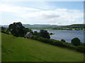
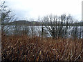
Ffynnon Gower holy well/spring is located about half a mile south of the hamlet of Llangower, and just a little south of Bryn-hynod House. The Flag Station House halt of the Bala Lake Railway is close by. There are splendid views from here across the lake with the mountains of Snowdonia beyond.
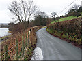
According to legend, the well had magical healing properties. The water was regarded as a cure all. It is not too difficult to find, being located between a pathway and a row of trees. And, although there is not much to see today, the large rectangular hollow in which the spring issues is quite prominent. The ancient spring is, however, often dried-up. The well is named after St Cywair who dwelt here in the 5th or 6th century CE.
St Cywair or Gwyr, a 5th century Irish princess married king Coel Godhibog of the north Britains. She was the mother of Llywarch Hen, the early Welsh bard, and St Pabo. The little church at Llangower is dedicated to her memory, and her feast day is still celebrated here on 11th July.
Legend also says that there was another well in this area, but that it now lies under the waters of Lake Bala (Llyn Tegid). Apparently the well keeper forgot to put the cover over the well. This caused the spirit who lived in the well to become angry and the water gushed out forming the lake itself. The following morning when the local people looked out they saw a 3 mile length of water - today the lake is 5 miles long. There are reports that when the lake is clear buildings from the old village can be seen beneath.
You may be viewing yesterday's version of this page. To see the most up to date information please register for a free account.
Do not use the above information on other web sites or publications without permission of the contributor.
Nearby Images from Geograph Britain and Ireland:
©2011(licence)
©2016(licence)
©2016(licence)
©2016(licence)
©2016(licence)
The above images may not be of the site on this page, they are loaded from Geograph.
Please Submit an Image of this site or go out and take one for us!
Click here to see more info for this site
Nearby sites
Key: Red: member's photo, Blue: 3rd party photo, Yellow: other image, Green: no photo - please go there and take one, Grey: site destroyed
Download sites to:
KML (Google Earth)
GPX (GPS waypoints)
CSV (Garmin/Navman)
CSV (Excel)
To unlock full downloads you need to sign up as a Contributory Member. Otherwise downloads are limited to 50 sites.
Turn off the page maps and other distractions
Nearby sites listing. In the following links * = Image available
2.6km SSW 192° Boncyn Crwn* Cairn (SH894290)
2.6km S 187° Boncyn Pennant Groes* Artificial Mound (SH896289)
4.0km N 353° Moel Y Garnedd* Cairn (SH896355)
4.8km NNE 25° Ffynnon Beuno (Bala)* Holy Well or Sacred Spring (SH92163584)
5.4km NNE 32° Bala Modern Eisteddfod Stone Circle* Modern Stone Circle etc (SH9293836035)
6.1km WNW 297° Cairn East of Moel Ymenyn* Cairn (SH846344)
6.5km NE 37° Pabell Llywarch Hen* Stone Circle (SH940366)
6.7km WNW 296° Moel Ymenyn Cairn* Cairn (SH840346)
6.8km SW 231° Afon Dyfrdwy (River Dee) Cairn* Cairn (SH846274)
6.8km SW 233° Afon Dyfrdwy (River Dee) Settlement* Ancient Village or Settlement (SH845275)
7.2km ENE 75° Carnedd Wen (Llangywer) Cairn (SH97033315)
8.0km SW 223° Pant Clyd Round Cairn* Round Cairn (SH8440225764)
8.2km W 280° Cairn SE of Bryn Cau* Cairn (SH8195233050)
8.4km W 278° Bancian Duon Hut Circle Settlement* Ancient Village or Settlement (SH81653283)
8.5km NNW 328° Ffridd Felen* Cairn (SH856388)
8.6km NNW 329° Llidiardau* Standing Stone (Menhir) (SH857390)
9.1km NW 306° Moel yr Eglwys* Cairn (SH82703695)
9.3km NNW 344° Hafod Fadog Memorial* Modern Stone Circle etc (SH87594049)
9.6km NE 52° Ffynnon Derfel* Holy Well or Sacred Spring (SH97773723)
10.4km NNW 341° Pen Garneddwen Cairn* Cairn (SH868414)
10.6km ENE 68° Carnedd Wen (Llandderfel) Cairn (SJ000352)
10.8km NE 37° Coed y Bedo* Standing Stone (Menhir) (SH96664003)
10.8km SW 222° Dolddeuli* Standing Stone (Menhir) (SH826236)
11.7km NNW 327° Clogwyn Du Cairn* Cairn (SH8388141462)
11.8km NW 325° Bryn Du Cairn* Cairn (SH8346841315)
View more nearby sites and additional images


 We would like to know more about this location. Please feel free to add a brief description and any relevant information in your own language.
 Wir möchten mehr über diese Stätte erfahren. Bitte zögern Sie nicht, eine kurze Beschreibung und relevante Informationen in Deutsch hinzuzufügen.
 Nous aimerions en savoir encore un peu sur les lieux. S'il vous plaît n'hesitez pas à ajouter une courte description et tous les renseignements pertinents dans votre propre langue.
 Quisieramos informarnos un poco más de las lugares. No dude en añadir una breve descripción y otros datos relevantes en su propio idioma.