<< Image Pages >> St Canna's Church (Llangan) - Ancient Cross in Wales in West Glamorgan
Submitted by Sunny100 on Sunday, 08 August 2010 Page Views: 8761
Early Medieval (Dark Age)Site Name: St Canna's Church (Llangan) Alternative Name: St Canna's Cross,Country: Wales County: West Glamorgan Type: Ancient Cross
Nearest Town: Cowbridge Nearest Village: Llangan
Map Ref: SS957778
Latitude: 51.489496N Longitude: 3.503647W
Condition:
| 5 | Perfect |
| 4 | Almost Perfect |
| 3 | Reasonable but with some damage |
| 2 | Ruined but still recognisable as an ancient site |
| 1 | Pretty much destroyed, possibly visible as crop marks |
| 0 | No data. |
| -1 | Completely destroyed |
| 5 | Superb |
| 4 | Good |
| 3 | Ordinary |
| 2 | Not Good |
| 1 | Awful |
| 0 | No data. |
| 5 | Can be driven to, probably with disabled access |
| 4 | Short walk on a footpath |
| 3 | Requiring a bit more of a walk |
| 2 | A long walk |
| 1 | In the middle of nowhere, a nightmare to find |
| 0 | No data. |
| 5 | co-ordinates taken by GPS or official recorded co-ordinates |
| 4 | co-ordinates scaled from a detailed map |
| 3 | co-ordinates scaled from a bad map |
| 2 | co-ordinates of the nearest village |
| 1 | co-ordinates of the nearest town |
| 0 | no data |
Internal Links:
External Links:
 (PID:62664)")
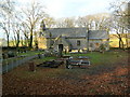
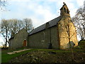
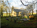
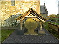
The cross-head dedicated to St Canna, has on it's front-side, a crucifixtion scene with Christ on the cross and a person at either side. The right hand figure could be holding up a swab on a long pole (St John) or it could be St Longinus the centurion piercing the side of Christ with his lance, whilst on the left side a figure with a strange-shaped head appears to be crouching down. This figure could be the devil. The figure below Christ seems to be stretching out his arms in thanksgiving and holding a small cross in his hand. The reverse side of the cross bears a plain Greek cross.
The churchyard is circular indicating that the site is a pre-Christian one. St Canna was a Breton princess, daughter of Tudur Mawr, who came to Wales in the 6th century with her husband, St Sadwrn, and her son, St Crallo. They became active Christian missionaries, each founding their own church. Near the church is Ffynnon Ganna - St Canna's Holy Well. There is another Llangan, in Dyfed, and it too is dedicated to this saint.
You may be viewing yesterday's version of this page. To see the most up to date information please register for a free account.
 (PID:74346)")
Do not use the above information on other web sites or publications without permission of the contributor.
Nearby Images from Geograph Britain and Ireland:
©2014(licence)
©2018(licence)
©2014(licence)
©2014(licence)
©2014(licence)
The above images may not be of the site on this page, they are loaded from Geograph.
Please Submit an Image of this site or go out and take one for us!
Click here to see more info for this site
Nearby sites
Key: Red: member's photo, Blue: 3rd party photo, Yellow: other image, Green: no photo - please go there and take one, Grey: site destroyed
Download sites to:
KML (Google Earth)
GPX (GPS waypoints)
CSV (Garmin/Navman)
CSV (Excel)
To unlock full downloads you need to sign up as a Contributory Member. Otherwise downloads are limited to 50 sites.
Turn off the page maps and other distractions
Nearby sites listing. In the following links * = Image available
1.8km N 4° Craig Tan-Y-Tan Hillfort (SS95867958)
1.9km ESE 123° Penllyn Wells* Holy Well or Sacred Spring (SS973767)
2.6km NW 317° St Crallog (Coychurch)* Ancient Cross (SS93997970)
2.6km NW 317° Ebissar Stone* Ancient Cross (SS93997971)
3.0km NNW 347° Ogof-Y-Pebyll* Cave or Rock Shelter (SS95108075)
3.2km SE 145° Corrwg Mounds (W) Cairn (SS97477518)
3.4km SE 140° Corrwg Mounds (E) Cairn (SS97857515)
4.0km NNW 332° Coed-Y-Gaer Hillfort (SS93918138)
4.5km NW 312° Simondston Cairn* Cairn (SS92378088)
4.9km NW 313° Bronze Age cremation cemetery, Coity Link Road Marker Stone (SS922812)
5.0km E 83° Mynydd Y Fforest Enclosure* Misc. Earthwork (ST007783)
5.1km NW 323° Coity* Chambered Cairn (SS92698193)
5.5km NW 307° Pond Cairn* Ring Cairn (SS914812)
5.5km NW 326° Pant-Y-Pyllau Ancient Village or Settlement (SS92728243)
5.7km WNW 286° Bridgend Recreation Centre* Standing Stone (Menhir) (SS90217951)
6.3km ESE 117° Stalling Down Tumulus Round Barrow(s) (ST012748)
6.4km SSE 157° St Anne's Well (Llanmihangel)* Holy Well or Sacred Spring (SS98117190)
6.4km SSE 157° Llanmihangel Early Christian Sculptured Stone (SS98137187)
6.5km NW 325° Cefn Hirgoed Misc. Earthwork (SS92068324)
6.8km W 271° Chapel Hill Camp Hillfort (SS88887806)
7.2km ESE 117° Llanquian Wood Fort Hillfort (ST021744)
7.3km NNE 12° Mynydd y Gaer* Hillfort (SS97358495)
7.6km W 263° Ogmore Cross Shaft* Early Christian Sculptured Stone (SS88177698)
7.7km WSW 249° Heol y Mynydd Round Barrow* Round Barrow(s) (SS8841275126)
8.0km N 356° Mynnydd y Gaer* Cairn (SS95378584)
View more nearby sites and additional images


 We would like to know more about this location. Please feel free to add a brief description and any relevant information in your own language.
 Wir möchten mehr über diese Stätte erfahren. Bitte zögern Sie nicht, eine kurze Beschreibung und relevante Informationen in Deutsch hinzuzufügen.
 Nous aimerions en savoir encore un peu sur les lieux. S'il vous plaît n'hesitez pas à ajouter une courte description et tous les renseignements pertinents dans votre propre langue.
 Quisieramos informarnos un poco más de las lugares. No dude en añadir una breve descripción y otros datos relevantes en su propio idioma.