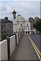
<< Our Photo Pages >> Perth Museum and Art Gallery - Museum in Scotland in Perth and Kinross
Submitted by vicky on Thursday, 21 June 2007 Page Views: 9536
MuseumsSite Name: Perth Museum and Art Gallery Alternative Name: Perth Art GalleryCountry: Scotland
NOTE: This site is 0.534 km away from the location you searched for.
County: Perth and Kinross Type: Museum
Nearest Town: Perth
Map Ref: NO119238 Landranger Map Number: 53
Latitude: 56.398210N Longitude: 3.428911W
Condition:
| 5 | Perfect |
| 4 | Almost Perfect |
| 3 | Reasonable but with some damage |
| 2 | Ruined but still recognisable as an ancient site |
| 1 | Pretty much destroyed, possibly visible as crop marks |
| 0 | No data. |
| -1 | Completely destroyed |
| 5 | Superb |
| 4 | Good |
| 3 | Ordinary |
| 2 | Not Good |
| 1 | Awful |
| 0 | No data. |
| 5 | Can be driven to, probably with disabled access |
| 4 | Short walk on a footpath |
| 3 | Requiring a bit more of a walk |
| 2 | A long walk |
| 1 | In the middle of nowhere, a nightmare to find |
| 0 | No data. |
| 5 | co-ordinates taken by GPS or official recorded co-ordinates |
| 4 | co-ordinates scaled from a detailed map |
| 3 | co-ordinates scaled from a bad map |
| 2 | co-ordinates of the nearest village |
| 1 | co-ordinates of the nearest town |
| 0 | no data |
Internal Links:
External Links:
")
An Archaeology Collection of tens of thousands of items
Address: 78 George Street, PH1 5LB
Phone: 01738 632488
Opening Hours: Open: Monday – Saturday 10am – 5pm, Closed: Christmas to New Year inclusive
Admission: Free
Visit their web site
You may be viewing yesterday's version of this page. To see the most up to date information please register for a free account.
")
")
")
Do not use the above information on other web sites or publications without permission of the contributor.
Nearby Images from Geograph Britain and Ireland:
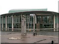
©2006(licence)
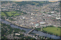
©2013(licence)
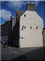
©2013(licence)
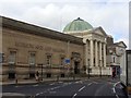
©2016(licence)
©2010(licence)
The above images may not be of the site on this page, they are loaded from Geograph.
Please Submit an Image of this site or go out and take one for us!
Click here to see more info for this site
Nearby sites
Key: Red: member's photo, Blue: 3rd party photo, Yellow: other image, Green: no photo - please go there and take one, Grey: site destroyed
Download sites to:
KML (Google Earth)
GPX (GPS waypoints)
CSV (Garmin/Navman)
CSV (Excel)
To unlock full downloads you need to sign up as a Contributory Member. Otherwise downloads are limited to 50 sites.
Turn off the page maps and other distractions
Nearby sites listing. In the following links * = Image available
nankm 0° Inchyra* Class I Pictish Symbol Stone (NO119238)
892m ENE 62° Murray Royal Hospital* Standing Stone (Menhir) (NO127242)
1.1km S 173° South Inch, Perth Standing Stone (Menhir) (NO12002274)
3.0km S 177° Craigclowan Standing Stone (Menhir) (NO12022083)
3.0km NNE 26° Sandy Road East Stone Circle (NO13282646)
3.0km NNE 26° Sandy Road* Stone Circle (NO1327526463)
3.2km SSW 194° Hilton Of Moncrieffe* Standing Stone (Menhir) (NO11062067)
3.4km SSW 196° Kirkton Hill Stone Circle (NO109205)
3.6km WNW 295° Hunting Tower Cursus (NO087254)
3.9km SSW 212° Callarfountain* Standing Stone (Menhir) (NO09752058)
4.1km SSE 161° Moncreiffe Hill* Hillfort (NO13131988)
4.1km NE 52° Murrayshall* Standing Stone (Menhir) (NO1519926265)
4.2km SSE 155° Moredun Top Hillfort (NO13621999)
4.2km N 354° Scone Cursus Cursus (NO11532797)
4.2km WNW 287° Mains Of Huntingtower Stone Circle (NO079251)
4.2km N 356° Scone Cursus Cursus (NO11712803)
4.6km NW 324° Whinny Hill Round Cairn (NO093276)
4.7km SSE 163° Moncrieffe Timber Circle (NO132193)
4.8km SSE 158° Moncrieffe* Stone Circle (NO13601933)
4.8km SSE 157° Boar Stone* Class III Pictish Cross Slab (NO13661933)
4.8km SSE 157° Gask House Class II Pictish Symbol Stone (NO13661933)
4.9km NW 324° Broxy Kennels* Hillfort (NO09112788)
5.0km NNW 333° King's Stone* Standing Stone (Menhir) (NO09712828)
5.0km NE 45° Shianbank SE* Stone Circle (NO15562729)
5.1km NE 45° Shianbank NW* Stone Circle (NO15552731)
View more nearby sites and additional images


 We would like to know more about this location. Please feel free to add a brief description and any relevant information in your own language.
 Wir möchten mehr über diese Stätte erfahren. Bitte zögern Sie nicht, eine kurze Beschreibung und relevante Informationen in Deutsch hinzuzufügen.
 Nous aimerions en savoir encore un peu sur les lieux. S'il vous plaît n'hesitez pas à ajouter une courte description et tous les renseignements pertinents dans votre propre langue.
 Quisieramos informarnos un poco más de las lugares. No dude en añadir una breve descripción y otros datos relevantes en su propio idioma.