<< Our Photo Pages >> St Illog's Well (Hirnant) - Holy Well or Sacred Spring in Wales in Powys
Submitted by Sunny100 on Wednesday, 18 January 2012 Page Views: 4555
Springs and Holy WellsSite Name: St Illog's Well (Hirnant) Alternative Name: Ffynnon HiseCountry: Wales
NOTE: This site is 2.082 km away from the location you searched for.
County: Powys Type: Holy Well or Sacred Spring
Nearest Town: Oswestry Nearest Village: Hirnant
Map Ref: SJ04902313
Latitude: 52.797320N Longitude: 3.41191W
Condition:
| 5 | Perfect |
| 4 | Almost Perfect |
| 3 | Reasonable but with some damage |
| 2 | Ruined but still recognisable as an ancient site |
| 1 | Pretty much destroyed, possibly visible as crop marks |
| 0 | No data. |
| -1 | Completely destroyed |
| 5 | Superb |
| 4 | Good |
| 3 | Ordinary |
| 2 | Not Good |
| 1 | Awful |
| 0 | No data. |
| 5 | Can be driven to, probably with disabled access |
| 4 | Short walk on a footpath |
| 3 | Requiring a bit more of a walk |
| 2 | A long walk |
| 1 | In the middle of nowhere, a nightmare to find |
| 0 | No data. |
| 5 | co-ordinates taken by GPS or official recorded co-ordinates |
| 4 | co-ordinates scaled from a detailed map |
| 3 | co-ordinates scaled from a bad map |
| 2 | co-ordinates of the nearest village |
| 1 | co-ordinates of the nearest town |
| 0 | no data |
Internal Links:
External Links:
 (PID:94448)")
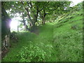
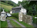
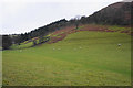
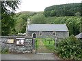
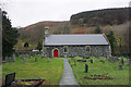
The tiny village of Hirnant is 6 miles north-west of Llanfyllin and 12 miles south-west of Oswestry. It can be reached by going north from the B4391 road and up a country lane to the church-cum-chapel of St Illog, a 6-7th century hermit. The holy well (Ffynnon Illog) is located some 300 yards northwest of the church beside a wooded area and just west of a caravan park.
According to Francis Jones in his work 'The Holy Wells Of Wales' 1992 the well "cured diverse diseases". Pins were thrown into the well which was much resorted to for its mineral power. Jones says that "it is now called Ffynnon Hise". The well pre-dates the local saint called Illog as does Carnedd Illog a tumulus on top of a nearby hill where the hermit saint was thought to be buried. The condition of the well is not known but it is still there.
The little church of St Illog houses what may be a pre-Conquest Font ?
You may be viewing yesterday's version of this page. To see the most up to date information please register for a free account.
Do not use the above information on other web sites or publications without permission of the contributor.
Nearby Images from Geograph Britain and Ireland:
©2012(licence)
©2012(licence)
©2016(licence)
©2012(licence)
©2016(licence)
The above images may not be of the site on this page, they are loaded from Geograph.
Please Submit an Image of this site or go out and take one for us!
Click here to see more info for this site
Nearby sites
Key: Red: member's photo, Blue: 3rd party photo, Yellow: other image, Green: no photo - please go there and take one, Grey: site destroyed
Download sites to:
KML (Google Earth)
GPX (GPS waypoints)
CSV (Garmin/Navman)
CSV (Excel)
To unlock full downloads you need to sign up as a Contributory Member. Otherwise downloads are limited to 50 sites.
Turn off the page maps and other distractions
Nearby sites listing. In the following links * = Image available
2.9km W 267° Afon y Dolau Gwynion* Chambered Tomb (SJ01952301)
3.3km SW 221° Groes y Forwm Round Cairn* Round Cairn (SJ0267020670)
3.9km SSW 212° Round Cairn South of Groes y Forwm* Round Cairn (SJ0273019850)
3.9km N 11° Craig Rhiwarth* Hillfort (SJ057270)
4.2km NW 323° Pennant Melangell Cross Ancient Cross (SJ02422654)
4.7km NNW 339° Craig ty-glas* Cairn (SJ03262758)
4.8km NNW 329° Ffynnon Cwm Ewyn* Holy Well or Sacred Spring (SJ025273)
4.9km N 9° Bedd Crynddyn* Cairn (SJ058280)
5.1km NNE 25° Glan Hafon cairn* Cairn (SJ07152776)
6.9km NNE 17° Afon Disgynfa* Cairn (SJ07042971)
7.1km N 6° Rhos Y Beddau (Circle)* Stone Circle (SJ058302)
7.1km N 6° Rhos y Beddau (Rows)* Multiple Stone Rows / Avenue (SJ0579530205)
7.4km N 7° Cwm Rhiwiau* Stone Circle (SJ059305)
7.9km ENE 68° St Dogfan's (Llanrhaeadr ym Mochnant)* Ancient Cross (SJ123260)
8.1km ENE 69° Llanrhaeadr ym Mochnant (Standing Stone)* Standing Stone (Menhir) (SJ1254425902)
8.7km ENE 75° Meusydd Henge Complex* Henge (SJ134252)
8.9km N 10° Moel Sych* Cairn (SJ066319)
8.9km ENE 78° Aber Rhaeadr* Standing Stone (Menhir) (SJ1369624820)
9.6km NNE 13° Cader Berwyn Cairn 2* Cairn (SJ07173245)
9.7km ESE 111° St Myllin's Well* Holy Well or Sacred Spring (SJ1393819533)
9.7km SW 220° Mynydd Dyfnant* Stone Row / Alignment (SH9852015742)
9.8km N 356° Nant Esgeiriau* Round Cairn (SJ044329)
9.8km NNE 22° Cwm Maen Gwynedd Stone Row I Stone Row / Alignment (SJ0881132142)
9.8km NNW 348° Yr Aran* Barrow Cemetery (SJ03053279)
9.8km NNE 12° Cadair Berwyn* Cairn (SJ072327)
View more nearby sites and additional images


 We would like to know more about this location. Please feel free to add a brief description and any relevant information in your own language.
 Wir möchten mehr über diese Stätte erfahren. Bitte zögern Sie nicht, eine kurze Beschreibung und relevante Informationen in Deutsch hinzuzufügen.
 Nous aimerions en savoir encore un peu sur les lieux. S'il vous plaît n'hesitez pas à ajouter une courte description et tous les renseignements pertinents dans votre propre langue.
 Quisieramos informarnos un poco más de las lugares. No dude en añadir una breve descripción y otros datos relevantes en su propio idioma.