<< Our Photo Pages >> St Margaret's Well (Edinburgh Castle) - Holy Well or Sacred Spring in Scotland in Midlothian
Submitted by KiwiBetsy on Wednesday, 27 September 2006 Page Views: 14019
Springs and Holy WellsSite Name: St Margaret's Well (Edinburgh Castle)Country: Scotland
NOTE: This site is 0.304 km away from the location you searched for.
County: Midlothian Type: Holy Well or Sacred Spring
Nearest Town: Edinburgh
Map Ref: NT2508273613
Latitude: 55.949686N Longitude: 3.201244W
Condition:
| 5 | Perfect |
| 4 | Almost Perfect |
| 3 | Reasonable but with some damage |
| 2 | Ruined but still recognisable as an ancient site |
| 1 | Pretty much destroyed, possibly visible as crop marks |
| 0 | No data. |
| -1 | Completely destroyed |
| 5 | Superb |
| 4 | Good |
| 3 | Ordinary |
| 2 | Not Good |
| 1 | Awful |
| 0 | No data. |
| 5 | Can be driven to, probably with disabled access |
| 4 | Short walk on a footpath |
| 3 | Requiring a bit more of a walk |
| 2 | A long walk |
| 1 | In the middle of nowhere, a nightmare to find |
| 0 | No data. |
| 5 | co-ordinates taken by GPS or official recorded co-ordinates |
| 4 | co-ordinates scaled from a detailed map |
| 3 | co-ordinates scaled from a bad map |
| 2 | co-ordinates of the nearest village |
| 1 | co-ordinates of the nearest town |
| 0 | no data |
Internal Links:
External Links:
I have visited· I would like to visit
lichen would like to visit
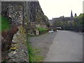
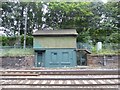
Anne T visited on 17th Dec 2015 - their rating: Cond: 3 Amb: 2 Access: 4 St. Margaret's Well, Edinburgh Castle: I arrived in Edinburgh on an early train but even at 08:45 it was wet and windy and too dark to see much. By 09:30, fortified by a cup of coffee, having met my old University friend, we set off towards the castle. The well sits on far side of the railway track, immediately under the castle and next to the footpath. The area is heavily littered, and without the image from the Portal I wouldn't have known this was a well. We braved the puddles to look inside the domed structure behind the plaque, but this was full of rubble and rubbish. Disappointing, but another well crossed off my 'to visit' list.
coldrum visited - their rating: Cond: 2 Amb: 4 Access: 4
schwagmyre have visited here
Average ratings for this site from all visit loggers: Condition: 2.5 Ambience: 3 Access: 4
 (PID:24414)")
The site of this well crouches beneath the rock on which Edinburgh Castle stands. It can be accessed on foot from the network of tracks that run both from the castle esplanade and from Princes Street Gardens.
For more information see Canmore ID 52080 which adds: "One of the two wells used by the Garrison of Kirkcaldy of Grange during the siege of 1573. Position of site is commemorated by drinking fountain."
You may be viewing yesterday's version of this page. To see the most up to date information please register for a free account.
 (PID:24415)")
 (PID:143475)")
 (PID:143474)")
 (PID:143473)")
Do not use the above information on other web sites or publications without permission of the contributor.
Nearby Images from Geograph Britain and Ireland:
©2012(licence)
©2007(licence)
©2009(licence)
©2009(licence)
©2017(licence)
The above images may not be of the site on this page, they are loaded from Geograph.
Please Submit an Image of this site or go out and take one for us!
Click here to see more info for this site
Nearby sites
Key: Red: member's photo, Blue: 3rd party photo, Yellow: other image, Green: no photo - please go there and take one, Grey: site destroyed
Download sites to:
KML (Google Earth)
GPX (GPS waypoints)
CSV (Garmin/Navman)
CSV (Excel)
To unlock full downloads you need to sign up as a Contributory Member. Otherwise downloads are limited to 50 sites.
Turn off the page maps and other distractions
Nearby sites listing. In the following links * = Image available
245m ESE 116° Stone of Scone* Marker Stone (NT253735)
376m SE 138° Grassmarket modern menhir* Standing Stone (Menhir) (NT25337333)
395m SSE 149° The Portsburgh Stone* Natural Stone / Erratic / Other Natural Feature (NT25287327)
709m ESE 115° National Museum of Scotland (Pictish Stones)* Museum (NT2572173302)
738m ESE 115° National Museum of Scotland* Museum (NT2574873290)
801m ESE 110° National Museum of Scotland (Early Christian Stones)* Ancient Cross (NT2583273324)
818m WNW 303° St George's Well (Edinburgh)* Holy Well or Sacred Spring (NT2440174070)
893m NW 314° St Bernard's Well* Holy Well or Sacred Spring (NT2445174247)
1.1km SE 126° Edinburgh Runestone* Carving (NT2598972937)
1.2km E 83° St John's Cross (Canongate)* Ancient Cross (NT2628873733)
1.4km E 81° Canongate Mercat Cross* Ancient Cross (NT2647273812)
1.7km E 79° Girth Cross (Canongate)* Ancient Cross (NT2673973910)
1.9km ESE 116° Slidey Stane (Holyrood Park)* Natural Stone / Erratic / Other Natural Feature (NT2676672765)
1.9km E 99° Salisbury Crags* Promontory Fort / Cliff Castle (NT27007326)
2.0km E 86° St Margaret's Well (Edinburgh)* Holy Well or Sacred Spring (NT2713373712)
2.1km SSW 195° The Bore Stone* Marker Stone (NT2450871568)
2.2km W 269° Succoth Place Double Cist Burial Cist (NT22897362)
2.2km SE 144° Penny Well (Edinburgh)* Holy Well or Sacred Spring (NT26367177)
2.4km E 88° St Anthony's Well (Edinburgh)* Holy Well or Sacred Spring (NT27527364)
2.6km ESE 114° Samson's Ribs* Promontory Fort / Cliff Castle (NT27457250)
2.7km ESE 106° Arthur's Seat* Hillfort (NT27647282)
3.1km S 190° Hanging Stanes (Braid Road)* Marker Stone (NT24517061)
3.1km E 97° Dunsapie Crag* Hillfort (NT28177316)
3.2km E 98° Holyrood Park Stone (Edinburgh) Natural Stone / Erratic / Other Natural Feature (NT28267313)
3.2km ESE 105° Delf Well* Holy Well or Sacred Spring (NT282727)
View more nearby sites and additional images


 We would like to know more about this location. Please feel free to add a brief description and any relevant information in your own language.
 Wir möchten mehr über diese Stätte erfahren. Bitte zögern Sie nicht, eine kurze Beschreibung und relevante Informationen in Deutsch hinzuzufügen.
 Nous aimerions en savoir encore un peu sur les lieux. S'il vous plaît n'hesitez pas à ajouter une courte description et tous les renseignements pertinents dans votre propre langue.
 Quisieramos informarnos un poco más de las lugares. No dude en añadir una breve descripción y otros datos relevantes en su propio idioma.