

<< Our Photo Pages >> Borgarvirki - Promontory Fort / Cliff Castle in Iceland
Submitted by KaiHofmann on Friday, 16 April 2010 Page Views: 5845
Iron Age and Later PrehistorySite Name: BorgarvirkiCountry: Iceland
NOTE: This site is 14.751 km away from the location you searched for.
Type: Promontory Fort / Cliff Castle
Nearest Town: Blönduós Nearest Village: Borg
Latitude: 65.474810N Longitude: 20.59663W
Condition:
| 5 | Perfect |
| 4 | Almost Perfect |
| 3 | Reasonable but with some damage |
| 2 | Ruined but still recognisable as an ancient site |
| 1 | Pretty much destroyed, possibly visible as crop marks |
| 0 | No data. |
| -1 | Completely destroyed |
| 5 | Superb |
| 4 | Good |
| 3 | Ordinary |
| 2 | Not Good |
| 1 | Awful |
| 0 | No data. |
| 5 | Can be driven to, probably with disabled access |
| 4 | Short walk on a footpath |
| 3 | Requiring a bit more of a walk |
| 2 | A long walk |
| 1 | In the middle of nowhere, a nightmare to find |
| 0 | No data. |
| 5 | co-ordinates taken by GPS or official recorded co-ordinates |
| 4 | co-ordinates scaled from a detailed map |
| 3 | co-ordinates scaled from a bad map |
| 2 | co-ordinates of the nearest village |
| 1 | co-ordinates of the nearest town |
| 0 | no data |
Internal Links:
External Links:
I have visited· I would like to visit
markj99 visited on 15th Nov 2015 - their rating: Cond: 3 Access: 4 I was fortunate to visit Borgarvirki Fort on the cusp of Winter, a fresh layer of snow adding atmosphere to an impressive site. Although my visit predated Game of Thrones it seems to me that Borgarvirki could easily have been transported from the icy wastes beyond The Wall.
")
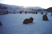
Additional text by CharcoalBurner89: Borgarvirki is one of the few forts discovered in Iceland to date. It is located in the western part of the Vestur-Húnavatnssýsla district and not far from the Hóp Lagoon in the north of the country. The fortress probably dates from the 10th or 11th century.
The fortress rests at a height of 177 m on a natural bulwark of basalt columns between Lake Vesturhópsvatn and Víðidalur. The 10-15 m high basalt columns form a fortress-like structure with a 5-6 m deep depression in the middle and an opening to the east. Further rock layers of 1 to 2 m in height and up to 30 m in length were piled up on top of the basalt columns.
In the middle you can see the remains of one or two huts from the Viking Age. The larger one measures 9 m × 4 m, the smaller one 8 m × 4 m. The remains of a well have also been discovered.
The Heiðarvíga saga, for example, tells of Barður Guðmundarsson and his quarrel with the Borgfirdingers. He is credited with building the Borgarvirki.
Another source refers to Finnbogur rammi, who lived at Stóra-Borg and was at odds with the Vatnsdælingers. A third story tells that the first settlers of the Ingimundur Gamli area had the Borgarvirki built as a job creation measure during the winter period. This is quite conceivable, although Ingimundur would certainly have thought more about protecting his property. In any case, according to the Vatnsdæla saga, it had its first settlement at the foot of Borgarvirki before finally settling in Vatnsdalur.
You may be viewing yesterday's version of this page. To see the most up to date information please register for a free account.
")
")
")
")
")
Do not use the above information on other web sites or publications without permission of the contributor.
Click here to see more info for this site
Nearby sites
Click here to view sites on an interactive map of the areaKey: Red: member's photo, Blue: 3rd party photo, Yellow: other image, Green: no photo - please go there and take one, Grey: site destroyed
Download sites to:
KML (Google Earth)
GPX (GPS waypoints)
CSV (Garmin/Navman)
CSV (Excel)
To unlock full downloads you need to sign up as a Contributory Member. Otherwise downloads are limited to 50 sites.
Turn off the page maps and other distractions
Nearby sites listing. In the following links * = Image available
110.2km WSW 245° Helgafell Natural Stone / Erratic / Other Natural Feature
115.7km ENE 73° Eyjafjörður Fjord* Artificial Mound
120.0km W 274° Flókatóftir Ancient Village or Settlement
121.2km SSW 211° Skallagrimshaugur* Round Barrow(s)
121.6km SSW 211° The Settlement Center Museum
137.1km S 191° Althing* Natural Stone / Erratic / Other Natural Feature
155.1km SSE 166° Þjóðveldisbærinn Ancient Village or Settlement
160.8km SSW 204° Reykjavik Settlement Museum* Museum
190.3km SSW 210° Vikingaheimar* Museum
222.5km SE 146° Hildishaugur Cairn
222.5km SSE 167° Rútshellir Cave or Rock Shelter
236.5km ENE 60° Arctic Henge Modern Stone Circle etc
238.0km ENE 58° Þorgeirsdys Cairn
245.4km SSE 158° Hjörleifshaugur Cairn
309.2km E 96° Völvuleiði Cairn
600.9km NNW 339° Danmark Ø Hut Foundations* Ancient Village or Settlement
759.5km ESE 113° Viking longhouse Kvívík, Faeröer Ancient Village or Settlement
769.0km ESE 112° Viking longhouse Leirvík, Faeröer Ancient Village or Settlement
903.7km NNW 348° Rendalen Hut Site* Ancient Village or Settlement
1035.5km SE 126° North Ronan Crosses Ancient Cross (HW80913231)
1056.1km SE 137° Boreray* Stone Circle (NA15060499)
1057.5km SE 138° Tobar nam Buadh (St Kilda) Holy Well or Sacred Spring (NA0864400247)
1057.7km SE 138° The Amazon's House (Hirta) Ancient Village or Settlement (NA08780010)
1058.3km SE 138° Gleann Mor* Standing Stones (NF08869943)
1058.9km SE 138° House Of The Fairies* Souterrain (Fogou, Earth House) (NF1001799410)
View more nearby sites and additional images


 We would like to know more about this location. Please feel free to add a brief description and any relevant information in your own language.
 Wir möchten mehr über diese Stätte erfahren. Bitte zögern Sie nicht, eine kurze Beschreibung und relevante Informationen in Deutsch hinzuzufügen.
 Nous aimerions en savoir encore un peu sur les lieux. S'il vous plaît n'hesitez pas à ajouter une courte description et tous les renseignements pertinents dans votre propre langue.
 Quisieramos informarnos un poco más de las lugares. No dude en añadir una breve descripción y otros datos relevantes en su propio idioma.