<< Text Pages >> Cattistock holy well - Holy Well or Sacred Spring in England in Dorset
Submitted by Merrily on Thursday, 11 August 2022 Page Views: 559
Springs and Holy WellsSite Name: Cattistock holy well Alternative Name: The baptismal poolCountry: England
NOTE: This site is 0.349 km away from the location you searched for.
County: Dorset Type: Holy Well or Sacred Spring
Nearest Town: Dorchester Nearest Village: Cattistock
Latitude: 50.793846N Longitude: 2.58093W
Condition:
| 5 | Perfect |
| 4 | Almost Perfect |
| 3 | Reasonable but with some damage |
| 2 | Ruined but still recognisable as an ancient site |
| 1 | Pretty much destroyed, possibly visible as crop marks |
| 0 | No data. |
| -1 | Completely destroyed |
| 5 | Superb |
| 4 | Good |
| 3 | Ordinary |
| 2 | Not Good |
| 1 | Awful |
| 0 | No data. |
| 5 | Can be driven to, probably with disabled access |
| 4 | Short walk on a footpath |
| 3 | Requiring a bit more of a walk |
| 2 | A long walk |
| 1 | In the middle of nowhere, a nightmare to find |
| 0 | No data. |
| 5 | co-ordinates taken by GPS or official recorded co-ordinates |
| 4 | co-ordinates scaled from a detailed map |
| 3 | co-ordinates scaled from a bad map |
| 2 | co-ordinates of the nearest village |
| 1 | co-ordinates of the nearest town |
| 0 | no data |
Internal Links:
External Links:
Holy Well or Sacred Spring in England
This lovely well is much used and venerated locally - witness the amount of coins in it. Probably a foundation spring of its ancient church, which dates back to Saxon times, and no doubt farther back than that. It lies on two important leys:
The first was discovered by John Michell
From NE to SW
From Old Sarum
Iwerne Minster
Hambledon Hill Fort
Child Okeford church and site of former stone
Brockhampton Green, stone with folklore
Minterne Parva stone (now a cross)
Stagg’s Folly crossroads
Cattistock church
Toller Porcorum church
Tumulus
Powerstock motte and bailey
From ENE to WSW
Tarrant Keyneston church
Winterborne Clenston church
Milton Abbas abbey and crosses
Summit of Henning Hill
Giant’s grave stone
Cross dykes
Black Hill summit and settlement
Dickley Hill
Folly Hill
Cattistock Church
Mount Pleasant, meeting of 5 tracks
Earthworks
Jack’s Hill
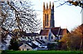
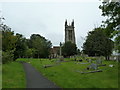
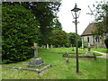
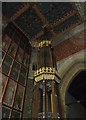
The church of St. Peter and St. Paul has been thoroughly Victorianised, but by the famous architects George Gilbert Scott, snr and jnr, and is therefore a magnificent example of the genre for Dorset, and is well worth a visit. Of note are the William Morris windows. The holy well has been Victorianised too, but this is entirely to its benefit - a graceful and restrained renovation. The well is just inside the churchyard, beside the public footpath which leads south from it.
What3words address is ///newlywed.quenched.striving
You may be viewing yesterday's version of this page. To see the most up to date information please register for a free account.
")
Do not use the above information on other web sites or publications without permission of the contributor.
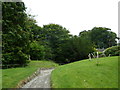
Nearby Images from Geograph Britain and Ireland:
©2011(licence)
©2012(licence)
©2012(licence)
©2012(licence)
©2012(licence)
The above images may not be of the site on this page, they are loaded from Geograph.
Please Submit an Image of this site or go out and take one for us!
Click here to see more info for this site
Nearby sites
Click here to view sites on an interactive map of the areaKey: Red: member's photo, Blue: 3rd party photo, Yellow: other image, Green: no photo - please go there and take one, Grey: site destroyed
Download sites to:
KML (Google Earth)
GPX (GPS waypoints)
CSV (Garmin/Navman)
CSV (Excel)
To unlock full downloads you need to sign up as a Contributory Member. Otherwise downloads are limited to 50 sites.
Turn off the page maps and other distractions
Nearby sites listing. In the following links * = Image available
626m NNE 23° The Castle Hillfort (ST594001)
3.2km SE 139° Hog Cliff Bottom Barrow Round Barrow(s) (SY61209711)
3.2km E 86° The Combe (Dorset) Misc. Earthwork (SY624997)
3.4km WSW 241° Toller Porcorum* Standing Stones (SY561979)
3.6km WNW 287° Wraxall Cromlech Burial Chamber or Dolmen (ST557006)
4.1km SE 132° Hog Cliff Hill Barrow Round Barrow(s) (SY62179676)
4.4km SE 133° Hog Cliff Hill Settlement Ancient Village or Settlement (SY624965)
5.0km SSE 159° Notton Down Barrow Round Barrow(s) (SY60949486)
5.4km NNW 343° Evershot Stones* Standing Stones (ST57600469)
5.4km NNW 339° St John's Well (Evershot)* Holy Well or Sacred Spring (ST5721304596)
5.6km ENE 77° Up Cerne/Sydling St Nicholas Boundary Stone Marker Stone (ST64610078)
5.9km NE 43° Cross and Hand Stone* Standing Stone (Menhir) (ST632038)
6.1km ENE 66° Wancombe Hill Field System Misc. Earthwork (ST64790200)
6.3km SSW 196° West Compton Fort Hillfort (SY574935)
6.3km ESE 121° Jackman's Cross Bowl Barrow Round Barrow(s) (SY64559623)
6.5km E 83° Dickley Hill Bowl Barrows Round Barrow(s) (ST65600026)
6.5km E 83° Dickley Hill Settlement Ancient Village or Settlement (ST65650027)
6.5km ESE 114° Crete Hill Field System Misc. Earthwork (SY651968)
6.5km E 91° Smacam Down Settlement Ancient Village or Settlement (SY657994)
6.6km E 91° Smacam Down Long Barrow Long Barrow (SY6572599389)
6.6km SSW 202° West Compton Bowl Barrow Round Barrow(s) (SY56619347)
6.6km ENE 71° Weam Commen Hill Field System Misc. Earthwork (ST654016)
6.6km ENE 64° Seldon Hill Settlement Ancient Village or Settlement (ST65100235)
6.6km ESE 108° Furzey Down Road Ancient Trackway (SY654974)
6.6km SE 127° Grimstone Down Barrow Cemetery Barrow Cemetery (SY644955)
View more nearby sites and additional images


 We would like to know more about this location. Please feel free to add a brief description and any relevant information in your own language.
 Wir möchten mehr über diese Stätte erfahren. Bitte zögern Sie nicht, eine kurze Beschreibung und relevante Informationen in Deutsch hinzuzufügen.
 Nous aimerions en savoir encore un peu sur les lieux. S'il vous plaît n'hesitez pas à ajouter une courte description et tous les renseignements pertinents dans votre propre langue.
 Quisieramos informarnos un poco más de las lugares. No dude en añadir una breve descripción y otros datos relevantes en su propio idioma.