<< Our Photo Pages >> The Bear Stone - Natural Stone / Erratic / Other Natural Feature in England in Cheshire
Submitted by TimPrevett on Tuesday, 17 October 2006 Page Views: 7955
Natural PlacesSite Name: The Bear StoneCountry: England
NOTE: This site is 5.054 km away from the location you searched for.
County: Cheshire Type: Natural Stone / Erratic / Other Natural Feature
Nearest Town: Audlem
Map Ref: SJ66004365
Latitude: 52.989097N Longitude: 2.507936W
Condition:
| 5 | Perfect |
| 4 | Almost Perfect |
| 3 | Reasonable but with some damage |
| 2 | Ruined but still recognisable as an ancient site |
| 1 | Pretty much destroyed, possibly visible as crop marks |
| 0 | No data. |
| -1 | Completely destroyed |
| 5 | Superb |
| 4 | Good |
| 3 | Ordinary |
| 2 | Not Good |
| 1 | Awful |
| 0 | No data. |
| 5 | Can be driven to, probably with disabled access |
| 4 | Short walk on a footpath |
| 3 | Requiring a bit more of a walk |
| 2 | A long walk |
| 1 | In the middle of nowhere, a nightmare to find |
| 0 | No data. |
| 5 | co-ordinates taken by GPS or official recorded co-ordinates |
| 4 | co-ordinates scaled from a detailed map |
| 3 | co-ordinates scaled from a bad map |
| 2 | co-ordinates of the nearest village |
| 1 | co-ordinates of the nearest town |
| 0 | no data |
Internal Links:
External Links:
I have visited· I would like to visit
BrownEdger visited on 1st Jan 2012 - their rating: Cond: 4 Amb: 3 Access: 5
TimPrevett have visited here
")
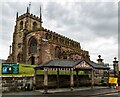
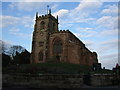
A glacial erratic stone brought to the locale by the movement of the ice during the ice age. Selected for use as a bear bating stone from which the beasts were secured by an iron ring in a lead plug. Originally located in the centre of the village in the middle of the market place where a taller memorial now stands. It is now situated between the historic buttermarket, a litter bin, and the imposing mound based Parish Church of St James the Great.
You may be viewing yesterday's version of this page. To see the most up to date information please register for a free account.
")
")
")
Do not use the above information on other web sites or publications without permission of the contributor.
Nearby Images from Geograph Britain and Ireland:
©2023(licence)
©2011(licence)
©2010(licence)

©2012(licence)

©2014(licence)
The above images may not be of the site on this page, they are loaded from Geograph.
Please Submit an Image of this site or go out and take one for us!
Click here to see more info for this site
Nearby sites
Key: Red: member's photo, Blue: 3rd party photo, Yellow: other image, Green: no photo - please go there and take one, Grey: site destroyed
Download sites to:
KML (Google Earth)
GPX (GPS waypoints)
CSV (Garmin/Navman)
CSV (Excel)
To unlock full downloads you need to sign up as a Contributory Member. Otherwise downloads are limited to 50 sites.
Turn off the page maps and other distractions
Nearby sites listing. In the following links * = Image available
nankm 0° St James the Great, Audlem* Round Barrow(s) (SJ66004365)
6.6km SE 139° Bradling Stone* Standing Stone (Menhir) (SJ70333864)
7.5km SSE 154° Betton Standing Stone (Menhir) (SJ69193691)
7.5km SE 141° Devil's Ring and Finger* Holed Stone (SJ7072737783)
7.8km SSE 147° The Ineaz Stone Standing Stone (Menhir) (SJ70223706)
8.0km SE 146° The Blew Stone Standing Stone (Menhir) (SJ705370)
8.8km N 353° Old Biot* Holy Well or Sacred Spring (SJ64965243)
9.8km NNW 343° Church of St Mary the Virgin (Acton)* Ancient Cross (SJ63175308)
13.1km SE 139° Bishop's Wood Hillfort (SJ745336)
13.5km ESE 109° Berth Hill* Hillfort (SJ788391)
16.1km W 264° Warren Tump (Wrexham)* Round Barrow(s) (SJ49974206)
16.5km W 262° Whitewell 1* Round Barrow(s) (SJ49564160)
16.6km W 262° Whitewell (St Marys)* Holy Well or Sacred Spring (SJ49484137)
17.2km SW 222° Soulton Long Barrow* Modern Stone Circle etc (SJ5441330922)
18.1km SSW 207° Bury Walls* Hillfort (SJ577275)
18.3km NW 320° Peckforton Mere* Ancient Village or Settlement (SJ543577)
18.3km NNW 332° Robin Hood's Tump* Round Barrow(s) (SJ575599)
18.6km WNW 299° Maiden Castle (Cheshire)* Hillfort (SJ49805286)
18.7km WSW 241° Lady Well (Whixall)* Holy Well or Sacred Spring (SJ496346)
18.9km E 83° Market Cross (Newcastle-under-Lyme) Ancient Cross (SJ8485745979)
19.0km SE 133° St. Catherine's Well (Sugnall)* Holy Well or Sacred Spring (SJ798306)
19.0km NE 50° Church Lawton South* Stone Circle (SJ808557)
19.2km W 271° Oldcastle* Hillfort (SJ468441)
19.3km NE 50° Church Lawton Barrows* Barrow Cemetery (SJ809559)
19.7km W 262° Bryn Rossett* Round Barrow(s) (SJ46454095)
View more nearby sites and additional images


 We would like to know more about this location. Please feel free to add a brief description and any relevant information in your own language.
 Wir möchten mehr über diese Stätte erfahren. Bitte zögern Sie nicht, eine kurze Beschreibung und relevante Informationen in Deutsch hinzuzufügen.
 Nous aimerions en savoir encore un peu sur les lieux. S'il vous plaît n'hesitez pas à ajouter une courte description et tous les renseignements pertinents dans votre propre langue.
 Quisieramos informarnos un poco más de las lugares. No dude en añadir una breve descripción y otros datos relevantes en su propio idioma.