


<< Text Pages >> Norman Arch over Well - Holy Well or Sacred Spring in England in Lancashire
Submitted by cactus_chris on Monday, 06 May 2024 Page Views: 11
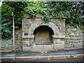
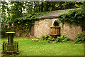
Springs and Holy WellsSite Name: Norman Arch over WellCountry: England
NOTE: This site is 3.218 km away from the location you searched for.
County: Lancashire Type: Holy Well or Sacred Spring
Nearest Town: Blackburn Nearest Village: Tockholes
Map Ref: SD6606023393
Latitude: 53.705853N Longitude: 2.515623W
Condition:
| 5 | Perfect |
| 4 | Almost Perfect |
| 3 | Reasonable but with some damage |
| 2 | Ruined but still recognisable as an ancient site |
| 1 | Pretty much destroyed, possibly visible as crop marks |
| 0 | No data. |
| -1 | Completely destroyed |
| 5 | Superb |
| 4 | Good |
| 3 | Ordinary |
| 2 | Not Good |
| 1 | Awful |
| 0 | No data. |
| 5 | Can be driven to, probably with disabled access |
| 4 | Short walk on a footpath |
| 3 | Requiring a bit more of a walk |
| 2 | A long walk |
| 1 | In the middle of nowhere, a nightmare to find |
| 0 | No data. |
| 5 | co-ordinates taken by GPS or official recorded co-ordinates |
| 4 | co-ordinates scaled from a detailed map |
| 3 | co-ordinates scaled from a bad map |
| 2 | co-ordinates of the nearest village |
| 1 | co-ordinates of the nearest town |
| 0 | no data |
Internal Links:
External Links:
I have visited· I would like to visit
cactus_chris visited on 6th May 2024 - their rating: Cond: 5 Amb: 5 Access: 5
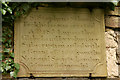
Inscription says: The Norman Arch over this well was removed from Gerstane Hall, Tockholes and placed here in 1910 by the Revd A. T. Corfield, Vicar.
You may be viewing yesterday's version of this page. To see the most up to date information please register for a free account.
")
")
Do not use the above information on other web sites or publications without permission of the contributor.
Nearby Images from Geograph Britain and Ireland:
©2008(licence)
©2007(licence)

©2008(licence)
©2012(licence)
©2007(licence)
The above images may not be of the site on this page, they are loaded from Geograph.
Please Submit an Image of this site or go out and take one for us!
Click here to see more info for this site
Nearby sites
Key: Red: member's photo, Blue: 3rd party photo, Yellow: other image, Green: no photo - please go there and take one, Grey: site destroyed
Download sites to:
KML (Google Earth)
GPX (GPS waypoints)
CSV (Garmin/Navman)
CSV (Excel)
To unlock full downloads you need to sign up as a Contributory Member. Otherwise downloads are limited to 50 sites.
Turn off the page maps and other distractions
Nearby sites listing. In the following links * = Image available
433m SSW 210° Tocca's Stone* Ancient Cross (SD65842302)
3.5km S 175° Hollinshead Holy Well* Holy Well or Sacred Spring (SD66361994)
4.0km NNW 343° Pleasington Cemetery (Blackburn) Cairn (SD649272)
4.4km SE 126° White Hall* Round Barrow(s) (SD696208)
5.7km SSW 203° Round Loaf* Artificial Mound (SD638182)
6.1km NNE 12° Revidge Moor Barrow* Round Barrow(s) (SD674293)
6.2km SW 219° Black Coppice Chambered Cairn* Chambered Cairn (SD621186)
6.4km N 7° Beardwood Holed Stone* Holed Stone (SD6684829793)
7.1km SSW 208° Pikestones* Chambered Cairn (SD62691719)
7.6km W 262° St Helen's Well (Whittle-le-Woods) Holy Well or Sacred Spring (SD58552242)
7.7km N 353° Mellor Brow Mound* Misc. Earthwork (SD6517231081)
8.0km ENE 75° Cocker Cobb* Stone Circle (SD7385225360)
8.4km S 183° Winter Hill Cairn* Cairn (SD65581499)
8.5km S 189° Noon Hill Slack* Cairn (SD64691499)
8.7km W 274° Hawksclough Hillfort (SD574240)
9.4km SE 143° Cheetham Close* Stone Circle (SD71631586)
9.4km S 173° Counting Hill Row* Stone Row / Alignment (SD672141)
9.4km S 174° Counting Hill Ringcairn Ring Cairn (SD670140)
9.7km S 190° Rivington Pike* Cairn (SD64311382)
10.0km WSW 239° Astley Hall Farm Bronze Age Burial Round Barrow(s) (SD574183)
10.0km NNW 327° Marsden Well/Spring* Holy Well or Sacred Spring (SD607319)
10.1km S 183° Two Lads (Rivington)* Cairn (SD65541330)
10.1km SSE 165° Horrocks Moor Barrow* Artificial Mound (SD687136)
10.2km S 177° Holden's Farm Ring Cairn (SD665132)
10.2km SSE 168° Moortop Barrows* Round Barrow(s) (SD682134)
View more nearby sites and additional images


 We would like to know more about this location. Please feel free to add a brief description and any relevant information in your own language.
 Wir möchten mehr über diese Stätte erfahren. Bitte zögern Sie nicht, eine kurze Beschreibung und relevante Informationen in Deutsch hinzuzufügen.
 Nous aimerions en savoir encore un peu sur les lieux. S'il vous plaît n'hesitez pas à ajouter une courte description et tous les renseignements pertinents dans votre propre langue.
 Quisieramos informarnos un poco más de las lugares. No dude en añadir una breve descripción y otros datos relevantes en su propio idioma.