

<< Our Photo Pages >> Faldouet Dolmen - Burial Chamber or Dolmen in Channel Islands and Isle of Man in Jersey
Submitted by enkidu41 on Wednesday, 11 November 2020 Page Views: 21130
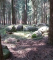
Neolithic and Bronze AgeSite Name: Faldouet Dolmen Alternative Name: La Pouquelaye de Faldouet, La Pouquelaye de Faldouët, Faldouët DolmenCountry: Channel Islands and Isle of Man
NOTE: This site is 0.665 km away from the location you searched for.
Island: Jersey Type: Burial Chamber or Dolmen
Latitude: 49.202959N Longitude: 2.026842W
Condition:
| 5 | Perfect |
| 4 | Almost Perfect |
| 3 | Reasonable but with some damage |
| 2 | Ruined but still recognisable as an ancient site |
| 1 | Pretty much destroyed, possibly visible as crop marks |
| 0 | No data. |
| -1 | Completely destroyed |
| 5 | Superb |
| 4 | Good |
| 3 | Ordinary |
| 2 | Not Good |
| 1 | Awful |
| 0 | No data. |
| 5 | Can be driven to, probably with disabled access |
| 4 | Short walk on a footpath |
| 3 | Requiring a bit more of a walk |
| 2 | A long walk |
| 1 | In the middle of nowhere, a nightmare to find |
| 0 | No data. |
| 5 | co-ordinates taken by GPS or official recorded co-ordinates |
| 4 | co-ordinates scaled from a detailed map |
| 3 | co-ordinates scaled from a bad map |
| 2 | co-ordinates of the nearest village |
| 1 | co-ordinates of the nearest town |
| 0 | no data |
Internal Links:
External Links:
I have visited· I would like to visit
DrewParsons JerseyArchaeology would like to visit
Chrus visited on 1st Jan 2016 - their rating: Cond: 3 Amb: 5 Access: 4
lscollinson visited on 24th Jun 2007 - their rating: Cond: 2 Amb: 4 Access: 4 A fantastic site with an impressive capstone.
attlebax MAIGO AngieLake have visited here
Average ratings for this site from all visit loggers: Condition: 2.5 Ambience: 4.5 Access: 4
")
It is likely that the horseshoe chamber was the original passage grave whose passage was dug out to make way for a second passage grave. In 1910 the floor was raised so the height is lower than originally. It is felt unlikely that the passage and central area were ever roofed.
Grid reference 70995069
More at Faldouet Dolmen.
Note: One of the stones that forms part of the ancient dolmen of Faldouet has been drilled into, leaving a hole of several inches, in an apparent attempt to extract quartz crystals... See comment on this page.
You may be viewing yesterday's version of this page. To see the most up to date information please register for a free account.
")
")
")
")
")
")
")
")
")
")
")
")
")
")
")
")
")
")
")
")
")
")
")
Do not use the above information on other web sites or publications without permission of the contributor.
Click here to see more info for this site
Nearby sites
Click here to view sites on an interactive map of the areaKey: Red: member's photo, Blue: 3rd party photo, Yellow: other image, Green: no photo - please go there and take one, Grey: site destroyed
Download sites to:
KML (Google Earth)
GPX (GPS waypoints)
CSV (Garmin/Navman)
CSV (Excel)
To unlock full downloads you need to sign up as a Contributory Member. Otherwise downloads are limited to 50 sites.
Turn off the page maps and other distractions
Nearby sites listing. In the following links * = Image available
2.7km W 264° La Hougue Bie* Chambered Tomb
3.5km N 350° Le Couperon* Passage Grave
4.5km WSW 247° Les Varines* Ancient Village or Settlement
4.6km SW 226° Le Mont Ubé* Passage Grave
5.1km SW 221° La Dame Blanche* Standing Stone (Menhir)
6.0km SW 218° La Motte (Jersey)* Cist
6.7km NW 318° La Roche a la Fee* Cist
7.3km NW 313° La Hougue des Platons* Chambered Tomb
7.6km W 265° Ville ès Nouaux* Burial Chamber or Dolmen
9.5km WNW 296° La Hougue Boëte* Chambered Tomb
10.7km WSW 252° La Hougue de Vinde* Chambered Tomb
12.1km WSW 255° La Cotte de St Brelade* Cave or Rock Shelter
13.6km W 268° La Tête des Quennevais Ancient Village or Settlement
13.8km W 268° Broken Menhir, The* Standing Stone (Menhir)
13.8km W 268° The Ossuary* Chambered Tomb
13.8km W 266° Great Menhir, The* Standing Stone (Menhir)
13.9km W 268° Little Menhir, The* Standing Stone (Menhir)
13.9km W 274° The White Menhir Standing Stone (Menhir)
13.9km W 275° Les Trois Rocques* Standing Stones
13.9km W 259° The Beauport Dolmen Chambered Tomb
14.4km W 264° La Rocque ès Jovaies* Standing Stone (Menhir)
14.6km WNW 283° Les Mont de Grantez* Passage Grave
14.6km WNW 291° La Hougue des Géonnais* Passage Grave
15.0km W 263° La Sergenté* Passage Grave
15.5km W 261° La Table des Marthes* Natural Stone / Erratic / Other Natural Feature
View more nearby sites and additional images


 We would like to know more about this location. Please feel free to add a brief description and any relevant information in your own language.
 Wir möchten mehr über diese Stätte erfahren. Bitte zögern Sie nicht, eine kurze Beschreibung und relevante Informationen in Deutsch hinzuzufügen.
 Nous aimerions en savoir encore un peu sur les lieux. S'il vous plaît n'hesitez pas à ajouter une courte description et tous les renseignements pertinents dans votre propre langue.
 Quisieramos informarnos un poco más de las lugares. No dude en añadir una breve descripción y otros datos relevantes en su propio idioma.