

<< Our Photo Pages >> Sumas Lightning Rock - Natural Stone / Erratic / Other Natural Feature in Canada
Submitted by TheDruid-3X3 on Sunday, 14 June 2020 Page Views: 2624
Natural PlacesSite Name: Sumas Lightning Rock Alternative Name: Lightning RockCountry: Canada
NOTE: This site is 16.238 km away from the location you searched for.
Type: Natural Stone / Erratic / Other Natural Feature
Nearest Town: Abbotsford, BC Nearest Village: Sumas, WA
Latitude: 49.063056N Longitude: 122.176944W
Condition:
| 5 | Perfect |
| 4 | Almost Perfect |
| 3 | Reasonable but with some damage |
| 2 | Ruined but still recognisable as an ancient site |
| 1 | Pretty much destroyed, possibly visible as crop marks |
| 0 | No data. |
| -1 | Completely destroyed |
| 5 | Superb |
| 4 | Good |
| 3 | Ordinary |
| 2 | Not Good |
| 1 | Awful |
| 0 | No data. |
| 5 | Can be driven to, probably with disabled access |
| 4 | Short walk on a footpath |
| 3 | Requiring a bit more of a walk |
| 2 | A long walk |
| 1 | In the middle of nowhere, a nightmare to find |
| 0 | No data. |
| 5 | co-ordinates taken by GPS or official recorded co-ordinates |
| 4 | co-ordinates scaled from a detailed map |
| 3 | co-ordinates scaled from a bad map |
| 2 | co-ordinates of the nearest village |
| 1 | co-ordinates of the nearest town |
| 0 | no data |
Internal Links:
External Links:
")
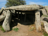
Lightning Rock is a sacred site to the Semá:th (Sumas) First Nation in the Fraser Valley. Thousands of people may be buried nearby, including victims of two smallpox epidemics that decimated First Nations in the 18th and 19th centuries.
But it isn’t designated a provincial heritage site, because it slips between the cracks of heritage regulations.
The name Lightning Rock comes from Semá:th oral tradition that the rock was a shaman who got into a conflict with Thunderbird, a powerful creature in First Nations lore that lived in a cave up Sumas Mountain. Thunderbird threw a lightning bolt at the shaman, who was split into the four pieces of Lightning Rock.
You may be viewing yesterday's version of this page. To see the most up to date information please register for a free account.
")
")
")
Do not use the above information on other web sites or publications without permission of the contributor.
Nearby Images from Flickr
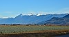
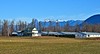
The above images may not be of the site on this page, but were taken nearby. They are loaded from Flickr so please click on them for image credits.
Click here to see more info for this site
Nearby sites
Click here to view sites on an interactive map of the areaKey: Red: member's photo, Blue: 3rd party photo, Yellow: other image, Green: no photo - please go there and take one, Grey: site destroyed
Download sites to:
KML (Google Earth)
GPX (GPS waypoints)
CSV (Garmin/Navman)
CSV (Excel)
To unlock full downloads you need to sign up as a Contributory Member. Otherwise downloads are limited to 50 sites.
Turn off the page maps and other distractions
Nearby sites listing. In the following links * = Image available
11.2km NNW 331° Xaytem Ancient Native Settlement* Ancient Village or Settlement
45.8km W 264° P'Quals White Rock* Natural Stone / Erratic / Other Natural Feature
56.3km WNW 282° Glenrose Cannery* Ancient Village or Settlement
56.6km W 281° Sewqueqsen Settlement at St.Mungo Cannery* Ancient Village or Settlement
67.8km W 267° Tsawwassen Long House Site* Ancient Village or Settlement
74.3km WNW 291° Xwayzway Village* Ancient Village or Settlement
76.1km WNW 292° Coast Salish Stone Fish Weir* Stone Row / Alignment
76.2km WNW 291° Skalsh Rock* Rock Outcrop
81.9km WNW 287° Museum of Anthropology - University of British Columbia* Museum
112.6km W 275° Degnen Bay Site* Rock Art
119.1km W 274° Cedar by the Sea Petroglyphs* Rock Art
120.8km W 277° Lock Bay Site* Rock Art
122.9km WNW 292° shíshálh Nation tems swiya Museum Museum
127.6km W 275° Petroglyph Provincial Park (British Columbia)* Rock Art
130.2km WNW 300° Salmon Inlet Barrow Cemetery
130.8km SW 230° Race Rocks Ecological Reserve* Ring Cairn
140.3km SW 223° Tse-whit-zen Barrow Cemetery
151.9km S 190° Haleets* Rock Art
156.2km S 184° Burke Museum of Natural History and Culture* Museum
190.6km WNW 298° Pictographs near Powell River ferry terminal Rock Art
195.2km WSW 247° Makah Cultural and Research Center Museum
201.0km W 278° Sproat Lake Petroglyphs* Rock Art
212.2km S 180° Skystone* Natural Stone / Erratic / Other Natural Feature
212.5km WSW 243° Ozette Ancient Village or Settlement
212.6km WNW 290° Comox Estuary* Ancient Village or Settlement
View more nearby sites and additional images


 We would like to know more about this location. Please feel free to add a brief description and any relevant information in your own language.
 Wir möchten mehr über diese Stätte erfahren. Bitte zögern Sie nicht, eine kurze Beschreibung und relevante Informationen in Deutsch hinzuzufügen.
 Nous aimerions en savoir encore un peu sur les lieux. S'il vous plaît n'hesitez pas à ajouter une courte description et tous les renseignements pertinents dans votre propre langue.
 Quisieramos informarnos un poco más de las lugares. No dude en añadir una breve descripción y otros datos relevantes en su propio idioma.