 with our Megalithic Portal iPhone app")


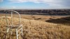
<< Our Photo Pages >> Majorville Medicine Wheel - Round Cairn in Canada
Submitted by Andy B on Monday, 10 January 2022 Page Views: 53262
Neolithic and Bronze AgeSite Name: Majorville Medicine Wheel Alternative Name: Iniskim Umaapi, Sundial Medicine Wheel, 'Canada's Stonehenge'Country: Canada Type: Round Cairn
Nearest Town: Calgary Nearest Village: Milo
Latitude: 50.585167N Longitude: 112.410639W
Condition:
| 5 | Perfect |
| 4 | Almost Perfect |
| 3 | Reasonable but with some damage |
| 2 | Ruined but still recognisable as an ancient site |
| 1 | Pretty much destroyed, possibly visible as crop marks |
| 0 | No data. |
| -1 | Completely destroyed |
| 5 | Superb |
| 4 | Good |
| 3 | Ordinary |
| 2 | Not Good |
| 1 | Awful |
| 0 | No data. |
| 5 | Can be driven to, probably with disabled access |
| 4 | Short walk on a footpath |
| 3 | Requiring a bit more of a walk |
| 2 | A long walk |
| 1 | In the middle of nowhere, a nightmare to find |
| 0 | No data. |
| 5 | co-ordinates taken by GPS or official recorded co-ordinates |
| 4 | co-ordinates scaled from a detailed map |
| 3 | co-ordinates scaled from a bad map |
| 2 | co-ordinates of the nearest village |
| 1 | co-ordinates of the nearest town |
| 0 | no data |
Internal Links:
External Links:
I have visited· I would like to visit
MartinJEley JoyN would like to visit
")
The central cairn is nine metres in diameter and is surrounded by a stone circle 27 metre across. about 28 spokes link the circle and central cairn. In 1971 an excavation yielded artifacts which were "dated" by stone tool style. This method and radiocarbon dating of bone place initial construction of the central cairn at some 4,500 BP, although another source dates the initial site to 3200 BP. The tool finds indicate a succession of added material over the centuries.
The site became known to the world in 2009 when academic Gordon Freeman published a book stating his theory that the site was an astronomical calendar on par with Stonehenge. Canadian Press story no longer available at their site: "An academic maverick is challenging conventional wisdom on Canada's prehistory by claiming an archeological site in southern Alberta is really a vast, open-air sun temple with a precise 5,000-year-old calendar predating England's Stonehenge and Egypt's pyramids."
"Mainstream archaeologists consider the rock-encircled cairn to be just another medicine wheel left behind by early aboriginals. But a new book by retired University of Alberta professor Gordon Freeman says it is in fact the centre of a 26-square-kilometre stone "lacework" that marks the changing seasons and the phases of the moon with greater accuracy than our current calendar.
"'Genius existed on the prairies 5,000 years ago,' says Freeman, the widely published former head of the university's physical and theoretical chemistry department.
"Freeman's fascination with prairie prehistory dates back to his Saskatchewan boyhood. He and his father would comb the short grasses of the plains in search of artifacts exposed by the scouring wind. That curiosity never left him and he returned to it as he prepared to retire from active teaching.
"Looking for a hobby, he asked a friend with an interest in history to suggest a few intriguing sites to visit. On a warm late-August day in 1980, that list drew him to what he has come to call Canada's Stonehenge, which is also the title of his book.
"A central cairn atop one of a series of low hills overlooking the Bow River, about 70 kilometres east of Calgary, had been partially excavated in 1971 and dated at about 5,000 years old. But as he approached it, Freeman strongly felt there was much more there than previously thought.
"'As we walked toward the hilltop, I saw all kinds of patterns in the rocks on the way up. As I walked around the hilltop, I could see patterns that I doubted very much were accidental.'"
Also see Freeman's own web site.
IMPORTANT NOTE: Location given is an estimate. The Majorville Cairn or Medicine Wheel is east of the village of Milo, Alberta, on the west side of the Bow River.
Note: "Canada's Stonehenge". Iniskim Umaapi medicine wheel site one of the oldest religious monuments in the world.
You may be viewing yesterday's version of this page. To see the most up to date information please register for a free account.
")
")
")
")
Do not use the above information on other web sites or publications without permission of the contributor.
Nearby Images from Flickr
The above images may not be of the site on this page, but were taken nearby. They are loaded from Flickr so please click on them for image credits.
Click here to see more info for this site
Nearby sites
Click here to view sites on an interactive map of the areaKey: Red: member's photo, Blue: 3rd party photo, Yellow: other image, Green: no photo - please go there and take one, Grey: site destroyed
Download sites to:
KML (Google Earth)
GPX (GPS waypoints)
CSV (Garmin/Navman)
CSV (Excel)
To unlock full downloads you need to sign up as a Contributory Member. Otherwise downloads are limited to 50 sites.
Turn off the page maps and other distractions
Nearby sites listing. In the following links * = Image available
58.0km SSW 204° Sundial Medicine Wheel* Ring Cairn
83.1km SSE 153° Fincastle Grazing Reserve Bison Kill* Ancient Mine, Quarry or other Industry
118.2km W 277° Big Rock (Alberta) Rock Art
131.7km WNW 296° Ootssip'tomowa Look Out Hill* Hill Figure or Geoglyph
131.9km SW 223° Head-Smashed-In Buffalo Jump* Ancient Mine, Quarry or other Industry
137.2km ESE 117° Saami Giant Teepee* Ancient Village or Settlement
176.6km SSE 161° Writing-on-Stone Provincial Park* Rock Art
187.8km ESE 122° Stampede Site* Ancient Mine, Quarry or other Industry
267.9km SW 223° Crystal Lakes Golf Course Stonehenge* Modern Stone Circle etc
351.4km S 169° First Peoples Buffalo Jump* Natural Stone / Erratic / Other Natural Feature
355.2km WNW 301° Cataract Creek Petroglyphs* Rock Art
391.8km WSW 237° Priest Lake Pictographs Rock Art
442.4km ENE 63° Wanuskewin Heritage Park* Museum
451.0km S 175° Megaliths Of Helena* Natural Stone / Erratic / Other Natural Feature
483.3km SW 232° Indian Painted Rocks (Spokane) Rock Art
566.8km WSW 245° Balance Rock Omak* Natural Stone / Erratic / Other Natural Feature
582.3km SW 218° Red Elk Rock Shelter* Rock Art
598.0km SSW 211° Cooper's Ferry Archaeological Site* Ancient Village or Settlement
614.4km SSE 150° Pictograph Caves* Rock Art
638.1km SSE 155° Valley of the Shields* Rock Art
653.0km SSE 168° Obsidian Cliff* Ancient Mine, Quarry or other Industry
662.9km SSW 210° Snake River Archaeological Site* Rock Art
685.4km SSE 153° Petroglyph Canyon (Cowley)* Rock Art
687.3km WSW 237° Vantage Petroglyphs* Rock Art
694.9km SW 228° Columbia Park* Ancient Village or Settlement
View more nearby sites and additional images


 We would like to know more about this location. Please feel free to add a brief description and any relevant information in your own language.
 Wir möchten mehr über diese Stätte erfahren. Bitte zögern Sie nicht, eine kurze Beschreibung und relevante Informationen in Deutsch hinzuzufügen.
 Nous aimerions en savoir encore un peu sur les lieux. S'il vous plaît n'hesitez pas à ajouter une courte description et tous les renseignements pertinents dans votre propre langue.
 Quisieramos informarnos un poco más de las lugares. No dude en añadir una breve descripción y otros datos relevantes en su propio idioma.