<< Other Photo Pages >> Atsinna Pueblo - Ancient Village or Settlement in United States in The Southwest
Submitted by AKFisher on Sunday, 03 September 2023 Page Views: 164
Pre-ColumbianSite Name: Atsinna Pueblo Alternative Name: El Morro National MonumentCountry: United States
NOTE: This site is 0.397 km away from the location you searched for.
Region: The Southwest Type: Ancient Village or Settlement
Nearest Town: Mountain View, NM
Latitude: 35.038410N Longitude: 108.35391W
Condition:
| 5 | Perfect |
| 4 | Almost Perfect |
| 3 | Reasonable but with some damage |
| 2 | Ruined but still recognisable as an ancient site |
| 1 | Pretty much destroyed, possibly visible as crop marks |
| 0 | No data. |
| -1 | Completely destroyed |
| 5 | Superb |
| 4 | Good |
| 3 | Ordinary |
| 2 | Not Good |
| 1 | Awful |
| 0 | No data. |
| 5 | Can be driven to, probably with disabled access |
| 4 | Short walk on a footpath |
| 3 | Requiring a bit more of a walk |
| 2 | A long walk |
| 1 | In the middle of nowhere, a nightmare to find |
| 0 | No data. |
| 5 | co-ordinates taken by GPS or official recorded co-ordinates |
| 4 | co-ordinates scaled from a detailed map |
| 3 | co-ordinates scaled from a bad map |
| 2 | co-ordinates of the nearest village |
| 1 | co-ordinates of the nearest town |
| 0 | no data |
Be the first person to rate this site - see the 'Contribute!' box in the right hand menu.
Internal Links:
External Links:
")
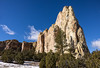
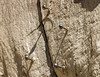
Atsinna Pueblo, the largest of the pueblos in El Morro, dates from about 1275 CE. The community here thrived, as there were reliable resources of food and water found in the valley.
Atsinna Pueblo:
The ancestral Puebloans made use of what they had around them: flat sedimentary rock easily cut up as slabs they could pile one on top of another and cement with clay and pebbles. The pueblo measures about 200’ by 300’ and would have housed between 500 and 600 people at its peak. Approximately 355 interconnected rooms surround an open courtyard. Square and circular ceremonial rooms--underground chambers known as kivas--were spaces for informal gatherings as well as their religious ceremonies.
The archeological excavations in the 1950s exposed adobe walls painted with murals. The dwelling would have a covered roof with an entrance leading into the living areas.
Today, members of the Historic Preservation Division care for Atsinna Pueblo. Careful repairs and upkeep allow visitors to learn about the original inhabitants of El Morro National Monument.
The Use of the Landscape:
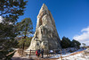
The landscape around Atsinna would have been utilized by the ancestral Puebloans. Naturally occurring pools on the sandstone, called tinajas would have been used for seasonal water sources. Some may have been expanded to collect more water.
In addition, hand-and-toe holds lead into the box canyon as well as near the pool, indicating the water source seen today along the Inscription Loop Trail would have been used during the Pueblo occupation. Source: National Park Service (see below link).
Further reading and information:
Wikipedia
en.wikipedia.org/wiki/El_Morro_National_Monument<2>
National Park Service - El Morro National Monument / Atsinna Pueblo
http://www.nps.gov/elmo/learn/historyculture/atsinna.htm<4>
Directions:
From Mountain View, NM via Indian Service Rte 125 / Ramah Business Route and NM-53 E, 8.6 mi.
You may be viewing yesterday's version of this page. To see the most up to date information please register for a free account.
")
Do not use the above information on other web sites or publications without permission of the contributor.
Nearby Images from Flickr

The above images may not be of the site on this page, but were taken nearby. They are loaded from Flickr so please click on them for image credits.
Click here to see more info for this site
Nearby sites
Click here to view sites on an interactive map of the areaKey: Red: member's photo, Blue: 3rd party photo, Yellow: other image, Green: no photo - please go there and take one, Grey: site destroyed
Download sites to:
KML (Google Earth)
GPX (GPS waypoints)
CSV (Garmin/Navman)
CSV (Excel)
To unlock full downloads you need to sign up as a Contributory Member. Otherwise downloads are limited to 50 sites.
Turn off the page maps and other distractions
Nearby sites listing. In the following links * = Image available
51.0km NNE 32° Casamero* Ancient Village or Settlement
54.5km NE 35° Blue J Ancient Village or Settlement
58.7km WSW 259° Hawikku* Ancient Village or Settlement
72.2km ESE 102° Acoma Pueblo Ancient Village or Settlement
74.2km NNE 17° Kin Ya'a* Ancient Village or Settlement
109.0km N 10° Kin Bineola* Ancient Village or Settlement
109.2km WSW 237° Table Rock Pueblo* Ancient Village or Settlement
113.0km NNE 13° Chaco Culture NHP - Kin Klizhin* Ancient Village or Settlement
116.2km NNE 20° Chaco Culture NHP- Fajada Butte* Rock Art
116.6km NNE 18° Chaco Culture NHP - Tsin Kletzin* Ancient Village or Settlement
117.7km NNE 20° Chaco Culture NHP - Una Vida* Ancient Village or Settlement
117.8km NNE 20° Chaco Culture NHP - Una Vida Petroglyph site* Rock Art
118.3km NNE 22° Chaco Culture NHP - Wijiji Ancient Village or Settlement
118.5km NNE 17° Chaco Culture NHP - Casa Rinconada* Ancient Temple
118.9km NNE 19° Chaco Culture NHP - Hungo Pavi* Ancient Village or Settlement
119.0km NNE 17° Chaco Culture NHP - Pueblo del Arroyo* Ancient Village or Settlement
119.1km NNE 17° Chaco Culture NHP - Pueblo Bonito* Ancient Village or Settlement
119.3km NNE 18° Chaco Culture NHP - Chetro Ketl* Ancient Village or Settlement
119.3km NNE 17° Chaco Culture NHP - Kin Kletso* Ancient Village or Settlement
120.1km NNE 16° Chaco Culture NHP - Penasco Blanco Trail Petroglyphs* Rock Art
120.1km NNE 17° Chaco Culture NHP - New Alto* Ancient Village or Settlement
120.1km NNE 21° Chaco Culture NHP* Ancient Village or Settlement
120.2km NNE 17° Chaco Culture NHP - Pueblo Alto* Ancient Village or Settlement
120.3km NNE 15° Chaco Culture NHP - Peñasco Blanco* Ancient Village or Settlement
120.5km NNE 15° Chaco Culture NHP - Supernova pictograph* Rock Art
View more nearby sites and additional images


 We would like to know more about this location. Please feel free to add a brief description and any relevant information in your own language.
 Wir möchten mehr über diese Stätte erfahren. Bitte zögern Sie nicht, eine kurze Beschreibung und relevante Informationen in Deutsch hinzuzufügen.
 Nous aimerions en savoir encore un peu sur les lieux. S'il vous plaît n'hesitez pas à ajouter une courte description et tous les renseignements pertinents dans votre propre langue.
 Quisieramos informarnos un poco más de las lugares. No dude en añadir una breve descripción y otros datos relevantes en su propio idioma.