<< Other Photo Pages >> Casamero - Ancient Village or Settlement in United States in The Southwest
Submitted by bat400 on Tuesday, 08 April 2014 Page Views: 2336
Multi-periodSite Name: CasameroCountry: United States
NOTE: This site is 15.423 km away from the location you searched for.
Region: The Southwest Type: Ancient Village or Settlement
Nearest Village: Prewitt, New Mexico
Latitude: 35.426000N Longitude: 108.054W
Condition:
| 5 | Perfect |
| 4 | Almost Perfect |
| 3 | Reasonable but with some damage |
| 2 | Ruined but still recognisable as an ancient site |
| 1 | Pretty much destroyed, possibly visible as crop marks |
| 0 | No data. |
| -1 | Completely destroyed |
| 5 | Superb |
| 4 | Good |
| 3 | Ordinary |
| 2 | Not Good |
| 1 | Awful |
| 0 | No data. |
| 5 | Can be driven to, probably with disabled access |
| 4 | Short walk on a footpath |
| 3 | Requiring a bit more of a walk |
| 2 | A long walk |
| 1 | In the middle of nowhere, a nightmare to find |
| 0 | No data. |
| 5 | co-ordinates taken by GPS or official recorded co-ordinates |
| 4 | co-ordinates scaled from a detailed map |
| 3 | co-ordinates scaled from a bad map |
| 2 | co-ordinates of the nearest village |
| 1 | co-ordinates of the nearest town |
| 0 | no data |
Internal Links:
External Links:
")
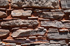
Chaco outlier settlement occupied between 1000AD and 1125 AD. The pueblo had 22 ground floor rooms.
Casamero was excavated between 1966 and 1967 and has since been stabilized so that the Chacoan masonry and the site layout are visible to the public.
On Federal land aprx. 4 mile north of main road I-40. Small parking area. Signposted.
Bureau of Land Managementwebsite.
You may be viewing yesterday's version of this page. To see the most up to date information please register for a free account.
")
Do not use the above information on other web sites or publications without permission of the contributor.
Nearby Images from Flickr


The above images may not be of the site on this page, but were taken nearby. They are loaded from Flickr so please click on them for image credits.
Click here to see more info for this site
Nearby sites
Click here to view sites on an interactive map of the areaKey: Red: member's photo, Blue: 3rd party photo, Yellow: other image, Green: no photo - please go there and take one, Grey: site destroyed
Download sites to:
KML (Google Earth)
GPX (GPS waypoints)
CSV (Garmin/Navman)
CSV (Excel)
To unlock full downloads you need to sign up as a Contributory Member. Otherwise downloads are limited to 50 sites.
Turn off the page maps and other distractions
Nearby sites listing. In the following links * = Image available
4.3km ENE 69° Blue J Ancient Village or Settlement
28.3km N 349° Kin Ya'a* Ancient Village or Settlement
51.0km SSW 212° Atsinna Pueblo* Ancient Village or Settlement
64.7km N 353° Kin Bineola* Ancient Village or Settlement
67.1km N 359° Chaco Culture NHP - Kin Klizhin* Ancient Village or Settlement
67.2km N 11° Chaco Culture NHP- Fajada Butte* Rock Art
68.4km N 7° Chaco Culture NHP - Tsin Kletzin* Ancient Village or Settlement
68.8km N 11° Chaco Culture NHP - Una Vida* Ancient Village or Settlement
68.8km NNE 14° Chaco Culture NHP - Wijiji Ancient Village or Settlement
68.9km N 11° Chaco Culture NHP - Una Vida Petroglyph site* Rock Art
70.2km NNE 29° Pueblo Pintado* Ancient Village or Settlement
70.3km N 9° Chaco Culture NHP - Hungo Pavi* Ancient Village or Settlement
70.4km N 7° Chaco Culture NHP - Casa Rinconada* Ancient Temple
70.8km NNE 13° Chaco Culture NHP* Ancient Village or Settlement
71.1km N 7° Chaco Culture NHP - Pueblo Bonito* Ancient Village or Settlement
71.1km N 6° Chaco Culture NHP - Pueblo del Arroyo* Ancient Village or Settlement
71.1km N 7° Chaco Culture NHP - Chetro Ketl* Ancient Village or Settlement
71.5km N 6° Chaco Culture NHP - Kin Kletso* Ancient Village or Settlement
72.1km N 7° Chaco Culture NHP - New Alto* Ancient Village or Settlement
72.1km N 7° Chaco Culture NHP - Pueblo Alto* Ancient Village or Settlement
72.6km N 5° Chaco Culture NHP - Penasco Blanco Trail Petroglyphs* Rock Art
73.0km SE 144° Acoma Pueblo Ancient Village or Settlement
73.0km N 4° Chaco Culture NHP - Peñasco Blanco* Ancient Village or Settlement
73.2km N 4° Chaco Culture NHP - Supernova pictograph* Rock Art
100.8km WSW 237° Hawikku* Ancient Village or Settlement
View more nearby sites and additional images


 We would like to know more about this location. Please feel free to add a brief description and any relevant information in your own language.
 Wir möchten mehr über diese Stätte erfahren. Bitte zögern Sie nicht, eine kurze Beschreibung und relevante Informationen in Deutsch hinzuzufügen.
 Nous aimerions en savoir encore un peu sur les lieux. S'il vous plaît n'hesitez pas à ajouter une courte description et tous les renseignements pertinents dans votre propre langue.
 Quisieramos informarnos un poco más de las lugares. No dude en añadir una breve descripción y otros datos relevantes en su propio idioma.