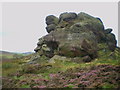
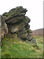
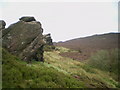
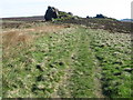
<< Our Photo Pages >> The Bald Stone - Natural Stone / Erratic / Other Natural Feature in England in Staffordshire
Submitted by TimPrevett on Thursday, 05 April 2007 Page Views: 6923
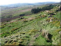
Natural PlacesSite Name: The Bald StoneCountry: England
NOTE: This site is 1.091 km away from the location you searched for.
County: Staffordshire Type: Natural Stone / Erratic / Other Natural Feature
Nearest Town: Leek Nearest Village: Upper Hulme
Map Ref: SK018641
Latitude: 53.174006N Longitude: 1.974527W
Condition:
| 5 | Perfect |
| 4 | Almost Perfect |
| 3 | Reasonable but with some damage |
| 2 | Ruined but still recognisable as an ancient site |
| 1 | Pretty much destroyed, possibly visible as crop marks |
| 0 | No data. |
| -1 | Completely destroyed |
| 5 | Superb |
| 4 | Good |
| 3 | Ordinary |
| 2 | Not Good |
| 1 | Awful |
| 0 | No data. |
| 5 | Can be driven to, probably with disabled access |
| 4 | Short walk on a footpath |
| 3 | Requiring a bit more of a walk |
| 2 | A long walk |
| 1 | In the middle of nowhere, a nightmare to find |
| 0 | No data. |
| 5 | co-ordinates taken by GPS or official recorded co-ordinates |
| 4 | co-ordinates scaled from a detailed map |
| 3 | co-ordinates scaled from a bad map |
| 2 | co-ordinates of the nearest village |
| 1 | co-ordinates of the nearest town |
| 0 | no data |
Internal Links:
External Links:
I have visited· I would like to visit
commando would like to visit
Conroy visited on 11th Feb 2011 - their rating: Cond: 5 Amb: 4 Access: 4
TimPrevett have visited here
")
You may be viewing yesterday's version of this page. To see the most up to date information please register for a free account.
Do not use the above information on other web sites or publications without permission of the contributor.
Nearby Images from Geograph Britain and Ireland:
©2009(licence)
©2009(licence)
©2009(licence)
©2009(licence)
©2009(licence)
The above images may not be of the site on this page, they are loaded from Geograph.
Please Submit an Image of this site or go out and take one for us!
Click here to see more info for this site
Nearby sites
Key: Red: member's photo, Blue: 3rd party photo, Yellow: other image, Green: no photo - please go there and take one, Grey: site destroyed
Download sites to:
KML (Google Earth)
GPX (GPS waypoints)
CSV (Garmin/Navman)
CSV (Excel)
To unlock full downloads you need to sign up as a Contributory Member. Otherwise downloads are limited to 50 sites.
Turn off the page maps and other distractions
Nearby sites listing. In the following links * = Image available
1.7km W 263° The Roaches Barrow Round Barrow(s) (SK001639)
1.8km S 173° The Winking Man* Natural Stone / Erratic / Other Natural Feature (SK0202162362)
1.8km WSW 253° Sainter's Dolmen* Rock Outcrop (SK00106357)
2.3km SSW 205° Bawd Stone* Natural Stone / Erratic / Other Natural Feature (SK0079561976)
2.4km SSW 204° Sainter's Circle* Stone Circle (SK008619)
2.6km SSW 208° The Roaches* Natural Stone / Erratic / Other Natural Feature (SK006618)
2.9km NW 323° Roaches Stone carving* Carving (SK00076637)
2.9km N 4° Flash Chambered Tomb (SK0267)
3.4km WNW 296° Lud's Church* Natural Stone / Erratic / Other Natural Feature (SJ987656)
3.9km SE 144° Merryton Low 1* Round Barrow(s) (SK041610)
4.0km SSW 202° Leekfrith Tumulus* Round Barrow(s) (SK003604)
4.0km SSE 147° Merryton Low 2* Round Barrow(s) (SK040607)
4.1km SSW 206° Leekfrith Stone* Standing Stone (Menhir) (SK000604)
5.0km ENE 64° Coatestown Barrow Round Barrow(s) (SK063663)
5.3km NE 36° Brand End standing stones* Standing Stones (SK0488868373)
5.4km WNW 296° Allgreave* Standing Stone (Menhir) (SJ969665)
5.6km WNW 286° Bartomley Farm* Long Barrow (SJ964656)
5.7km NE 48° Hollins Hill* Cairn (SK060679)
5.7km WSW 239° Gun Hill Standing Stone* Standing Stone (Menhir) (SJ969612)
5.7km S 175° Thorncliffe Barrow Round Barrow(s) (SK023584)
6.1km NE 45° Stoup High Edge* Cairn (SK061684)
6.3km N 8° Dane Head* Marker Stone (SK02657036)
6.4km SSW 212° Nine Pins* Stone Circle (SJ984587)
6.4km W 259° Heaton Low* Round Barrow(s) (SJ955629)
6.5km NE 35° The Frith* Round Barrow(s) (SK055694)
View more nearby sites and additional images


 We would like to know more about this location. Please feel free to add a brief description and any relevant information in your own language.
 Wir möchten mehr über diese Stätte erfahren. Bitte zögern Sie nicht, eine kurze Beschreibung und relevante Informationen in Deutsch hinzuzufügen.
 Nous aimerions en savoir encore un peu sur les lieux. S'il vous plaît n'hesitez pas à ajouter une courte description et tous les renseignements pertinents dans votre propre langue.
 Quisieramos informarnos un poco más de las lugares. No dude en añadir una breve descripción y otros datos relevantes en su propio idioma.