


<< Our Photo Pages >> Ranbury Ring - Hillfort in England in Gloucestershire
Submitted by 4clydesdale7 on Friday, 15 July 2011 Page Views: 8267
Iron Age and Later PrehistorySite Name: Ranbury RingCountry: England
NOTE: This site is 2.564 km away from the location you searched for.
County: Gloucestershire Type: Hillfort
Nearest Village: Ampney St Peter
Map Ref: SP090009
Latitude: 51.706767N Longitude: 1.871154W
Condition:
| 5 | Perfect |
| 4 | Almost Perfect |
| 3 | Reasonable but with some damage |
| 2 | Ruined but still recognisable as an ancient site |
| 1 | Pretty much destroyed, possibly visible as crop marks |
| 0 | No data. |
| -1 | Completely destroyed |
| 5 | Superb |
| 4 | Good |
| 3 | Ordinary |
| 2 | Not Good |
| 1 | Awful |
| 0 | No data. |
| 5 | Can be driven to, probably with disabled access |
| 4 | Short walk on a footpath |
| 3 | Requiring a bit more of a walk |
| 2 | A long walk |
| 1 | In the middle of nowhere, a nightmare to find |
| 0 | No data. |
| 5 | co-ordinates taken by GPS or official recorded co-ordinates |
| 4 | co-ordinates scaled from a detailed map |
| 3 | co-ordinates scaled from a bad map |
| 2 | co-ordinates of the nearest village |
| 1 | co-ordinates of the nearest town |
| 0 | no data |
Internal Links:
External Links:
I have visited· I would like to visit
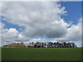
4clydesdale7 visited on 14th Jul 2011 - their rating: Cond: 3 Amb: 4 Access: 3 A pleasant walk around the fort - much to see
")
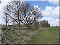
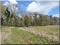
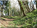
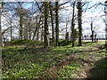
On the NW side much of the ditch has been infilled - in places there is also a small outer ditch - it reputedly has not been excavated - the fortifications enclose an area of roughly 11.5 acres - certainly well worth a visit and relatively easy to walk to and round
Read More at PastScape.
You may be viewing yesterday's version of this page. To see the most up to date information please register for a free account.
")
")
")
Do not use the above information on other web sites or publications without permission of the contributor.
Nearby Images from Geograph Britain and Ireland:
©2016(licence)
©2016(licence)
©2016(licence)
©2016(licence)
©2016(licence)
The above images may not be of the site on this page, they are loaded from Geograph.
Please Submit an Image of this site or go out and take one for us!
Click here to see more info for this site
Nearby sites
Key: Red: member's photo, Blue: 3rd party photo, Yellow: other image, Green: no photo - please go there and take one, Grey: site destroyed
Download sites to:
KML (Google Earth)
GPX (GPS waypoints)
CSV (Garmin/Navman)
CSV (Excel)
To unlock full downloads you need to sign up as a Contributory Member. Otherwise downloads are limited to 50 sites.
Turn off the page maps and other distractions
Nearby sites listing. In the following links * = Image available
6.1km WNW 286° Tar Barrow* Round Barrow(s) (SP03110252)
6.7km NNE 13° Ablington Camp* Hillfort (SP105074)
7.0km W 280° Corinium Museum* Museum (SP0212602059)
7.0km W 275° Querns Barrow* Chambered Tomb (SP01980150)
7.8km NNW 344° Colnpen* Chambered Tomb (SP068084)
7.8km ENE 65° Barrow Elm* Round Barrow(s) (SP16110420)
8.6km NNE 13° Ablington Long Barrow Chambered Tomb (SP10910925)
8.6km NNE 17° Saltway Barn Chambered Cairn (SP115091)
8.7km NNE 12° Lamborough Banks* Chambered Cairn (SP10760942)
8.9km NNW 330° Calmsden spring* Holy Well or Sacred Spring (SP04540863)
9.0km NW 308° Bagendon* Hillfort (SP018064)
9.7km WNW 288° Wellhill Copse Barrow* Round Barrow(s) (SO99740387)
9.7km NW 313° North Cerney 1* Chambered Tomb (SP01840752)
10.3km WSW 256° Lyd Well (Kemble) Holy Well or Sacred Spring (ST98969847)
10.3km S 183° Salt's Hole* Holy Well or Sacred Spring (SU084906)
10.6km W 260° King Athelstans Mounting Stone* Marker Stone (ST98549899)
10.7km NNW 335° Pinkwell (Chedworth)* Chambered Cairn (SP04531058)
10.8km NE 44° Ladborough Camp* Hillfort (SP16540870)
10.9km W 264° Trewsbury Camp* Hillfort (ST98109980)
11.0km N 6° Crickley Barrow Chambered Tomb (SP101118)
11.1km NW 312° North Cerney Cursus Cursus (SP00800834)
11.3km SSW 197° Bury Hill Camp (Purton)* Hillfort (SU05759010)
11.6km N 349° Woodbarrow (Glos)* Chambered Tomb (SP06731228)
11.6km NE 41° Lad Barrow* Chambered Tomb (SP166097)
11.7km NW 315° North Cerney 2* Round Barrow(s) (SP00790919)
View more nearby sites and additional images


 We would like to know more about this location. Please feel free to add a brief description and any relevant information in your own language.
 Wir möchten mehr über diese Stätte erfahren. Bitte zögern Sie nicht, eine kurze Beschreibung und relevante Informationen in Deutsch hinzuzufügen.
 Nous aimerions en savoir encore un peu sur les lieux. S'il vous plaît n'hesitez pas à ajouter une courte description et tous les renseignements pertinents dans votre propre langue.
 Quisieramos informarnos un poco más de las lugares. No dude en añadir una breve descripción y otros datos relevantes en su propio idioma.