<< Text Pages >> Morwick 2e & 2g - Rock Art in England in Northumberland
Submitted by Anne T on Thursday, 29 March 2018 Page Views: 418
Rock ArtSite Name: Morwick 2e & 2g Alternative Name: ERA-615; Beckensall 775; ERA-617; Beckensall 777; NRM 8059; SAM 24698; SMR/HER N5558Country: England
NOTE: This site is 2.224 km away from the location you searched for.
County: Northumberland Type: Rock Art
Nearest Town: Alnwick Nearest Village: Warkworth
Map Ref: NU2328004415
Latitude: 55.333240N Longitude: 1.634581W
Condition:
| 5 | Perfect |
| 4 | Almost Perfect |
| 3 | Reasonable but with some damage |
| 2 | Ruined but still recognisable as an ancient site |
| 1 | Pretty much destroyed, possibly visible as crop marks |
| 0 | No data. |
| -1 | Completely destroyed |
| 5 | Superb |
| 4 | Good |
| 3 | Ordinary |
| 2 | Not Good |
| 1 | Awful |
| 0 | No data. |
| 5 | Can be driven to, probably with disabled access |
| 4 | Short walk on a footpath |
| 3 | Requiring a bit more of a walk |
| 2 | A long walk |
| 1 | In the middle of nowhere, a nightmare to find |
| 0 | No data. |
| 5 | co-ordinates taken by GPS or official recorded co-ordinates |
| 4 | co-ordinates scaled from a detailed map |
| 3 | co-ordinates scaled from a bad map |
| 2 | co-ordinates of the nearest village |
| 1 | co-ordinates of the nearest town |
| 0 | no data |
Be the first person to rate this site - see the 'Contribute!' box in the right hand menu.
Internal Links:
External Links:
Rock Art in Northumberland
Two rock art panels are recorded at the same grid reference:
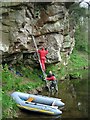
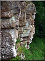
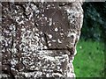
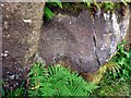
Morwick 2e: This rock art panel is recorded by NADRAP as being on a large slab of cliff face set back from the river on an upper ledge which is described as precarious. The panel has "five cups of uniform size and almost certainly artificial." Beckensall had previously recorded seven cup marks pecked on a near-vertical surface.
For more information see England's Rock Art entry for ERA-615 Morwick 2e, which includes both NADRAP's and Beckensall's descriptions, Beckensall's Archive notes, photographs, a sketch of the rock and its motifs, and media from the Beckensall Archive.
The original Beckensall record can be found at Internet Archive: Beckensall 775 Morwick 2e.
Morwick 2g: This rock art panel is recorded by NADRAP as having possible highly eroded rings around a cup on the left hand side of the panel and another to its left. There is a possible double spiral on its right hand side across an horizontal crack and above the same crack to the left, two possible ringed motifs. Beckensall recorded "two concentric rings, a cup and arc, two cups linked by a groove, and six cups."
For more information see England's Rock Art entry for ERA-617 Morwick 2g, which includes both NADRAP's and Beckensall's descriptions, Beckensall's Archive notes, a sketch of the rock and its motifs, and media from the Beckensall Archive.
The original Beckensall record can be found at Internet Archive: Beckensall 777 Morwick 2g.
These rock art panels are located on Open Access land [note: Beckensall recorded 'Access by Right of Way'].
Note: Have you seen this rock art panel? Do you have any photographs or information to add?
You may be viewing yesterday's version of this page. To see the most up to date information please register for a free account.
Do not use the above information on other web sites or publications without permission of the contributor.
Nearby Images from Geograph Britain and Ireland:
©2020(licence)

©2020(licence)
©2011(licence)
©2011(licence)
©2011(licence)
The above images may not be of the site on this page, they are loaded from Geograph.
Please Submit an Image of this site or go out and take one for us!
Click here to see more info for this site
Nearby sites
Key: Red: member's photo, Blue: 3rd party photo, Yellow: other image, Green: no photo - please go there and take one, Grey: site destroyed
Download sites to:
KML (Google Earth)
GPX (GPS waypoints)
CSV (Garmin/Navman)
CSV (Excel)
To unlock full downloads you need to sign up as a Contributory Member. Otherwise downloads are limited to 50 sites.
Turn off the page maps and other distractions
Nearby sites listing. In the following links * = Image available
1m SSW 206° Morwick 2f* Rock Art (NU2328004414)
6m E 90° Morwick 2b & 2c* Rock Art (NU2328604415)
6m E 81° Morwick 2a* Rock Art (NU2328604416)
6m ENE 72° Morwick 2d* Rock Art (NU2328604417)
20m E 82° Morwick 1f* Rock Art (NU2330004418)
20m E 79° Morwick N01 Rock Art (NU2330004419)
21m ENE 76° Morwick 1d & 1e* Rock Art (NU2330004420)
24m E 81° Morwick 1g Rock Art (NU2330404419)
26m E 79° Morwick 1c Rock Art (NU2330604420)
27m ENE 73° Morwick* Rock Art (NU2330604423)
28m E 82° Morwick 1b* Rock Art (NU2330804419)
28m E 80° Morwick 1a* Rock Art (NU2330804420)
4.0km E 84° Amble Pier Cist* Cist (NU27280484)
4.4km E 92° Amble Quarry Cists* Cist (NU277043)
5.7km ESE 117° Low Hauxley* Cairn (NU284018)
6.7km NNE 14° Alnmouth Wall Rock 33 Rock Art (NU2485610982)
6.8km NNE 14° Alnmouth Wall Rock 32* Rock Art (NU2485610992)
6.8km NNE 14° Alnmouth Wall Rock 38* Rock Art (NU2487910987)
6.8km NNE 14° Alnmouth Wall Rock 34* Rock Art (NU2487110990)
6.8km NNE 14° Alnmouth Wall Rock 35* Rock Art (NU2487510991)
6.8km NNE 14° Alnmouth Wall Rock 28 & 29 Rock Art (NU2484210999)
6.8km NNE 14° Alnmouth Wall Rock 37* Rock Art (NU2487610991)
6.8km NNE 13° Alnmouth Wall Rock 8 Rock Art (NU2478311013)
6.8km NNE 14° Alnmouth Wall Rock 36* Rock Art (NU2487410992)
6.8km NNE 14° Alnmouth Wall Rock 30 & 31 Rock Art (NU2484911000)
View more nearby sites and additional images


 We would like to know more about this location. Please feel free to add a brief description and any relevant information in your own language.
 Wir möchten mehr über diese Stätte erfahren. Bitte zögern Sie nicht, eine kurze Beschreibung und relevante Informationen in Deutsch hinzuzufügen.
 Nous aimerions en savoir encore un peu sur les lieux. S'il vous plaît n'hesitez pas à ajouter une courte description et tous les renseignements pertinents dans votre propre langue.
 Quisieramos informarnos un poco más de las lugares. No dude en añadir una breve descripción y otros datos relevantes en su propio idioma.