<< Our Photo Pages >> Wappenbury - Hillfort in England in Warwickshire
Submitted by gautrek on Sunday, 15 October 2006 Page Views: 11394
Iron Age and Later PrehistorySite Name: WappenburyCountry: England County: Warwickshire Type: Hillfort
Nearest Town: Leaminton Spa Nearest Village: Wappenbury
Map Ref: SP377693
Latitude: 52.320513N Longitude: 1.44832W
Condition:
| 5 | Perfect |
| 4 | Almost Perfect |
| 3 | Reasonable but with some damage |
| 2 | Ruined but still recognisable as an ancient site |
| 1 | Pretty much destroyed, possibly visible as crop marks |
| 0 | No data. |
| -1 | Completely destroyed |
| 5 | Superb |
| 4 | Good |
| 3 | Ordinary |
| 2 | Not Good |
| 1 | Awful |
| 0 | No data. |
| 5 | Can be driven to, probably with disabled access |
| 4 | Short walk on a footpath |
| 3 | Requiring a bit more of a walk |
| 2 | A long walk |
| 1 | In the middle of nowhere, a nightmare to find |
| 0 | No data. |
| 5 | co-ordinates taken by GPS or official recorded co-ordinates |
| 4 | co-ordinates scaled from a detailed map |
| 3 | co-ordinates scaled from a bad map |
| 2 | co-ordinates of the nearest village |
| 1 | co-ordinates of the nearest town |
| 0 | no data |
Internal Links:
External Links:
")
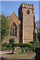
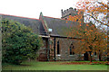
It also has a very nice church in the centre of the village.
You may be viewing yesterday's version of this page. To see the most up to date information please register for a free account.
")
")
")
Do not use the above information on other web sites or publications without permission of the contributor.
Nearby Images from Geograph Britain and Ireland:
©2014(licence)
©2014(licence)
©2011(licence)
©2007(licence)
©2009(licence)
The above images may not be of the site on this page, they are loaded from Geograph.
Please Submit an Image of this site or go out and take one for us!
Click here to see more info for this site
Nearby sites
Key: Red: member's photo, Blue: 3rd party photo, Yellow: other image, Green: no photo - please go there and take one, Grey: site destroyed
Download sites to:
KML (Google Earth)
GPX (GPS waypoints)
CSV (Garmin/Navman)
CSV (Excel)
To unlock full downloads you need to sign up as a Contributory Member. Otherwise downloads are limited to 50 sites.
Turn off the page maps and other distractions
Nearby sites listing. In the following links * = Image available
5.2km NNE 33° Knightlow barrow* Round Barrow(s) (SP405737)
5.8km NNE 28° Ryton on Dunsmore Cursus Cursus (SP404744)
8.8km SSE 153° Holy Well (Southam)* Holy Well or Sacred Spring (SP417615)
11.1km SW 233° Barford Cursus Cursus (SP289625)
11.3km SW 232° Barford Cursus Cursus (SP288623)
11.6km NNW 333° St. Catherine's Well (Coventry) Holy Well or Sacred Spring (SP323796)
12.0km NNE 31° Brinklow Tumulus* Artificial Mound (SP43877957)
12.3km SW 215° Oakley Wood Fort* Hillfort (SP306592)
13.0km WSW 237° Longbridge Cursus Cursus (SP269621)
13.0km SW 235° Warwick Cursus Cursus (SP27066176)
13.1km W 274° Beausale Fort* Hillfort (SP246702)
13.1km SW 236° Longbridge Cursus Cursus (SP269618)
13.5km WNW 283° St. John's Well (Warwickshire)* Holy Well or Sacred Spring (SP24487234)
13.8km ENE 67° The Island (Rugby School)* Round Barrow(s) (SP50367477)
15.5km SW 226° Wasperton Timber Circle (SP265585)
15.7km SW 224° Charlecote A Cursus Cursus (SP26895795)
16.3km ESE 101° Holy Well, Braunston* Holy Well or Sacred Spring (SP537662)
16.5km NW 307° Berkswell* Holy Well or Sacred Spring (SP244791)
16.7km S 179° Burton Dassett Tumuli Round Barrow(s) (SP380526)
16.8km SW 221° Charlecote B Cursus Cursus (SP268565)
16.9km SW 220° Charlecote B Cursus Cursus (SP268563)
17.0km NE 54° Churchover Bowl Barrow* Round Barrow(s) (SP51457929)
17.3km NNW 336° Burrow Hill Camp (Warwickshire)* Hillfort (SP304850)
17.7km SW 226° Hampton Lucy A Timber Circle (SP251568)
17.7km SW 225° Hampton Lucy B Timber Circle (SP252567)
View more nearby sites and additional images


 We would like to know more about this location. Please feel free to add a brief description and any relevant information in your own language.
 Wir möchten mehr über diese Stätte erfahren. Bitte zögern Sie nicht, eine kurze Beschreibung und relevante Informationen in Deutsch hinzuzufügen.
 Nous aimerions en savoir encore un peu sur les lieux. S'il vous plaît n'hesitez pas à ajouter une courte description et tous les renseignements pertinents dans votre propre langue.
 Quisieramos informarnos un poco más de las lugares. No dude en añadir una breve descripción y otros datos relevantes en su propio idioma.