

<< Our Photo Pages >> Staunton Harold's ancient village - Ancient Village or Settlement in England in Leicestershire and Rutland
Submitted by ESgt on Monday, 20 July 2015 Page Views: 3018
Multi-periodSite Name: Staunton Harold's ancient villageCountry: England
NOTE: This site is 1.583 km away from the location you searched for.
County: Leicestershire and Rutland Type: Ancient Village or Settlement
Nearest Town: Melbourne Nearest Village: Lount
Map Ref: SK3822120860
Latitude: 52.783971N Longitude: 1.434755W
Condition:
| 5 | Perfect |
| 4 | Almost Perfect |
| 3 | Reasonable but with some damage |
| 2 | Ruined but still recognisable as an ancient site |
| 1 | Pretty much destroyed, possibly visible as crop marks |
| 0 | No data. |
| -1 | Completely destroyed |
| 5 | Superb |
| 4 | Good |
| 3 | Ordinary |
| 2 | Not Good |
| 1 | Awful |
| 0 | No data. |
| 5 | Can be driven to, probably with disabled access |
| 4 | Short walk on a footpath |
| 3 | Requiring a bit more of a walk |
| 2 | A long walk |
| 1 | In the middle of nowhere, a nightmare to find |
| 0 | No data. |
| 5 | co-ordinates taken by GPS or official recorded co-ordinates |
| 4 | co-ordinates scaled from a detailed map |
| 3 | co-ordinates scaled from a bad map |
| 2 | co-ordinates of the nearest village |
| 1 | co-ordinates of the nearest town |
| 0 | no data |
Internal Links:
External Links:
")
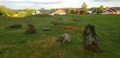
This abandoned village is visible as lumps and bumps in the ground, but with two stone built-over springs, in the grounds of the Staunton Harold Estate. It lies to the south side of the lake, opposite the church.
You may be viewing yesterday's version of this page. To see the most up to date information please register for a free account.
")
")
")
Do not use the above information on other web sites or publications without permission of the contributor.
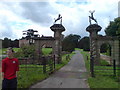
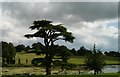
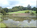
Nearby Images from Geograph Britain and Ireland:
©2007(licence)
©2007(licence)

©2017(licence)

©2008(licence)
©2007(licence)
The above images may not be of the site on this page, they are loaded from Geograph.
Please Submit an Image of this site or go out and take one for us!
Click here to see more info for this site
Nearby sites
Key: Red: member's photo, Blue: 3rd party photo, Yellow: other image, Green: no photo - please go there and take one, Grey: site destroyed
Download sites to:
KML (Google Earth)
GPX (GPS waypoints)
CSV (Garmin/Navman)
CSV (Excel)
To unlock full downloads you need to sign up as a Contributory Member. Otherwise downloads are limited to 50 sites.
Turn off the page maps and other distractions
Nearby sites listing. In the following links * = Image available
1.4km NE 35° Moated Mound at Breedon-on-the-Hill* Artificial Mound (SK3902822009)
3.4km NE 44° St Mary and St Hardulf (Breedon on the Hill)* Ancient Cross (SK4055723335)
3.4km NE 45° The Bulwarks (Breedon on the Hill)* Hillfort (SK406233)
4.0km SE 136° Griffy's Well* Holy Well or Sacred Spring (SK4118)
5.4km N 4° Kings Newton Holy Well* Holy Well or Sacred Spring (SK38572629)
5.7km ESE 117° Grace Dieu Priory Stone* Standing Stone (Menhir) (SK433183)
5.8km WSW 243° Blackfordby Spring* Holy Well or Sacred Spring (SK331182)
6.0km NW 318° Hangman's Stone (Ingleby)* Marker Stone (SK34162524)
6.4km NW 322° Heath Wood, Ingleby* Artificial Mound (SK34222591)
7.0km SE 131° Whitwick Spring* Holy Well or Sacred Spring (SK435163)
7.0km E 98° Belton Banjo enclosure* Causewayed Enclosure (SK45161997)
7.1km NE 44° Castle Donington hilltop mound* Long Barrow (SK432260)
7.3km ESE 121° Swanimote Hill* Natural Stone / Erratic / Other Natural Feature (SK445172)
7.3km WSW 239° Blackfordby Spring* Holy Well or Sacred Spring (SK3217)
7.7km NNW 326° Anchor Church* Cave or Rock Shelter (SK3390827236)
8.1km ESE 120° Altar Stone, Whitwick* Modern Stone Circle etc (SK453168)
8.3km NNE 25° Aston Cursus Cursus (SK416284)
8.4km NNE 25° Aston Cursus Cursus (SK417285)
8.8km N 349° Swarkestone Lows* Barrow Cemetery (SK365295)
8.9km NNW 327° Round Hill Barrow* Round Barrow(s) (SK33342832)
9.8km ESE 120° Hanging Stone (Leicestershire) Natural Stone / Erratic / Other Natural Feature (SK467160)
10.1km NW 309° St Wystan's (Repton)* Early Christian Sculptured Stone (SK30292717)
10.1km NNE 26° Aston Cursus Cursus (SK426300)
10.2km SE 124° Stone nr Oaks in Charnwood* Natural Stone / Erratic / Other Natural Feature (SK46721523)
10.2km NW 322° Findern Cursus Cursus (SK319289)
View more nearby sites and additional images


 We would like to know more about this location. Please feel free to add a brief description and any relevant information in your own language.
 Wir möchten mehr über diese Stätte erfahren. Bitte zögern Sie nicht, eine kurze Beschreibung und relevante Informationen in Deutsch hinzuzufügen.
 Nous aimerions en savoir encore un peu sur les lieux. S'il vous plaît n'hesitez pas à ajouter une courte description et tous les renseignements pertinents dans votre propre langue.
 Quisieramos informarnos un poco más de las lugares. No dude en añadir una breve descripción y otros datos relevantes en su propio idioma.