

<< Our Photo Pages >> Roman Ridge (Rotherham) - Misc. Earthwork in England in Yorkshire (South)
Submitted by Andy B on Wednesday, 09 March 2011 Page Views: 11990
Multi-periodSite Name: Roman Ridge (Rotherham)Country: England County: Yorkshire (South) Type: Misc. Earthwork
Nearest Town: Rotherham
Map Ref: SK40499598
Latitude: 53.459021N Longitude: 1.39166W
Condition:
| 5 | Perfect |
| 4 | Almost Perfect |
| 3 | Reasonable but with some damage |
| 2 | Ruined but still recognisable as an ancient site |
| 1 | Pretty much destroyed, possibly visible as crop marks |
| 0 | No data. |
| -1 | Completely destroyed |
| 5 | Superb |
| 4 | Good |
| 3 | Ordinary |
| 2 | Not Good |
| 1 | Awful |
| 0 | No data. |
| 5 | Can be driven to, probably with disabled access |
| 4 | Short walk on a footpath |
| 3 | Requiring a bit more of a walk |
| 2 | A long walk |
| 1 | In the middle of nowhere, a nightmare to find |
| 0 | No data. |
| 5 | co-ordinates taken by GPS or official recorded co-ordinates |
| 4 | co-ordinates scaled from a detailed map |
| 3 | co-ordinates scaled from a bad map |
| 2 | co-ordinates of the nearest village |
| 1 | co-ordinates of the nearest town |
| 0 | no data |
Internal Links:
External Links:
I have visited· I would like to visit
Andy B MartinRS have visited here
 (PID:74350)")
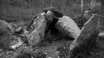
Single lynchet ranging in height from 1.6m to 3.2m, probably exaggerated by plough headland. Beyond SK 398 925 the feature has been destroyed by housing although still visible in places.
Further details at Pastscape, also here, here and here.
Note: Prehistoric earthwork in Rotherham to be rescued from mountain bike damage
You may be viewing yesterday's version of this page. To see the most up to date information please register for a free account.
Do not use the above information on other web sites or publications without permission of the contributor.
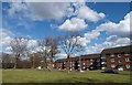
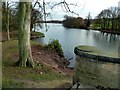
Nearby Images from Geograph Britain and Ireland:
©2010(licence)
©2008(licence)
©2008(licence)
©2008(licence)
©2011(licence)
The above images may not be of the site on this page, they are loaded from Geograph.
Please Submit an Image of this site or go out and take one for us!
Click here to see more info for this site
Nearby sites
Key: Red: member's photo, Blue: 3rd party photo, Yellow: other image, Green: no photo - please go there and take one, Grey: site destroyed
Download sites to:
KML (Google Earth)
GPX (GPS waypoints)
CSV (Garmin/Navman)
CSV (Excel)
To unlock full downloads you need to sign up as a Contributory Member. Otherwise downloads are limited to 50 sites.
Turn off the page maps and other distractions
Nearby sites listing. In the following links * = Image available
1.3km SW 232° Scholes Wood* Hillfort (SK395952)
3.5km W 271° St. Helen's Well (Thorpe Hesley) Holy Well or Sacred Spring (SK370960)
5.5km WSW 251° Ecclesfield* Ancient Cross (SK353941)
5.7km SSW 209° Wincobank* Vitrified Fort (SK378910)
7.1km W 274° Robin Hood Well (Yorkshire South)* Holy Well or Sacred Spring (SK334964)
7.8km SSW 201° Darnall Common* Modern Stone Circle etc (SK378887)
9.5km W 271° Burnt Hill Plantation* Rock Art (SK310960)
10.0km W 271° Dragon Well (Wharncliffe) Holy Well or Sacred Spring (SK305961)
10.7km WSW 240° Wadsley Common* Stone Circle (SK312906)
10.9km SW 218° Weston Park Museum* Museum (SK3389487292)
11.0km ENE 76° St Francis's Well (Conisborough) Holy Well or Sacred Spring (SK51179881)
11.0km ENE 76° St Peter's Minster (Conisbrough)* Sculptured Stone (SK512988)
11.1km NW 325° Worsborough Common Hillfort (SE340050)
11.4km NW 309° Stainborough Castle* Hillfort (SE315030)
11.6km W 281° Deepcar Mesolithic Settlement* Ancient Village or Settlement (SK291981)
11.6km ENE 72° Cadeby Henge Henge (SK515997)
12.2km W 275° Dragon's Well (Bolsterstone) Holy Well or Sacred Spring (SK28279697)
12.4km S 179° Birley Spa Holy Well or Sacred Spring (SK40908361)
13.6km ENE 64° Scabba Wood Rock Shelter Cave or Rock Shelter (SE527020)
14.2km WSW 256° St Nicholas (Bradfield) Ancient Cross (SK26729254)
14.2km N 9° Ringstone Hill (Brierley) Stone Circle (SE42571005)
14.5km E 79° Edlington Woods* Cave or Rock Shelter (SK548988)
14.6km W 263° Handsome Cross Ancient Cross (SK26019412)
14.8km NNE 12° South Kirby Camp* Hillfort (SE435105)
15.1km SSW 212° Ecclesall Woods* Rock Art (SK326831)
View more nearby sites and additional images


 We would like to know more about this location. Please feel free to add a brief description and any relevant information in your own language.
 Wir möchten mehr über diese Stätte erfahren. Bitte zögern Sie nicht, eine kurze Beschreibung und relevante Informationen in Deutsch hinzuzufügen.
 Nous aimerions en savoir encore un peu sur les lieux. S'il vous plaît n'hesitez pas à ajouter une courte description et tous les renseignements pertinents dans votre propre langue.
 Quisieramos informarnos un poco más de las lugares. No dude en añadir una breve descripción y otros datos relevantes en su propio idioma.