<< Text Pages >> St Francis's Well (Conisborough) - Holy Well or Sacred Spring in England in Yorkshire (South)
Submitted by Anne T on Monday, 08 January 2018 Page Views: 1656
Springs and Holy WellsSite Name: St Francis''s Well (Conisborough) Alternative Name: Town Well (Conisborough)Country: England
NOTE: This site is 4.425 km away from the location you searched for.
County: Yorkshire (South) Type: Holy Well or Sacred Spring
Nearest Town: Conisborough
Map Ref: SK51179881
Latitude: 53.483529N Longitude: 1.230367W
Condition:
| 5 | Perfect |
| 4 | Almost Perfect |
| 3 | Reasonable but with some damage |
| 2 | Ruined but still recognisable as an ancient site |
| 1 | Pretty much destroyed, possibly visible as crop marks |
| 0 | No data. |
| -1 | Completely destroyed |
| 5 | Superb |
| 4 | Good |
| 3 | Ordinary |
| 2 | Not Good |
| 1 | Awful |
| 0 | No data. |
| 5 | Can be driven to, probably with disabled access |
| 4 | Short walk on a footpath |
| 3 | Requiring a bit more of a walk |
| 2 | A long walk |
| 1 | In the middle of nowhere, a nightmare to find |
| 0 | No data. |
| 5 | co-ordinates taken by GPS or official recorded co-ordinates |
| 4 | co-ordinates scaled from a detailed map |
| 3 | co-ordinates scaled from a bad map |
| 2 | co-ordinates of the nearest village |
| 1 | co-ordinates of the nearest town |
| 0 | no data |
Be the first person to rate this site - see the 'Contribute!' box in the right hand menu.
Internal Links:
External Links:
Holy Well or Sacred Spring in Yorkshire (South)
The Northern Antiquarian (TNA) features a page for this holy well - see their entry for St Francis’ Well, Conisborough, South Yorkshire, which gives directions for finding this well together with a description and local folklore.
The well is also recorded as Pastscape Monument No. 318750. A 1918 reference says: "he town well at Conisborough is covered by a building very mediaeval-looking. In time of drought a saint named Francis is said to have struck the rock with his rod and water gushed out", adding from 1953 a report which says: "This well is covered by a rectangular stone building 2.6 m. long x 2.0 m. wide x 3.0 m. high. A small square window [?] on the SW side has been bricked up. Date of well and date of erection of building not ascertained during field investigation."
Note: Have you visited this site? Do you have any information or photographs to add?
You may be viewing yesterday's version of this page. To see the most up to date information please register for a free account.
Do not use the above information on other web sites or publications without permission of the contributor.
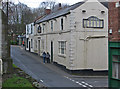
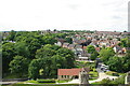
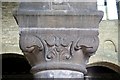
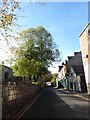
Nearby Images from Geograph Britain and Ireland:
©2014(licence)
©2023(licence)
©2008(licence)
©2018(licence)
©2018(licence)
The above images may not be of the site on this page, they are loaded from Geograph.
Please Submit an Image of this site or go out and take one for us!
Click here to see more info for this site
Nearby sites
Key: Red: member's photo, Blue: 3rd party photo, Yellow: other image, Green: no photo - please go there and take one, Grey: site destroyed
Download sites to:
KML (Google Earth)
GPX (GPS waypoints)
CSV (Garmin/Navman)
CSV (Excel)
To unlock full downloads you need to sign up as a Contributory Member. Otherwise downloads are limited to 50 sites.
Turn off the page maps and other distractions
Nearby sites listing. In the following links * = Image available
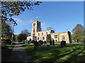
32m ESE 109° St Peter's Minster (Conisbrough)* Sculptured Stone (SK512988)
948m NNE 21° Cadeby Henge Henge (SK515997)
3.5km NNE 26° Scabba Wood Rock Shelter Cave or Rock Shelter (SE527020)
3.6km E 91° Edlington Woods* Cave or Rock Shelter (SK548988)
7.9km ENE 59° Doncaster Museum and Art Gallery* Museum (SE579030)
11.0km WSW 256° Roman Ridge (Rotherham)* Misc. Earthwork (SK40499598)
12.1km N 355° Little John's Well (Hampole)* Holy Well or Sacred Spring (SE4988810873)
12.2km WSW 253° Scholes Wood* Hillfort (SK395952)
13.0km N 4° Robin Hood's Well (Burghwallis)* Holy Well or Sacred Spring (SE51901175)
14.0km NNW 327° South Kirby Camp* Hillfort (SE435105)
14.1km NW 323° Ringstone Hill (Brierley) Stone Circle (SE42571005)
14.4km W 259° St. Helen's Well (Thorpe Hesley) Holy Well or Sacred Spring (SK370960)
15.4km S 175° Dead Man's Cave/Anston Stones Wood* Cave or Rock Shelter (SK5276283530)
15.4km WSW 240° Wincobank* Vitrified Fort (SK378910)
16.0km SSE 159° St Mary's Well (Wallingwells) Holy Well or Sacred Spring (SK572840)
16.5km WSW 254° Ecclesfield* Ancient Cross (SK353941)
16.7km SW 233° Darnall Common* Modern Stone Circle etc (SK378887)
17.9km W 263° Robin Hood Well (Yorkshire South)* Holy Well or Sacred Spring (SK334964)
18.1km NE 42° Bransdale Ridge BS1* Marker Stone (SE6318012415)
18.2km WNW 290° Worsborough Common Hillfort (SE340050)
18.3km SW 215° Birley Spa Holy Well or Sacred Spring (SK40908361)
19.5km S 176° Thorpe Common Shelter Cave or Rock Shelter (SK529794)
20.1km WNW 283° Stainborough Castle* Hillfort (SE315030)
20.3km W 263° Burnt Hill Plantation* Rock Art (SK310960)
20.7km WSW 237° Weston Park Museum* Museum (SK3389487292)
View more nearby sites and additional images


 We would like to know more about this location. Please feel free to add a brief description and any relevant information in your own language.
 Wir möchten mehr über diese Stätte erfahren. Bitte zögern Sie nicht, eine kurze Beschreibung und relevante Informationen in Deutsch hinzuzufügen.
 Nous aimerions en savoir encore un peu sur les lieux. S'il vous plaît n'hesitez pas à ajouter une courte description et tous les renseignements pertinents dans votre propre langue.
 Quisieramos informarnos un poco más de las lugares. No dude en añadir una breve descripción y otros datos relevantes en su propio idioma.