

<< Our Photo Pages >> Les Buttes de Monthault - Natural Stone / Erratic / Other Natural Feature in France in Bretagne:Ille-et-Vilaine (35)
Submitted by thereddragon on Saturday, 06 October 2012 Page Views: 2938
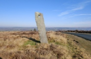
Natural PlacesSite Name: Les Buttes de Monthault Alternative Name: La pierre au sacrifice, La pierre au diable, La pierre au moineCountry: France
NOTE: This site is 4.363 km away from the location you searched for.
Département: Bretagne:Ille-et-Vilaine (35) Type: Natural Stone / Erratic / Other Natural Feature
Nearest Town: Louvigné-du-Désert Nearest Village: Monthault
Latitude: 48.518681N Longitude: 1.186202W
Condition:
| 5 | Perfect |
| 4 | Almost Perfect |
| 3 | Reasonable but with some damage |
| 2 | Ruined but still recognisable as an ancient site |
| 1 | Pretty much destroyed, possibly visible as crop marks |
| 0 | No data. |
| -1 | Completely destroyed |
| 5 | Superb |
| 4 | Good |
| 3 | Ordinary |
| 2 | Not Good |
| 1 | Awful |
| 0 | No data. |
| 5 | Can be driven to, probably with disabled access |
| 4 | Short walk on a footpath |
| 3 | Requiring a bit more of a walk |
| 2 | A long walk |
| 1 | In the middle of nowhere, a nightmare to find |
| 0 | No data. |
| 5 | co-ordinates taken by GPS or official recorded co-ordinates |
| 4 | co-ordinates scaled from a detailed map |
| 3 | co-ordinates scaled from a bad map |
| 2 | co-ordinates of the nearest village |
| 1 | co-ordinates of the nearest town |
| 0 | no data |
Internal Links:
External Links:
I have visited· I would like to visit
thereddragon has visited here
")
La pierre au sacrifice - Supposedly Celtic (Armorican) sacrifice stone.
La pierre au diable - Another boulder dropped whilst the devil was trying to stop St Michel.
La pierre au moine - Looks like a dolmen but is a natural formation
The destroyed Pierre des Fées menhir must have been close to this site.
Signposted from Monthault.
Access is easy, walk towards the church and take the left hand path just before it.
We only spent an hour walking around the outer paths and in the wood itself until we returned to the noticeboard and finally discovered the above stones.
There are so many stones, I'm surprised they haven't named a few more!
You may be viewing yesterday's version of this page. To see the most up to date information please register for a free account.
")
")
")
")
")
")
")
")
")
")
Do not use the above information on other web sites or publications without permission of the contributor.
Click here to see more info for this site
Nearby sites
Click here to view sites on an interactive map of the areaKey: Red: member's photo, Blue: 3rd party photo, Yellow: other image, Green: no photo - please go there and take one, Grey: site destroyed
Download sites to:
KML (Google Earth)
GPX (GPS waypoints)
CSV (Garmin/Navman)
CSV (Excel)
To unlock full downloads you need to sign up as a Contributory Member. Otherwise downloads are limited to 50 sites.
Turn off the page maps and other distractions
Nearby sites listing. In the following links * = Image available
703m ESE 105° Pierre des Fées (Monthault) Standing Stone (Menhir)
9.9km W 280° St-Benoit polissoir* Polissoir
12.6km S 170° Celliers de Landéan Cave or Rock Shelter
13.6km E 82° Les Cartesières* Passage Grave
13.7km S 172° Pierre du Trésor* Burial Chamber or Dolmen
13.8km S 180° Pierre Courcoulée (Landean)* Passage Grave
14.3km S 170° Cordon des Druides* Stone Row / Alignment
15.1km SSW 200° Allée Couverte le Rocher Jacquot* Passage Grave
15.1km SSW 200° Cupules du Rocher Jacquot Rock Art
16.2km WSW 253° Cromlech de Blanche Lande Stone Circle
18.8km N 4° Dolmen de la Guérinière Burial Chamber or Dolmen
19.0km N 356° Menhir de la Roche au Diable* Standing Stone (Menhir)
19.0km N 3° Pierres de la Guérinière* Standing Stone (Menhir)
19.1km SE 124° La Hutte-aux-Gabelous* Passage Grave
19.9km N 355° Dolmen du Petit-Celland Burial Chamber or Dolmen
20.1km N 350° Camp de Chatelier* Hillfort
24.0km SE 135° Broussardière Menhir* Standing Stone (Menhir)
24.1km ESE 103° Désertines Menhir* Standing Stone (Menhir)
24.3km NE 56° Rocher du Dolmen (Mortain)* Natural Stone / Erratic / Other Natural Feature
24.4km W 266° Menhir La Roche du Diable (Sougéal)* Standing Stone (Menhir)
25.2km W 275° Roche Buquet* Standing Stone (Menhir)
25.8km SSE 147° Allée Couverte du Bois de Broussault* Passage Grave
26.0km NE 50° Le Dolmen de Roche-Grise Burial Chamber or Dolmen
26.2km W 260° La Barre Canto Standing Stone (Menhir)
26.4km W 265° Menhir de la Pierre Fichée (La Pinelais)* Standing Stone (Menhir)
View more nearby sites and additional images


 We would like to know more about this location. Please feel free to add a brief description and any relevant information in your own language.
 Wir möchten mehr über diese Stätte erfahren. Bitte zögern Sie nicht, eine kurze Beschreibung und relevante Informationen in Deutsch hinzuzufügen.
 Nous aimerions en savoir encore un peu sur les lieux. S'il vous plaît n'hesitez pas à ajouter une courte description et tous les renseignements pertinents dans votre propre langue.
 Quisieramos informarnos un poco más de las lugares. No dude en añadir una breve descripción y otros datos relevantes en su propio idioma.