


<< Text Pages >> Dolmen du marais de Grée - Burial Chamber or Dolmen in France in Pays de la Loire:Loire-Atlantique
Submitted by AlexHunger on Saturday, 16 April 2005 Page Views: 2372
Neolithic and Bronze AgeSite Name: Dolmen du marais de GréeCountry: France
NOTE: This site is 9.563 km away from the location you searched for.
Département: Pays de la Loire:Loire-Atlantique Type: Burial Chamber or Dolmen
Nearest Town: Nantes Nearest Village: Ancenis
Latitude: 47.392930N Longitude: 1.16907W
Condition:
| 5 | Perfect |
| 4 | Almost Perfect |
| 3 | Reasonable but with some damage |
| 2 | Ruined but still recognisable as an ancient site |
| 1 | Pretty much destroyed, possibly visible as crop marks |
| 0 | No data. |
| -1 | Completely destroyed |
| 5 | Superb |
| 4 | Good |
| 3 | Ordinary |
| 2 | Not Good |
| 1 | Awful |
| 0 | No data. |
| 5 | Can be driven to, probably with disabled access |
| 4 | Short walk on a footpath |
| 3 | Requiring a bit more of a walk |
| 2 | A long walk |
| 1 | In the middle of nowhere, a nightmare to find |
| 0 | No data. |
| 5 | co-ordinates taken by GPS or official recorded co-ordinates |
| 4 | co-ordinates scaled from a detailed map |
| 3 | co-ordinates scaled from a bad map |
| 2 | co-ordinates of the nearest village |
| 1 | co-ordinates of the nearest town |
| 0 | no data |
Internal Links:
External Links:
Dolmen in Loire-Atlantique
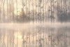
Debris of Large Dolmen in middle of Swamp
IMPORTANT NOTE: Site believed to be near this position
You may be viewing yesterday's version of this page. To see the most up to date information please register for a free account.
Do not use the above information on other web sites or publications without permission of the contributor.
Nearby Images from Flickr


The above images may not be of the site on this page, but were taken nearby. They are loaded from Flickr so please click on them for image credits.
Click here to see more info for this site
Nearby sites
Click here to view sites on an interactive map of the areaKey: Red: member's photo, Blue: 3rd party photo, Yellow: other image, Green: no photo - please go there and take one, Grey: site destroyed
Download sites to:
KML (Google Earth)
GPX (GPS waypoints)
CSV (Garmin/Navman)
CSV (Excel)
To unlock full downloads you need to sign up as a Contributory Member. Otherwise downloads are limited to 50 sites.
Turn off the page maps and other distractions
Nearby sites listing. In the following links * = Image available
2.6km SSE 155° Menhir de Juigné* Standing Stone (Menhir)
2.7km S 186° La Pierre Couvretière (Ancenis)* Burial Chamber or Dolmen
5.2km SW 227° Pierre Meslière* Ancient Village or Settlement
5.3km SW 225° Pierres Meslières Menhirs* Standing Stones
6.5km SSW 200° La Pierre du Diable (Drain) Standing Stone (Menhir)
9.6km S 181° Pierres du Diable Standing Stones
12.0km WSW 249° La Pierre Blanche (Oudon)* Standing Stone (Menhir)
12.7km SW 226° Pierre Levée de la Merciere Standing Stone (Menhir)
16.8km ESE 119° Dolmen du Moulin Moreau* Burial Chamber or Dolmen
18.4km E 87° La Pierre de Bretagne Standing Stone (Menhir)
19.4km NNE 18° Alignements de Bennefraye* Stone Row / Alignment
20.5km SW 233° La Pierre Percée (La Chapelle-Basse-Mer)* Modern Stone Circle etc
21.3km ENE 70° Champ-du-Ruisseau polissoir Polissoir
21.3km ENE 70° Dolmen du Champ-du-Ruisseau* Burial Chamber or Dolmen
21.6km E 85° Dolmen de la Boire de Champtocé Burial Chamber or Dolmen
21.8km SSE 149° Menhir de Breau* Standing Stone (Menhir)
22.4km SSE 148° La Pierre Aubrée Standing Stone (Menhir)
23.1km SSE 155° Camp de César (Le Fief-Sauvin) Ancient Village or Settlement
23.5km NNW 339° Menhir de Chapeneille Standing Stone (Menhir)
23.7km E 83° Dolmen de Romme Burial Chamber or Dolmen
25.2km SSE 154° Trois Menhirs du Carrefour Simon Standing Stones
25.8km NNW 339° Chapeneille Menhirs* Standing Stones
26.6km E 79° Pierre des Trois Paroisses Standing Stone (Menhir)
26.9km NW 317° Dolmen du Perron Burial Chamber or Dolmen
28.0km ENE 70° Pierre du Ruisseau de la Planche Standing Stone (Menhir)
View more nearby sites and additional images


 We would like to know more about this location. Please feel free to add a brief description and any relevant information in your own language.
 Wir möchten mehr über diese Stätte erfahren. Bitte zögern Sie nicht, eine kurze Beschreibung und relevante Informationen in Deutsch hinzuzufügen.
 Nous aimerions en savoir encore un peu sur les lieux. S'il vous plaît n'hesitez pas à ajouter une courte description et tous les renseignements pertinents dans votre propre langue.
 Quisieramos informarnos un poco más de las lugares. No dude en añadir una breve descripción y otros datos relevantes en su propio idioma.