<< Our Photo Pages >> Mesolithic structure near Vauxhall bridge - Timber Circle in England in Greater London
Submitted by Andy B on Thursday, 06 January 2011 Page Views: 22061
Neolithic and Bronze AgeSite Name: Mesolithic structure near Vauxhall bridgeCountry: England County: Greater London Type: Timber Circle
Nearest Town: London Nearest Village: Vauxhall
Map Ref: TQ30217814
Latitude: 51.487227N Longitude: 0.126016W
Condition:
| 5 | Perfect |
| 4 | Almost Perfect |
| 3 | Reasonable but with some damage |
| 2 | Ruined but still recognisable as an ancient site |
| 1 | Pretty much destroyed, possibly visible as crop marks |
| 0 | No data. |
| -1 | Completely destroyed |
| 5 | Superb |
| 4 | Good |
| 3 | Ordinary |
| 2 | Not Good |
| 1 | Awful |
| 0 | No data. |
| 5 | Can be driven to, probably with disabled access |
| 4 | Short walk on a footpath |
| 3 | Requiring a bit more of a walk |
| 2 | A long walk |
| 1 | In the middle of nowhere, a nightmare to find |
| 0 | No data. |
| 5 | co-ordinates taken by GPS or official recorded co-ordinates |
| 4 | co-ordinates scaled from a detailed map |
| 3 | co-ordinates scaled from a bad map |
| 2 | co-ordinates of the nearest village |
| 1 | co-ordinates of the nearest town |
| 0 | no data |
Internal Links:
External Links:
I have visited· I would like to visit
Andy B has visited here
")
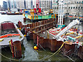
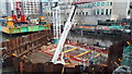
As they surveyed the foreshore in spring of 2010, archaeologists from TDP found six timber piles of up to 0.3 metres in diameter. Although no definite alignment or function can yet be determined, it is clear that the piles formed part of a prehistoric structure which stood beside the river over 6000 years ago, during the Mesolithic period, when river levels were lower and the landscape very different. Structures of Mesolithic date are very rare anywhere in Britain.
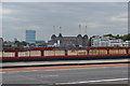
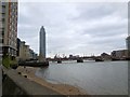
Kept secret until it could be fully recorded and investigated, the site is located at the confluence of the Rivers Effra and Thames. Near the timbers, late Mesolithic stone tools, including a fine tranchet adze (a woodworking tool), were also discovered, as well as slightly later Neolithic pottery of two distinct types. The area, may have been a significant, named place continuing through centuries or even millennia. It is only 600 m downstream from the Bronze Age timber-built bridge or jetty (c 1500 BC) which hit the headlines in the 1990s.
Archaeologists from TDP made the discovery as they investigated the area as part of a continuing project to record archaeological and historical remains on the foreshore. With support from English Heritage, the Museum of London and the geomatics team of Museum of London Archaeology a detailed survey was carried out, radiocarbon dates obtained for the six piles, and specialist analysis of the artefacts and environmental evidence performed.
The timbers are located very near the lowest tide level of the Thames. More evidence may be recovered in future since, like most of the astonishing remains that have been discovered on the foreshore – from huge collections of ships timbers to human burials to Saxon fish traps – the site is affected by the scour created by the twice-daily tides and the growing river traffic. The remains are also threatened by planned riverside developments, including the much needed Combined Sewer Overflow which will pass metres from the timbers. A major research project is underway.
The fieldwork was supported by grants from the Heritage Lottery Fund and from the Southwark and Lambeth Archaeological Excavation Committee.
‘London’s Top Secret’ by Gustav Milne, Nathalie Cohen and Jon Cotton, was published in London Archaeologist, Winter issue, vol 12 no 11, on 6 January 2011
Note: London’s oldest structure revealed, over 6000 years old.
You may be viewing yesterday's version of this page. To see the most up to date information please register for a free account.
")
")
Do not use the above information on other web sites or publications without permission of the contributor.
Nearby Images from Geograph Britain and Ireland:
©2010(licence)
©2020(licence)
©2019(licence)
©2014(licence)

©2013(licence)
The above images may not be of the site on this page, they are loaded from Geograph.
Please Submit an Image of this site or go out and take one for us!
Click here to see more info for this site
Nearby sites
Key: Red: member's photo, Blue: 3rd party photo, Yellow: other image, Green: no photo - please go there and take one, Grey: site destroyed
Download sites to:
KML (Google Earth)
GPX (GPS waypoints)
CSV (Garmin/Navman)
CSV (Excel)
To unlock full downloads you need to sign up as a Contributory Member. Otherwise downloads are limited to 50 sites.
Turn off the page maps and other distractions
Nearby sites listing. In the following links * = Image available
2.0km ENE 78° Cuming Museum Museum (TQ322786)
2.3km W 278° Tutankhamun: Treasures of the Golden Pharaoh exhibition, Saatchi Gallery* Museum (TQ279784)
2.4km N 9° Cleopatra's Needle (London)* Standing Stone (Menhir) (TQ3054380516)
3.3km NNE 24° Bridewell (Fleet Street) Holy Well or Sacred Spring (TQ315812)
3.5km N 358° British Museum* Museum (TQ300816)
3.6km NNW 346° The One and The Many* Modern Stone Circle etc (TQ2926981650)
3.6km NE 34° Broken Cross (Westminster) Ancient Cross (TQ322812)
3.7km NE 40° Mithras Temple (London)* Ancient Temple (TQ3252181031)
3.7km NE 43° London Stone* Standing Stone (Menhir) (TQ3267680903)
3.8km WNW 288° London Natural History Museum* Museum (TQ266792)
3.9km NNE 31° Museum of London* Museum (TQ321815)
4.0km NNE 25° Cow Cross (Finsbury) Ancient Cross (TQ31788181)
4.1km NE 52° All Hallows by the Tower* Museum (TQ3337380695)
4.1km N 353° Petrie Museum of Egyptian Archaeology* Museum (TQ2962882172)
4.2km NE 54° St Olave's Well* Holy Well or Sacred Spring (TQ335807)
4.2km NNE 19° Clerk's Well (Farringdon Lane) Holy Well or Sacred Spring (TQ3145282134)
4.2km NNE 16° Skinner's Well (Finsbury) Holy Well or Sacred Spring (TQ313822)
4.5km WNW 294° St Govor's Well* Holy Well or Sacred Spring (TQ2605079887)
7.7km ESE 114° Hilly Fields Stone Circle* Modern Stone Circle etc (TQ374752)
8.1km WNW 303° Kensal Green* Modern Stone Circle etc (TQ233824)
8.6km NNW 338° Chalybeate Well* Holy Well or Sacred Spring (TQ2671986055)
8.7km E 98° Greenwich Park Barrows* Barrow Cemetery (TQ3883677128)
8.8km NNW 343° Hampstead Heath Barrow* Round Barrow(s) (TQ2738286518)
9.0km WSW 236° Putney Heath Round Barrow(s) (TQ22797295)
9.3km S 181° Pollards Hill Hillfort (TQ303688)
View more nearby sites and additional images


 We would like to know more about this location. Please feel free to add a brief description and any relevant information in your own language.
 Wir möchten mehr über diese Stätte erfahren. Bitte zögern Sie nicht, eine kurze Beschreibung und relevante Informationen in Deutsch hinzuzufügen.
 Nous aimerions en savoir encore un peu sur les lieux. S'il vous plaît n'hesitez pas à ajouter une courte description et tous les renseignements pertinents dans votre propre langue.
 Quisieramos informarnos un poco más de las lugares. No dude en añadir una breve descripción y otros datos relevantes en su propio idioma.