<< Text Pages >> Þjóðveldisbærinn - Ancient Village or Settlement in Iceland
Submitted by CharcoalBurner89 on Tuesday, 15 March 2022 Page Views: 424
Early Medieval (Dark Age)Site Name: Þjóðveldisbærinn Alternative Name: Þjóðveldisbær, Þjóðveldisbær StöngCountry: Iceland
NOTE: This site is 42.54 km away from the location you searched for.
Type: Ancient Village or Settlement
Nearest Town: Selfoss
Latitude: 64.119990N Longitude: 19.82063W
Condition:
| 5 | Perfect |
| 4 | Almost Perfect |
| 3 | Reasonable but with some damage |
| 2 | Ruined but still recognisable as an ancient site |
| 1 | Pretty much destroyed, possibly visible as crop marks |
| 0 | No data. |
| -1 | Completely destroyed |
| 5 | Superb |
| 4 | Good |
| 3 | Ordinary |
| 2 | Not Good |
| 1 | Awful |
| 0 | No data. |
| 5 | Can be driven to, probably with disabled access |
| 4 | Short walk on a footpath |
| 3 | Requiring a bit more of a walk |
| 2 | A long walk |
| 1 | In the middle of nowhere, a nightmare to find |
| 0 | No data. |
| 5 | co-ordinates taken by GPS or official recorded co-ordinates |
| 4 | co-ordinates scaled from a detailed map |
| 3 | co-ordinates scaled from a bad map |
| 2 | co-ordinates of the nearest village |
| 1 | co-ordinates of the nearest town |
| 0 | no data |
Be the first person to rate this site - see the 'Contribute!' box in the right hand menu.
Internal Links:
External Links:
Ancient Village or Settlement in Iceland
Þjóðveldisbær is a replica of the Viking Age Icelandic farm Stöng, which was buried under ash when Mount Hekla erupted in 1104.
The historically accurate reconstruction faithfully consists of three buildings - including a longhouse - and was begun in 1974 (until 1977) to commemorate the 1100th anniversary of the settlement of Iceland. The property is located at Þjórsárdalsvegur 32 and is intended to bring visitors closer to life on a Viking Age farm as realistically as possible.
You may be viewing yesterday's version of this page. To see the most up to date information please register for a free account.
")
Do not use the above information on other web sites or publications without permission of the contributor.
Nearby Images from Flickr
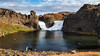

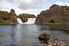
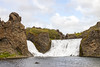
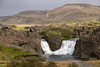

The above images may not be of the site on this page, but were taken nearby. They are loaded from Flickr so please click on them for image credits.
Click here to see more info for this site
Nearby sites
Click here to view sites on an interactive map of the areaKey: Red: member's photo, Blue: 3rd party photo, Yellow: other image, Green: no photo - please go there and take one, Grey: site destroyed
Download sites to:
KML (Google Earth)
GPX (GPS waypoints)
CSV (Garmin/Navman)
CSV (Excel)
To unlock full downloads you need to sign up as a Contributory Member. Otherwise downloads are limited to 50 sites.
Turn off the page maps and other distractions
Nearby sites listing. In the following links * = Image available
64.9km WNW 285° Althing* Natural Stone / Erratic / Other Natural Feature
67.5km S 170° Rútshellir Cave or Rock Shelter
93.6km ESE 112° Hildishaugur Cairn
94.4km SE 145° Hjörleifshaugur Cairn
103.0km W 273° Reykjavik Settlement Museum* Museum
111.3km WNW 295° The Settlement Center Museum
111.4km WNW 296° Skallagrimshaugur* Round Barrow(s)
132.7km W 264° Vikingaheimar* Museum
155.1km NNW 347° Borgarvirki* Promontory Fort / Cliff Castle
172.5km NW 308° Helgafell Natural Stone / Erratic / Other Natural Feature
198.7km NNE 22° Eyjafjörður Fjord* Artificial Mound
223.6km NW 316° Flókatóftir Ancient Village or Settlement
295.1km ENE 67° Völvuleiði Cairn
315.7km NNE 33° Arctic Henge Modern Stone Circle etc
321.1km NNE 32° Þorgeirsdys Cairn
677.0km ESE 103° Viking longhouse Kvívík, Faeröer Ancient Village or Settlement
689.9km ESE 102° Viking longhouse Leirvík, Faeröer Ancient Village or Settlement
755.1km NNW 341° Danmark Ø Hut Foundations* Ancient Village or Settlement
921.8km ESE 121° North Ronan Crosses Ancient Cross (HW80913231)
922.7km SE 134° Boreray* Stone Circle (NA15060499)
923.5km SE 134° Tobar nam Buadh (St Kilda) Holy Well or Sacred Spring (NA0864400247)
923.7km SE 134° The Amazon's House (Hirta) Ancient Village or Settlement (NA08780010)
924.3km SE 134° Gleann Mor* Standing Stones (NF08869943)
924.9km SE 134° House Of The Fairies* Souterrain (Fogou, Earth House) (NF1001799410)
947.2km SE 128° Loch Cleidir Crannog (NB03653437)
View more nearby sites and additional images


 We would like to know more about this location. Please feel free to add a brief description and any relevant information in your own language.
 Wir möchten mehr über diese Stätte erfahren. Bitte zögern Sie nicht, eine kurze Beschreibung und relevante Informationen in Deutsch hinzuzufügen.
 Nous aimerions en savoir encore un peu sur les lieux. S'il vous plaît n'hesitez pas à ajouter une courte description et tous les renseignements pertinents dans votre propre langue.
 Quisieramos informarnos un poco más de las lugares. No dude en añadir una breve descripción y otros datos relevantes en su propio idioma.