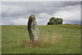
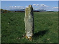
<< Other Photo Pages >> Rosskeen - Class I Pictish Symbol Stone in Scotland in Highlands
Submitted by alligator on Wednesday, 25 February 2004 Page Views: 8130
Early Medieval (Dark Age)Site Name: Rosskeen Alternative Name: Roskeen, Clach a'mheirlich -- The Thief's StoneCountry: Scotland
NOTE: This site is 0.934 km away from the location you searched for.
County: Highlands Type: Class I Pictish Symbol Stone
Map Ref: NH6809969024 Landranger Map Number: 21
Latitude: 57.691639N Longitude: 4.214327W
Condition:
| 5 | Perfect |
| 4 | Almost Perfect |
| 3 | Reasonable but with some damage |
| 2 | Ruined but still recognisable as an ancient site |
| 1 | Pretty much destroyed, possibly visible as crop marks |
| 0 | No data. |
| -1 | Completely destroyed |
| 5 | Superb |
| 4 | Good |
| 3 | Ordinary |
| 2 | Not Good |
| 1 | Awful |
| 0 | No data. |
| 5 | Can be driven to, probably with disabled access |
| 4 | Short walk on a footpath |
| 3 | Requiring a bit more of a walk |
| 2 | A long walk |
| 1 | In the middle of nowhere, a nightmare to find |
| 0 | No data. |
| 5 | co-ordinates taken by GPS or official recorded co-ordinates |
| 4 | co-ordinates scaled from a detailed map |
| 3 | co-ordinates scaled from a bad map |
| 2 | co-ordinates of the nearest village |
| 1 | co-ordinates of the nearest town |
| 0 | no data |
Be the first person to rate this site - see the 'Contribute!' box in the right hand menu.
Internal Links:
External Links:
Class I Pictish Symbol Stone in Scottish Highlands
You may be viewing yesterday's version of this page. To see the most up to date information please register for a free account.
Do not use the above information on other web sites or publications without permission of the contributor.
coldrum has found this location on Google Street View:
Nearby Images from Geograph Britain and Ireland:
©2010(licence)
©2007(licence)

©2023(licence)
©2008(licence)
©2022(licence)
The above images may not be of the site on this page, they are loaded from Geograph.
Please Submit an Image of this site or go out and take one for us!
Click here to see more info for this site
Nearby sites
Key: Red: member's photo, Blue: 3rd party photo, Yellow: other image, Green: no photo - please go there and take one, Grey: site destroyed
Download sites to:
KML (Google Earth)
GPX (GPS waypoints)
CSV (Garmin/Navman)
CSV (Excel)
To unlock full downloads you need to sign up as a Contributory Member. Otherwise downloads are limited to 50 sites.
Turn off the page maps and other distractions
Nearby sites listing. In the following links * = Image available
1.6km WNW 287° Carn Liath, Alness* Cairn (NH66626952)
2.9km NW 318° Nonakiln Class I Pictish Symbol Stone (NH66217124)
3.0km NW 309° Mill craig Chambered Tomb (NH658710)
4.0km NW 320° Cnoc Navie Chambered Cairn (NH656722)
4.6km N 1° Newmore Wood Rock Art (NH68327366)
5.8km NNW 330° Stittenham Cairn 2 Cairn (NH65367413)
6.1km NNW 328° The Ardross Wolf Class I Pictish Stone* Class I Pictish Symbol Stone (NH650743)
6.1km NW 325° Dalnavie Class I Pictish Symbol Stone (NH64737414)
6.2km NNW 327° Stittenham Cairn 1 Chambered Tomb (NH649743)
6.3km NNE 13° King's Head Cairn Chambered Cairn (NH69777513)
6.5km SSW 196° Mid Brae Chambered Cairn (NH661628)
6.6km NNE 14° Kinrive West Chambered Cairn (NH69937538)
7.1km NW 318° Carn Nam Fiann Chambered Cairn (NH63517441)
7.4km SSW 207° St Martin's Well (Fortrose)* Holy Well or Sacred Spring (NH645625)
7.9km NNE 23° Scotsburn House Dun* Stone Fort or Dun (NH71487616)
7.9km NNE 24° Scotsburn House Chambered Cairn Chambered Cairn (NH71537618)
8.0km SSW 196° Wester Brae* Chambered Cairn (NH65646139)
8.4km NW 323° Baldoon Chambered Cairn (NH63317591)
8.4km SE 139° Glenurquhart Grey Cairn* Cairn (NH73386247)
8.6km SSW 199° Woodhead Round Chambered Cairn* Chambered Cairn (NH650610)
8.6km NNE 26° Scotsburn Wood West Chambered Tomb (NH721767)
8.7km NW 309° Carn Na Feinne Chambered Cairn (NH615747)
8.8km SSW 197° Woodhead Long* Chambered Cairn (NH653607)
9.0km NNE 28° Scotsburn Wood East Chambered Tomb (NH726768)
9.5km WSW 253° Carn Liath (Upper Park) Chambered Cairn (NH589665)
View more nearby sites and additional images


 We would like to know more about this location. Please feel free to add a brief description and any relevant information in your own language.
 Wir möchten mehr über diese Stätte erfahren. Bitte zögern Sie nicht, eine kurze Beschreibung und relevante Informationen in Deutsch hinzuzufügen.
 Nous aimerions en savoir encore un peu sur les lieux. S'il vous plaît n'hesitez pas à ajouter une courte description et tous les renseignements pertinents dans votre propre langue.
 Quisieramos informarnos un poco más de las lugares. No dude en añadir una breve descripción y otros datos relevantes en su propio idioma.