


<< Our Photo Pages >> Harelaw - Misc. Earthwork in Scotland in Scottish Borders
Submitted by mafenty on Wednesday, 14 February 2007 Page Views: 4989
Multi-periodSite Name: Harelaw Alternative Name: Harelaw FortCountry: Scotland
NOTE: This site is 3.104 km away from the location you searched for.
County: Scottish Borders Type: Misc. Earthwork
Nearest Town: Greenlaw
Map Ref: NT66444834
Latitude: 55.727298N Longitude: 2.535895W
Condition:
| 5 | Perfect |
| 4 | Almost Perfect |
| 3 | Reasonable but with some damage |
| 2 | Ruined but still recognisable as an ancient site |
| 1 | Pretty much destroyed, possibly visible as crop marks |
| 0 | No data. |
| -1 | Completely destroyed |
| 5 | Superb |
| 4 | Good |
| 3 | Ordinary |
| 2 | Not Good |
| 1 | Awful |
| 0 | No data. |
| 5 | Can be driven to, probably with disabled access |
| 4 | Short walk on a footpath |
| 3 | Requiring a bit more of a walk |
| 2 | A long walk |
| 1 | In the middle of nowhere, a nightmare to find |
| 0 | No data. |
| 5 | co-ordinates taken by GPS or official recorded co-ordinates |
| 4 | co-ordinates scaled from a detailed map |
| 3 | co-ordinates scaled from a bad map |
| 2 | co-ordinates of the nearest village |
| 1 | co-ordinates of the nearest town |
| 0 | no data |
Internal Links:
External Links:
")
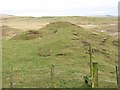
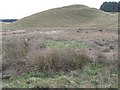
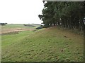
It has a central summit and what appears to be a ramp access route along to the nearby ridge. The Royal Commission for Ancient Monuments (RCAHMS) states "its date and purpose are not clear".
For more information see Canmore ID 57289 which adds: "This fort is situated on the right bank of the Blackadder, at an elevation of some 640ft OD. It comprises an oval enclosure measuring some 141ft by 71ft within a single rampart, accompanied by an internal ditch. The entrance is in the NE. There are two or three slight indications of hut circles in the interior."
Their record contains a plan and cross-sections of the fort which are available to download for private use from the 'Collections' tab.
You may be viewing yesterday's version of this page. To see the most up to date information please register for a free account.
")
Do not use the above information on other web sites or publications without permission of the contributor.
Nearby Images from Geograph Britain and Ireland:
©2007(licence)
©2007(licence)
©2007(licence)
©2007(licence)
©2022(licence)
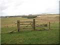
The above images may not be of the site on this page, they are loaded from Geograph.
Please Submit an Image of this site or go out and take one for us!
Click here to see more info for this site
Nearby sites
Key: Red: member's photo, Blue: 3rd party photo, Yellow: other image, Green: no photo - please go there and take one, Grey: site destroyed
Download sites to:
KML (Google Earth)
GPX (GPS waypoints)
CSV (Garmin/Navman)
CSV (Excel)
To unlock full downloads you need to sign up as a Contributory Member. Otherwise downloads are limited to 50 sites.
Turn off the page maps and other distractions
Nearby sites listing. In the following links * = Image available
5.7km E 88° Herriot's Dyke* Misc. Earthwork (NT722485)
5.8km E 100° Piersknowe Plantation* Cairn (NT72174726)
6.8km WNW 282° Bruntaburn Mill* Standing Stone (Menhir) (NT59814979)
6.8km NW 326° Kingside Hill (Cranshaws) Stone Circle (NT62635403)
7.5km NNW 327° Twin Law Cairns* Cairn (NT624547)
8.0km W 269° Cambridge Standing Stone* Standing Stone (Menhir) (NT58434826)
8.2km W 277° Blythe Fort Hillfort (NT58244941)
8.4km WSW 256° Dods Corse Stone (Boon)* Ancient Cross (NT58214633)
9.4km W 270° Thirlestane Hill Hillfort (NT57054845)
9.4km ENE 56° Raecleughhead* Hillfort (NT74355351)
10.9km SW 218° Purveshaugh* Standing Stone (Menhir) (NT59663973)
11.3km WNW 290° Borrowstone Rig Round Cairn (NT55775223)
11.4km WNW 290° Borrowstone Rig* Stone Circle (NT55765231)
11.4km WNW 290° Borrowston Rigg* Stone Circle (NT5576052315)
11.4km ESE 122° Crosshall Cross* Ancient Cross (NT76064223)
11.5km NNW 338° Mutiny Stones* Cairn (NT62255902)
12.0km WNW 283° Dabshead Hill* Standing Stone (Menhir) (NT54715124)
12.7km SSE 149° Piper's Grave Cists Cist (NT72923739)
12.9km SSW 199° Cow Stone (Scottish Borders)* Standing Stone (Menhir) (NT62163620)
13.1km SSW 200° Brothers' Stones* Standing Stones (NT61903600)
13.3km ENE 65° Duns Mercat Cross* Ancient Cross (NT7855253883)
13.6km ENE 62° Duns Law Hillfort* Hillfort (NT78505468)
14.3km NE 54° Cumledge Cist* Cist (NT782566)
14.8km N 360° Kilmade Hillfort* Hillfort (NT66456315)
15.0km N 350° Penshiel Grange Stone Circle* Stone Circle (NT64016317)
View more nearby sites and additional images


 We would like to know more about this location. Please feel free to add a brief description and any relevant information in your own language.
 Wir möchten mehr über diese Stätte erfahren. Bitte zögern Sie nicht, eine kurze Beschreibung und relevante Informationen in Deutsch hinzuzufügen.
 Nous aimerions en savoir encore un peu sur les lieux. S'il vous plaît n'hesitez pas à ajouter une courte description et tous les renseignements pertinents dans votre propre langue.
 Quisieramos informarnos un poco más de las lugares. No dude en añadir una breve descripción y otros datos relevantes en su propio idioma.